
Amherst, Ohio facts for kids
Quick facts for kids
Amherst, Ohio
|
|
|---|---|

Amherst Town Hall
|
|
| Nickname(s):
Hurst
|
|
| Motto(s):
"Sandstone Center of the World"
|
|

Location in Greater Cleveland
|
|

Amherst, Ohio
Location in Ohio

Amherst, Ohio
Location in the United States
|
|
| Country | United States |
| State | Ohio |
| County | Lorain |
| Area | |
| • Total | 7.14 sq mi (18.50 km2) |
| • Land | 7.08 sq mi (18.35 km2) |
| • Water | 0.06 sq mi (0.16 km2) |
| Elevation | 646 ft (197 m) |
| Population
(2020)
|
|
| • Total | 12,681 |
| • Estimate
(2023)
|
12,928 |
| • Density | 1,790.09/sq mi (691.15/km2) |
| Time zone | UTC-5 (Eastern (EST)) |
| • Summer (DST) | UTC-4 (EDT) |
| ZIP code |
44001
|
| Area code(s) | 440 |
| FIPS code | 39-01798 |
| GNIS feature ID | 1086498 |
| Website | http://www.amherstohio.org/ |
Amherst is a city in Lorain County, Ohio, United States. It is located about 28 miles (45 km) west of Cleveland. The city is part of the larger Cleveland metropolitan area. In 2020, the population of Amherst was 12,681 people.
Contents
History of Amherst

The area that became Amherst was first settled by pioneers. Jacob Shupe arrived in 1811. The main downtown area was settled by Josiah Harris in 1818.
The tiny village was first known as "Amherst Corners" in the early 1830s. In 1836, it was officially recorded as the "town plat of Amherst." Later, around 1839, it was called "Amherstville." It then became "North Amherst" before finally being named "Amherst" in 1909.
In the late 1800s, Amherst became known as the Sandstone Center of the World. Many old buildings in the city are made from local sandstone. The quarries here were also important for making grindstones. At its busiest, there were nine sandstone quarries operating in the area.
Geography and Climate
Amherst is part of the Greater Cleveland area. It is located about 2.5 miles (4 km) south of Lake Erie.
According to the 2010 census, the city covers about 7.12 square miles (18.44 km²). Most of this area, about 7.06 square miles (18.29 km²), is land. Only a small part, about 0.06 square miles (0.16 km²), is water.
Amherst's Climate
Amherst has a humid continental climate. This means it has very warm to hot and humid summers. The winters are cold with a moderate amount of snow.
The city is in Hardiness Zone 6a/6b. This zone helps gardeners know which plants can survive the winter. Some tropical plants, like Needle Palms, can even grow in Amherst with a little protection.
| Climate data for Amherst, Ohio | |||||||||||||
|---|---|---|---|---|---|---|---|---|---|---|---|---|---|
| Month | Jan | Feb | Mar | Apr | May | Jun | Jul | Aug | Sep | Oct | Nov | Dec | Year |
| Mean daily maximum °F (°C) | 34 (1) |
36 (2) |
47 (8) |
58 (14) |
69 (21) |
80 (27) |
84 (29) |
81 (27) |
75 (24) |
65 (18) |
52 (11) |
39 (4) |
60 (16) |
| Mean daily minimum °F (°C) | 19 (−7) |
21 (−6) |
28 (−2) |
39 (4) |
48 (9) |
58 (14) |
62 (17) |
61 (16) |
55 (13) |
45 (7) |
37 (3) |
25 (−4) |
42 (5) |
| Average rainfall inches (mm) | 2.3 (58) |
2.1 (53) |
2.7 (69) |
3.3 (84) |
3.5 (89) |
3.9 (99) |
3.7 (94) |
3.6 (91) |
3.3 (84) |
2.5 (64) |
3.1 (79) |
2.7 (69) |
36.7 (930) |
| Average snowfall inches (cm) | 13.2 (34) |
11.8 (30) |
7.0 (18) |
1.1 (2.8) |
0.1 (0.25) |
0 (0) |
0 (0) |
0 (0) |
0 (0) |
0.1 (0.25) |
3.0 (7.6) |
11.0 (28) |
45.0 (114) |
People in Amherst
| Historical population | |||
|---|---|---|---|
| Census | Pop. | %± | |
| 1880 | 1,542 | — | |
| 1890 | 1,648 | 6.9% | |
| 1900 | 1,758 | 6.7% | |
| 1910 | 2,106 | 19.8% | |
| 1920 | 2,485 | 18.0% | |
| 1930 | 2,844 | 14.4% | |
| 1940 | 2,896 | 1.8% | |
| 1950 | 3,542 | 22.3% | |
| 1960 | 6,750 | 90.6% | |
| 1970 | 9,902 | 46.7% | |
| 1980 | 10,620 | 7.3% | |
| 1990 | 10,332 | −2.7% | |
| 2000 | 11,797 | 14.2% | |
| 2010 | 12,021 | 1.9% | |
| 2020 | 12,681 | 5.5% | |
| 2023 (est.) | 12,928 | 7.5% | |
| U.S. Decennial Census | |||
2020 Census Information
In 2020, Amherst had 12,681 people living in 4,886 households. This means there were about 1,790 people per square mile. Most of the people (92.1%) were White. About 1.4% were African American, and 2.0% were Asian. Around 6.3% of the population was of Hispanic or Latino background.
About 22.3% of the people were under 18 years old. About 21.4% were 65 years or older. The population was almost evenly split between females (49.9%) and males (50.1%).
The average income for a household was $78,716. The income per person was $42,241. About 4.9% of the people lived below the poverty line.
2010 Census Information
In 2010, there were 12,021 people living in Amherst. There were 4,772 households and 3,463 families. The city had about 1,703 people per square mile.
About 95.7% of the people were White. Around 0.7% were African American, and 0.7% were Asian. About 5.3% of the population was Hispanic or Latino.
About 30.8% of households had children under 18. Most households (57.7%) were married couples. The average age in the city was 45 years. About 22.1% of residents were under 18. About 17.8% were 65 years or older.
Economy and Jobs

Amherst is home to a Nordson factory. This factory makes many different products. KTM-Sportmotorcycle America also has its main office here.
In the city's downtown area, you can find Ben Franklin's dime store. It sells things like fish, aquarium supplies, model cars, and puzzles. Amherst also has Ziggy's, a popular bar and grill that President Obama visited in 2012.
Getting Around Amherst
Most people in Amherst use cars to travel. However, the downtown area is easy to walk around.
State Route 2 runs through the northern part of Amherst. This road connects the city to downtown Cleveland (about 38 minutes away) and Sandusky, Ohio. There are two exits for Amherst from this route. The Ohio Turnpike also runs along the city's southern edge. There is an exit just south of the city.
The Lorain County Transit system also serves parts of Amherst. The closest international airport is Cleveland Hopkins (CLE). It is about 35 minutes east of the city.
Famous People from Amherst

Many interesting people have come from Amherst:
- Guy Carlton – A weightlifter who won an Olympic medal.
- Mike Finley – An author who has written over 110 books.
- Jim Hayford – A basketball head coach for Seattle University.
- Joel Hills Johnson – An inventor, poet, and judge.
- Mika Johnson – A filmmaker and musician.
- Jerry Lawler – A professional wrestler and commentator.
- John Penton – A motorcycle racer and member of the AMA Motorcycle Hall of Fame.
- Ryan Rua – A professional baseball player.
- Henry Dwight Stratton – The person who founded Bryant & Stratton College.
Images for kids
-
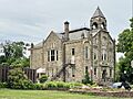
Amherst Town Hall
-
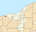
Location of Amherst in Greater Cleveland
See also
 In Spanish: Amherst (Ohio) para niños
