Erie County, Ohio facts for kids
Quick facts for kids
Erie County
|
|||
|---|---|---|---|
|
|||
|
|||
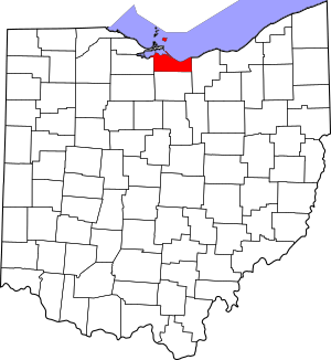
Location within the U.S. state of Ohio
|
|||
 Ohio's location within the U.S. |
|||
| Country | |||
| State | |||
| Founded | March 16, 1838 | ||
| Named for | Erie tribe | ||
| Seat | Sandusky | ||
| Largest city | Sandusky | ||
| Area | |||
| • Total | 626 sq mi (1,620 km2) | ||
| • Land | 252 sq mi (650 km2) | ||
| • Water | 374 sq mi (970 km2) 60%% | ||
| Population
(2020)
|
|||
| • Total | 75,622 |
||
| • Density | 120/sq mi (50/km2) | ||
| Time zone | UTC−5 (Eastern) | ||
| • Summer (DST) | UTC−4 (EDT) | ||
| Congressional district | 9th | ||
Erie County is a special area called a county in the northern part of Ohio, a state in the United States. In 2020, about 75,622 people lived there. The main city and government center is Sandusky, which is also the largest city.
The county got its name from the Erie tribe. Their name meant "wildcat." Erie County was created in 1838. It was formed from parts of Huron County and Sandusky County. Erie County is part of a larger area called the Sandusky, OH Metropolitan Statistical Area. This area is also part of the Cleveland-Akron-Canton, OH Combined Statistical Area.
Contents
History of Erie County
Erie County was officially created in 1838. It was formed from a section of Huron County. There were a few small changes to Erie County's borders soon after it was first made.
Geography and Nature
Erie County covers a total area of about 626 square miles (1,621 square kilometers). Most of this area, about 60%, is water, mainly from Lake Erie. The land area is about 252 square miles (653 square kilometers). This makes it the second-smallest county in Ohio by land size.
The county borders Lake Erie to the north. Across the lake are two counties in Ontario, Canada. The Huron River and Vermilion River flow through Erie County. Near the Huron River, you can find old earth mounds and enclosures. These were built by early Native American groups. The city of Sandusky has many valuable limestone quarries. The land in Erie County is mostly flat, and the soil is very rich and good for farming.
Neighboring Areas
Erie County shares borders with several other counties and municipalities:
- Essex County, Ontario, Canada (to the north, across Lake Erie)
- Chatham-Kent municipality, Ontario, Canada (to the north, across Lake Erie)
- Lorain County (to the east)
- Huron County (to the south)
- Sandusky County (to the west)
- Ottawa County (to the northwest)
Main Roads and Highways
Many important roads pass through Erie County. These highways help people travel around the county and to other parts of Ohio.

 I-80 / I-90 (Ohio Turnpike)
 US 6
US 6 US 250
 SR 2
SR 2 SR 4
SR 4 SR 13
SR 13 SR 60
SR 60 SR 61
SR 61 SR 99
SR 99 SR 101
 SR 113
 SR 269
Population and People
| Historical population | |||
|---|---|---|---|
| Census | Pop. | %± | |
| 1840 | 12,599 | — | |
| 1850 | 18,568 | 47.4% | |
| 1860 | 24,474 | 31.8% | |
| 1870 | 28,188 | 15.2% | |
| 1880 | 32,640 | 15.8% | |
| 1890 | 35,462 | 8.6% | |
| 1900 | 37,650 | 6.2% | |
| 1910 | 38,327 | 1.8% | |
| 1920 | 39,789 | 3.8% | |
| 1930 | 42,133 | 5.9% | |
| 1940 | 43,201 | 2.5% | |
| 1950 | 52,565 | 21.7% | |
| 1960 | 68,000 | 29.4% | |
| 1970 | 75,909 | 11.6% | |
| 1980 | 79,655 | 4.9% | |
| 1990 | 76,779 | −3.6% | |
| 2000 | 79,551 | 3.6% | |
| 2010 | 77,079 | −3.1% | |
| 2020 | 75,622 | −1.9% | |
| U.S. Decennial Census 1790-1960 1900-1990 1990-2000 2020 |
|||
In 2010, there were 77,079 people living in Erie County. There were 31,860 households, which are groups of people living together. The average age of people in the county was 43.4 years old.
The median income for a household was about $46,593 per year. For families, the median income was about $61,247 per year. This means half of the households earned more than this amount, and half earned less. About 12.5% of all people in the county lived below the poverty line. This included 17.1% of those under 18 years old.
Education in Erie County
Many different school districts serve the students of Erie County. Some districts cover parts of several towns or townships.
- Bellevue City School District: Serves parts of Bellevue and Groton Township.
- Edison Local School District: Includes parts of Berlin Heights and Milan, plus several townships.
- Firelands Local School District: Serves parts of Florence Township.
- Huron City School District: Includes parts of Huron and nearby townships.
- Kelleys Island Local School District: Covers all of Kelleys Island.
- Margaretta Local School District: Serves parts of Bay View and Castalia, and two townships.
- Monroeville Local School District: Includes parts of Oxford Township.
- Perkins Local School District: Covers parts of several townships like Groton and Perkins.
- Sandusky Central Catholic Schools: These schools serve the three Catholic parishes in Sandusky.
- St. Peter's School: A private Catholic elementary school located in Huron.
- Sandusky City School District: Serves all of Sandusky.
- Vermilion Local School District: Includes parts of Vermilion and two townships.
- Western Reserve Local School District: Covers parts of Florence Township.
Communities in Erie County
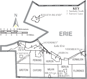
Erie County has several types of communities, including cities, villages, and townships.
Cities in Erie County
- Bellevue (part of this city is in Erie County)
- Huron
- Sandusky (This is the county seat, where the main government offices are)
- Vermilion (part)
Villages in Erie County
Townships in Erie County
Townships are smaller areas of land, often with their own local government.
- Berlin
- Florence
- Groton
- Huron
- Margaretta
- Milan
- Oxford
- Perkins
- Vermilion
Other Communities
Erie County also has smaller communities that are not officially cities, villages, or townships.
- Beulah Beach (a census-designated place)
- Crystal Rock (a census-designated place)
- Mitiwanga (a census-designated place)
- Whites Landing (a census-designated place)
- Avery (an unincorporated community)
- Axtel (an unincorporated community)
- Birmingham (an unincorporated community)
- Bloomingville (an unincorporated community)
- Bogart (an unincorporated community)
- Ceylon (an unincorporated community)
- Fairview Lanes (an unincorporated community)
- Florence (an unincorporated community)
- Ruggles Beach (an unincorporated community)
- Sandusky South (an unincorporated community)
Fun Places to Visit
Erie County has several interesting places that people like to visit.
- Blue Hole: A natural spring with very clear blue water.
- Cedar Point: A famous amusement park known for its many roller coasters.
- Plum Brook Station: A NASA research facility.
- Thomas Alva Edison Birthplace: The house where the famous inventor Thomas Edison was born.
Images for kids
See also
 In Spanish: Condado de Erie (Ohio) para niños
 | Laphonza Butler |
 | Daisy Bates |
 | Elizabeth Piper Ensley |


