
Huron River (Ohio) facts for kids
Quick facts for kids Huron River |
|
|---|---|

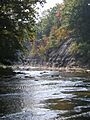
An early autumn scene of the west branch of the Huron River, near the towns of Milan, Monroeville, and Norwalk in north central Ohio.
|
|
| Country | United States |
| Physical characteristics | |
| Main source | East of Shiloh, Ohio 1,090 ft (330 m) |
| River mouth | Lake Erie at Huron, Ohio 571 ft (174 m) |
| Length | 15 miles (24 km) |
| Basin features | |
| Basin size | 406 sq mi (1,050 km2) |


The Huron River is a waterway about 14.9-mile-long (24.0 km) in north central Ohio, United States. It's an important river that flows through parts of Erie County, Huron County, and smaller parts of Seneca County, Crawford County, and Richland County.
The river ends by flowing into Lake Erie at the city of Huron. The main part of the Huron River is formed when its two main parts, the East Branch and the West Branch, join together near Milan.
The East Branch is about 31.8 miles (51.2 km) long. It starts west of Fitchville. It flows west to North Fairfield, then turns north. It passes through Peru and Norwalk before meeting the West Branch near Milan.
The West Branch is much longer, at about 54.5 miles (87.7 km). It begins about 4 miles (6.4 km) south of Greenwich and east of Shiloh. This area is close to where other rivers like the Vermilion River and Shipp Creek also begin. The West Branch flows north and west through several townships and towns like Plymouth, New Haven, and Monroeville. It then crosses into Erie County and turns east before joining the East Branch in the Milan State Wildlife Area.
Contents
What Smaller Streams Flow into the Huron River?
Many smaller streams and creeks flow into the Huron River, adding to its water. These are called tributaries. Some of the main ones include:
- Christiana Creek
- Clayton Ditch
- Cole Creek
- Frink Run
- Haas Ditch
- Jacobs Creek
- Marsh Run
- Megginson Creek
- Milan Village Creek
- Mud Brook
- Mud Run
- Norwalk Creek
- Old Woman Creek
- Rattlesnake Creek
- Sandhill Creek
- Schoeffel Ditch
- Seymour Creek
- Shriner Run
- Slate Run
- Walnut Creek
Did you know? Willard Marsh, a wetland area, feeds water into both the West Branch of the Huron River and Honey Creek, which is part of the Sandusky River.
What Are the Other Names for the Huron River?
Over time, the Huron River has been known by several different names. This often happened because different groups of people, like Native Americans and early European explorers, had their own names for it.
- Hurons River
- Notowacy Thepy or Naudowessie Sipi: These names come from the Chippewa and Lenape Native American languages. They mean "the River of the Huron tribe."
- Petquotting: This name comes from a Moravian village that was located near the river in the late 1700s.
- Riviere Huron or Riviere aux (Rx) Hurons: These are French names for the river.
- Bald Eagle Creek: This name was used in the 1700s because a very large bald eagle nest was found at the river's mouth.
- Huron Creek
- Guahadahuri and Canesadooharie: These are other Native American names that appeared on early maps. Their exact meanings are now lost.
The word "Huron" refers to a Native American tribe also known as the Wyandots. This tribe had many villages around Sandusky Bay in the late 1700s. European explorers started using the name "Huron River" by 1778.
In the late 1700s, the northern part of the river was a well-known trading spot for French-Canadian traders.
How Do Roads Cross the Huron River?
Many roads and bridges cross over the Huron River and its branches. This section lists some of the main crossings.
Roads Crossing the West Branch
The West Branch starts in Richland County and flows north to meet the East Branch.
Richland County Crossings
- Noble Road
- Pennel Road
- Baseline Road
Huron County Crossings
- Ashland Railway (a train track)
- Edwards Road
- Plymouth East Road
- Old State Road
- New State Road
- Wheeling and Lake Erie Railway (a train track)
- Plymouth East Road
- Townline Road 111
- Baseline Road
- Broadway Street (in Plymouth)
- North Street (in Plymouth)
- Plymouth East Road (in Plymouth)
- Skinner Road
 US 224
- Klein Road
- Greenbush Road
- Boughtonville Road
- CSX Transportation (a train track)
- Townline Road 12
- Olive Road
- Maple Ridge Road
 SR 61
SR 61 SR 162
- Hanville Corners Road
- Peru Center Road
- Bauman Road
- Troy Mills Road
- Fern Road
- Snyder Road
- Peru West Section Line Road
- Hettle Road
- Terry Road
- Standardsburg Road
- North Coast Inland Trail (a walking/biking path)
- Wheeling and Lake Erie Railway (a train track)
 US 20 (Main Street) (in Monroeville)
- River Road
- Lamereaux Road
Erie County Crossings
- Huber Road
- Lovers Lane Road
Roads Crossing the East Branch
The East Branch starts near Fitchville and flows west, then north, to meet the West Branch.
Huron County Crossings
- Crescent Road
- SR 162
- Greenwich Milan Townline Road
- Edwards Road
- Delta Road
- Fairfield Angling Road
- Old State Road
- New State Road (Main Street in North Fairfield)
- SR 162
- Hanville Corners Road
- Townline Road 131
- Ridge Road
- Townline Road 113
- SR 61
- Geiger Road
- Remelle Road
- Johnson Road
- Brown Road


 US 20 / SR 18 Byp.
- Old West Main Street (in Norwalk)
- SR 61 (in Norwalk)
- Wheeling and Lake Erie Railway (a train track)

- North Coast Inland Trail (a walking/biking path)
- Washington Road
- Lovers Lane Road
- Schaffer Road
Roads Crossing the Main Huron River
After the East and West branches join, the main Huron River flows to Lake Erie.
Erie County Crossings


 US 250 / SR 13 / SR 113 (these roads share a bridge)

 I-80 / I-90 / Ohio Turnpike (these highways share a bridge)
- Norfolk Southern Railway (a train track)
- Mason Road
 SR 2
SR 2- Norfolk Southern Railway (a train track)
 US 6 (Cleveland Road)
Interesting Facts About the Huron River
- At one spot in Peru Township, the East and West branches of the Huron River are very close, only about 0.64 miles (1.03 km) apart!
- An area near the West Branch, on Lamereaux Road, is said to have some interesting history from the War of 1812 era.
Images for kids
-
An early autumn scene of the west branch of the Huron River, near the towns of Milan, Monroeville, and Norwalk in north central Ohio.
