Plymouth, Ohio facts for kids
Quick facts for kids
Plymouth, Ohio
|
|
|---|---|
|
Village
|
|

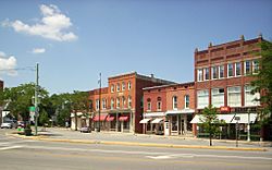
East Main Street, downtown
|
|

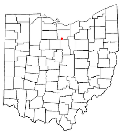
Location of Plymouth, Ohio
|
|

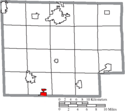
Location of Plymouth in Huron County
|
|
| Country | United States |
| State | Ohio |
| Counties | Richland, Huron |
| Area | |
| • Total | 2.56 sq mi (6.63 km2) |
| • Land | 2.53 sq mi (6.55 km2) |
| • Water | 0.03 sq mi (0.08 km2) |
| Elevation | 1,014 ft (309 m) |
| Population
(2020)
|
|
| • Total | 1,707 |
| • Density | 675.50/sq mi (260.80/km2) |
| Time zone | UTC-5 (Eastern (EST)) |
| • Summer (DST) | UTC-4 (EDT) |
| ZIP code |
44865
|
| Area code(s) | 419 |
| FIPS code | 39-63800 |
| GNIS feature ID | 2398988 |
| Website | http://www.plymouthoh.org/ |
Plymouth is a small village located in the state of Ohio, United States. It is unique because it sits across two different counties: Huron and Richland. In 2020, about 1,707 people lived here.
The part of Plymouth in Richland County is considered part of the larger Mansfield city area. The Huron County part is closer to the smaller Norwalk area.
Contents
History of Plymouth
Plymouth was first planned out in 1825. The village got its name from Plymouth Rock, a famous landmark. It officially became a village in 1834.
Plymouth Locomotive Works
For many years, Plymouth was home to the Plymouth Locomotive Works. This company built large industrial railroad locomotives. These are like powerful engines used to pull trains, especially in factories or mines. The factory closed its doors in 1999.
Interestingly, this company also designed and built an automobile called Plymouth a long time ago. It wasn't mass-produced like cars today. They also made trucks and tractors under the Plymouth name. Later, Chrysler Motors started their own "Plymouth Automobile Division." There was a legal fight over who owned the name "Plymouth." Chrysler lost because the Ohio company's car came out first.
Geography of Plymouth
Plymouth is located at coordinates 40.996121 degrees North and -82.666746 degrees West.
Land and Water Area
According to the United States Census Bureau, the village covers a total area of about 2.50 square miles (6.47 square kilometers). Most of this area, about 2.47 square miles (6.40 square kilometers), is land. A small part, about 0.03 square miles (0.08 square kilometers), is water.
Divided by a Road
The main east-west street in downtown Plymouth is called East Main and West Broadway. Outside the village, this road is known as Base Line Road. This road is important because it marks the border between Richland and Huron counties.
This means the village is split between two different political areas. This can cause some challenges with things like taxes and local laws. Plymouth has its own police force. However, one half of the village is also under the authority of the Huron County Sheriff's Department, and the other half is under the Richland County Sheriff's Department.
Population and People
| Historical population | |||
|---|---|---|---|
| Census | Pop. | %± | |
| 1860 | 462 | — | |
| 1870 | 703 | 52.2% | |
| 1880 | 1,145 | 62.9% | |
| 1890 | 1,133 | −1.0% | |
| 1900 | 1,154 | 1.9% | |
| 1910 | 1,314 | 13.9% | |
| 1920 | 1,374 | 4.6% | |
| 1930 | 1,339 | −2.5% | |
| 1940 | 1,403 | 4.8% | |
| 1950 | 1,510 | 7.6% | |
| 1960 | 1,822 | 20.7% | |
| 1970 | 1,993 | 9.4% | |
| 1980 | 1,939 | −2.7% | |
| 1990 | 1,942 | 0.2% | |
| 2000 | 1,852 | −4.6% | |
| 2010 | 1,857 | 0.3% | |
| 2020 | 1,707 | −8.1% | |
| Sources: | |||
2010 Population Data
In 2010, the census showed that 1,857 people lived in Plymouth. There were 696 households, which are groups of people living together. About 499 of these were families. The village had about 751.8 people per square mile (290.3 people per square kilometer).
Most of the people living in Plymouth were White (97.6%). A small number were African American, Native American, or Asian. About 2.5% of the population identified as Hispanic or Latino.
Households and Age
Out of all the households, 40.4% had children under 18 living with them. About 47.6% were married couples. Some households had a female head without a husband (18.1%), or a male head without a wife (6.0%). About 28.3% were not families.
The average household had 2.67 people, and the average family had 3.13 people. The median age in the village was 34.1 years old. This means half the people were younger than 34.1, and half were older. About 29.5% of residents were under 18. About 13.3% were 65 years old or older.
Education in Plymouth
Plymouth is part of the Plymouth-Shiloh Local School District. This school district runs three public schools in the village. These include Plymouth-Shiloh Elementary School, Shiloh Middle School, and Plymouth High School.
The village also has a public library. It is a branch of the Mansfield–Richland County Public Library system.
Entertainment and Culture
Plymouth had its first movie theater in the mid-1910s. It was opened by Reuben Deisler and was called the Deisler Theatre. This theater even got national attention because its owner, Reuben Deisler, was completely blind! The building was still standing in 2009.
Notable People from Plymouth
- David Ross Locke: A journalist and political writer during the American Civil War.
- Eleanor Searle Whitney McCollum: She was married to Cornelius Vanderbilt Whitney and started the Heritage Center Museum.
- John M. C. Smith: A U.S. Representative who served the state of Michigan.
See also
 In Spanish: Plymouth (Ohio) para niños
 | Emma Amos |
 | Edward Mitchell Bannister |
 | Larry D. Alexander |
 | Ernie Barnes |

