Ottawa County, Ohio facts for kids
Quick facts for kids
Ottawa County
|
|||
|---|---|---|---|

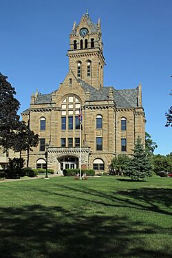
Ottawa County Courthouse
|
|||
|
|||

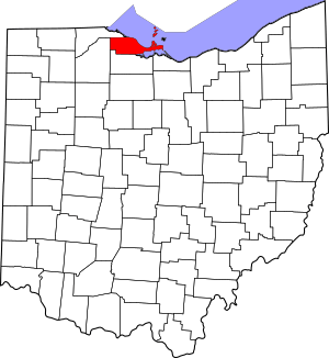
Location within the U.S. state of Ohio
|
|||
 Ohio's location within the U.S. |
|||
| Country | |||
| State | |||
| Founded | March 6, 1840 | ||
| Named for | the Ottawa tribe or a word meaning "trader" | ||
| Seat | Port Clinton | ||
| Largest city | Port Clinton | ||
| Area | |||
| • Total | 585 sq mi (1,520 km2) | ||
| • Land | 255 sq mi (660 km2) | ||
| • Water | 330 sq mi (900 km2) 56%% | ||
| Population
(2020)
|
|||
| • Total | 40,364 |
||
| • Density | 158/sq mi (61/km2) | ||
| Time zone | UTC−5 (Eastern) | ||
| • Summer (DST) | UTC−4 (EDT) | ||
| Congressional district | 9th | ||
Ottawa County is a county located in the northwestern part of the U.S. state of Ohio. As of the 2020 census, about 40,364 people lived there. Its county seat (the main town for county government) is Port Clinton. The county is named either for the Ottawa (Odawa) Indigenous peoples who lived there, or for an Indigenous word meaning "trader."
Ottawa County is part of the Port Clinton, OH Micropolitan Statistical Area. This area is also included in the larger Toledo-Port Clinton, OH Combined Statistical Area.
Contents
History of Ottawa County
Early Events and Formation
A very important event happened near Ottawa County on September 10, 1813. During the War of 1812, nine ships from the United States Navy, led by Commodore Oliver Hazard Perry, fought against six ships from Great Britain’s Royal Navy. This battle, called the Battle of Lake Erie, took place near Put-in-Bay. The American forces won a big victory, which was a major moment in the war.
Ottawa County was officially created on March 6, 1840. It was formed from parts of Erie, Lucas, and Sandusky counties. As mentioned, it was named after the Ottawa (Odawa) Indigenous tribe of North America.
Historic Courthouse and Political Trends
In 1974, the Ottawa County Courthouse was added to the National Register of Historic Places. This means it is recognized as an important historical building.
The county is also known in presidential politics for being a "bellwether." This means that from 1964 to 2016, Ottawa County consistently voted for the candidate who ended up winning the presidential election. It was a good indicator of the national outcome for many years.
Geography of Ottawa County
According to the U.S. Census Bureau, Ottawa County covers a total area of 585 square miles. About 255 square miles of this is land, and 330 square miles (56%) is water. This makes it the third-smallest county in Ohio by land area. It shares a border with Ontario, Canada, across Lake Erie.
Neighboring Areas
Ottawa County is surrounded by several other counties and even another country:
- Essex County, Ontario, Canada (to the northeast)
- Erie County (to the southeast)
- Sandusky County (to the south)
- Wood County (to the west)
- Lucas County (to the northwest)
Protected Natural Areas
Ottawa County is home to important natural and historical sites:
- Ottawa National Wildlife Refuge (part of it is in the county)
- Perry's Victory and International Peace Memorial
Population of Ottawa County
| Historical population | |||
|---|---|---|---|
| Census | Pop. | %± | |
| 1840 | 2,248 | — | |
| 1850 | 3,308 | 47.2% | |
| 1860 | 7,016 | 112.1% | |
| 1870 | 13,364 | 90.5% | |
| 1880 | 19,762 | 47.9% | |
| 1890 | 21,974 | 11.2% | |
| 1900 | 22,213 | 1.1% | |
| 1910 | 22,360 | 0.7% | |
| 1920 | 22,193 | −0.7% | |
| 1930 | 24,109 | 8.6% | |
| 1940 | 24,360 | 1.0% | |
| 1950 | 29,469 | 21.0% | |
| 1960 | 35,323 | 19.9% | |
| 1970 | 37,099 | 5.0% | |
| 1980 | 40,076 | 8.0% | |
| 1990 | 40,029 | −0.1% | |
| 2000 | 40,985 | 2.4% | |
| 2010 | 41,428 | 1.1% | |
| 2020 | 40,364 | −2.6% | |
| U.S. Decennial Census 1790-1960 1900-1990 1990-2000 2020 |
|||
As of the 2010 United States Census, there were 41,428 people living in Ottawa County. Most of the people (96.5%) were white. About 4.2% of the population identified as Hispanic or Latino. The average age of people in the county was 46.3 years old.
Transportation in Ottawa County
Major Roads
Eight major highways run through Ottawa County. These include two interstates (large national highways) and several state routes.
 Interstate 80 (Ohio Turnpike)
 Interstate 90 (Ohio Turnpike)
 Ohio State Route 2
 Ohio State Route 19
 Ohio State Route 51
 Ohio State Route 53
 Ohio State Route 105
 Ohio State Route 163
 Ohio State Route 269
 Ohio State Route 590
Airports
Ottawa County has several airports, many of which serve the islands in Lake Erie:
- Erie-Ottawa Regional Airport
- Middle Bass-East Point Airport
- Middle Bass Island Airport
- North Bass Island Airport
- Put-in-Bay Airport
Communities in Ottawa County
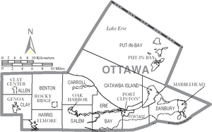
Ottawa County has one city, several villages, and many townships and smaller communities.
City
- Port Clinton (This is the county seat, where the main government offices are.)
Villages
Townships
- Allen
- Bay
- Benton
- Carroll
- Catawba Island
- Clay
- Danbury
- Erie
- Harris
- Portage
- Put-in-Bay
- Salem
Census-designated places
These are areas that are like towns but are not officially incorporated as cities or villages.
Unincorporated communities
These are smaller communities that are not part of any city or village government.
- Catawba Island
- Danbury
- Elliston
- Forest Park
- Graytown
- Gypsum
- Isle St. George
- Lacarne
- Limestone
- Martin
- Middle Bass
Notable Residents
- Louis C. Shepard - He was a recipient of the Medal of Honor during the American Civil War. He is buried in Lakeview cemetery in Port Clinton, Ohio.
- Crystal Bowersox - A singer-songwriter who was the runner-up on the TV show American Idol.
See also
 In Spanish: Condado de Ottawa (Ohio) para niños
 | Bayard Rustin |
 | Jeannette Carter |
 | Jeremiah A. Brown |


