Congress Lands facts for kids
The Congress Lands were special areas of land in Ohio that the United States government sold to people. These lands were made available through special offices in different cities, including the General Land Office.
The Congress Lands were divided into three main groups for surveying:
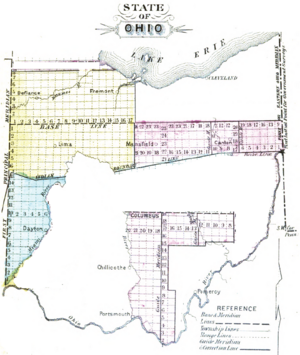
- The Ohio River Base
- Congress Lands West of Miami River
- Northwest Ohio
- North and East of the First Principal Meridian
- South and East of the First Principal Meridian
Contents
Ohio River Base: How Land Was Measured
The Ohio River Base included the Congress Lands East of the Scioto River and the Congress Lands North of the Old Seven Ranges. In these areas, land was measured using a system of "ranges" and "townships."
Ranges and Townships
- Ranges were like vertical columns of land, each six miles wide.
- Townships were square areas of land, six miles by six miles, found within these ranges.
These ranges were numbered starting from a line called Ellicott’s Line. This line was the border between Ohio and Pennsylvania. It was also known as the Eastern Ohio Meridian.
Starting Points for Surveys
The townships within each range were measured north and south from a main starting line. This line was called the “Geographer’s Line.” It ran west from the north bank of the Ohio River, right where it leaves Pennsylvania. This spot is now known as the Beginning Point of the U.S. Public Land Survey.
Townships were numbered from south to north. The first partial township next to the Ohio River was number one. This meant that townships in different ranges often had different numbers, even if they were next to each other. This system continued the way land was numbered in the original Seven Ranges.
Land plots in this area were often described as “Township X of Range Y of Ohio River Survey.” There was no need to add "north" or "west" because of how they were numbered. Other lands, like those from the Ohio Company and the Seven Ranges, were also sold this way. The Seven Ranges are often considered Congress Lands but have their own special category.
Congress Lands West of Miami River
The Congress Lands West of the Miami River were located between the Great Miami River and the state of Indiana. They were also south of the Greenville Treaty Line.
Measuring West of Miami
In this area, the ranges were measured east from the First Principal Meridian. This meridian is a key north-south survey line located at the Ohio-Indiana border. Townships were numbered from south to north. Sometimes, the path of the Great Miami River caused some numbering to be a bit uneven.
Northwest Ohio: A Big Area
The Congress Lands in northwest Ohio covered a large area. They included lands both north and south of a main east-west line, and east of the First Principal Meridian.
Location Details
These lands were:
- South of a narrow strip of land near the Michigan border.
- West of the Firelands and the Congress Lands North of Old Seven Ranges.
- North of the Greenville Treaty Line and the Virginia Military District.
- East of Indiana.
How Townships Were Named
Townships in northwest Ohio were measured north and south from a baseline at 41 degrees north latitude. They were named in a specific way, for example:
- “Township X N, Range Y E of First Principal Meridian” (for townships north of the baseline).
- “Township X S, Range Y E of First Principal Meridian” (for townships south of the baseline).
Township Subdivision: Smaller Pieces of Land

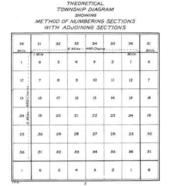
In all five of Ohio’s Congress Lands, each six-mile square township was divided into 36 smaller areas. These smaller areas were called sections, and each section was one mile square.
Numbering Sections
The sections were numbered using a system that started on May 18, 1796. Section sixteen of every township was special. It was set aside to help pay for and support public schools. This was an important way to fund education as new areas were settled.
Other Lands for Sale
Some lands that were not sold in the United States Military District or the Refugee Tract were also made available. These lands were sold through the same Land Offices and treated just like the Congress Lands.
 | Bessie Coleman |
 | Spann Watson |
 | Jill E. Brown |
 | Sherman W. White |


