Michigan meridian facts for kids
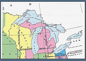
The Michigan meridian is a very important imaginary line that runs north and south through the state of Michigan. Think of it like a starting line for mapping out land. It was used during the Michigan Survey, which was a big project in the early 1800s to measure and map all the land in Michigan. This line is located at about 84 degrees west longitude, which is a way to measure how far east or west a place is on Earth.
Contents
How the Michigan Meridian Was Created
This special line was first measured by a person named Benjamin Hough in April 1815. It was chosen because it was a key boundary line mentioned in the Treaty of Detroit from 1807. This treaty was a very important agreement where Native American groups gave up a large amount of land to the United States in what was then the Michigan Territory. The treaty said the boundary line would go straight north from the mouth of the Auglaize River on the Maumee River. This spot is where Fort Defiance (now Defiance, Ohio) is located.
The Michigan Baseline
At the same time the Michigan meridian was surveyed, another important line called Michigan's baseline was also measured. This baseline runs east and west. Today, it forms the northern border for several counties like Wayne and Washtenaw. This baseline was surveyed by Alexander Holmes. It was meant to be exactly 78 miles north of Fort Defiance.
Even though later rules for mapping land in the U.S. said that baselines should be perfectly straight east-west lines (called a true parallel of latitude), this wasn't always the case in earlier surveys, including Michigan's. Some roads were built along both the meridian and the baseline. You can still find parts of the Michigan Meridian that are called Meridian Road.
Where the Meridian Is Today
The Michigan meridian acts as a border between many counties in Michigan. For example, it separates Lenawee and Hillsdale counties. It also divides Shiawassee and Clinton, and many others further north.
A major road, U.S. Highway 127, follows the meridian pretty closely from the Ohio border up to Jackson. In Okemos, there's even a historic area called Meridian, which is right on the line. Both Okemos and this area are part of Meridian Township. Other state highways, like M-30 and M-129, are also known as Meridian Road in some places.
The Toledo Strip and Land Surveying
There was an area of land called the Toledo Strip that was once thought to be part of the Michigan Territory. Because of this, the land in that area was measured using the Michigan meridian and baseline. This is why the townships there are numbered based on Michigan's survey system.
When Indiana became a state in 1816, it was given a 10-mile wide strip of land. This land hadn't been surveyed yet, so the Indiana part was measured with the rest of Indiana. However, in Michigan, the very southernmost townships (groups of land) were made a bit smaller than usual. Instead of being the standard 6 miles by 6 miles, some were only 6 miles by 3.5 miles. This meant that some sections of land within these townships were cut in half or didn't exist at all. To make up for this, some towns were given extra land from nearby townships. This happened in places like White Pigeon Township and Three Oaks Township. Other smaller townships were combined with their neighbors. This is why many towns along Michigan's border with Ohio are not exactly 36 square miles in size.
 | William L. Dawson |
 | W. E. B. Du Bois |
 | Harry Belafonte |


