Clinton County, Michigan facts for kids
Quick facts for kids
Clinton County
|
|||
|---|---|---|---|

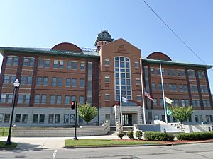
Clinton County Courthouse in St. Johns
|
|||
|
|||

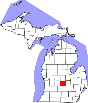
Location within the U.S. state of Michigan
|
|||
 Michigan's location within the U.S. |
|||
| Country | |||
| State | |||
| Founded | 1831 | ||
| Named for | DeWitt Clinton | ||
| Seat | St. Johns | ||
| Largest city | St. Johns | ||
| Area | |||
| • Total | 574 sq mi (1,490 km2) | ||
| • Land | 566 sq mi (1,470 km2) | ||
| • Water | 8.1 sq mi (21 km2) 1.4%% | ||
| Population
(2020)
|
|||
| • Total | 79,128 | ||
| • Estimate
(2023)
|
79,720 |
||
| • Density | 137.85/sq mi (53.23/km2) | ||
| Time zone | UTC−5 (Eastern) | ||
| • Summer (DST) | UTC−4 (EDT) | ||
| Congressional district | 7th | ||
Clinton County is a county in the state of Michigan. It's like a special area within the state. In 2020, about 79,128 people lived here. The main town, or county seat, is St. Johns.
The county was created in 1831. It officially started working in 1839. It got its name from an important early American leader, DeWitt Clinton. Clinton County is part of the larger Lansing-East Lansing area. This means it's connected to those bigger cities nearby.
Contents
Where is Clinton County?
Clinton County is located in Michigan. It covers a total area of about 575 square miles. Most of this area, about 566 square miles, is land. The rest, about 8.1 square miles, is water. That's about 1.4% of the total area.
Neighboring Counties
Clinton County shares its borders with several other counties. Think of them as its neighbors.
- Saginaw County is to the northeast.
- Gratiot County is to the north.
- Montcalm County is to the northwest.
- Shiawassee County is to the east.
- Ionia County is to the west.
- Ingham County is to the southeast.
- Eaton County is to the southwest.
Who Lives in Clinton County?
Over the years, more and more people have moved to Clinton County. In 1840, only 1,614 people lived there. By 2020, the population had grown to 79,128. This shows how much the county has developed.
| Historical population | |||
|---|---|---|---|
| Census | Pop. | %± | |
| 1840 | 1,614 | — | |
| 1850 | 5,102 | 216.1% | |
| 1860 | 13,916 | 172.8% | |
| 1870 | 22,845 | 64.2% | |
| 1880 | 28,100 | 23.0% | |
| 1890 | 26,509 | −5.7% | |
| 1900 | 25,136 | −5.2% | |
| 1910 | 23,129 | −8.0% | |
| 1920 | 23,110 | −0.1% | |
| 1930 | 24,174 | 4.6% | |
| 1940 | 26,671 | 10.3% | |
| 1950 | 31,195 | 17.0% | |
| 1960 | 37,969 | 21.7% | |
| 1970 | 48,492 | 27.7% | |
| 1980 | 55,893 | 15.3% | |
| 1990 | 57,883 | 3.6% | |
| 2000 | 64,753 | 11.9% | |
| 2010 | 75,382 | 16.4% | |
| 2020 | 79,128 | 5.0% | |
| 2023 (est.) | 79,720 | 5.8% | |
| U.S. Decennial Census 1790-1960 1900-1990 1990-2000 2010-2018 |
|||
In 2000, there were about 64,753 people living in the county. Most people in Clinton County are White. A smaller number are Black, Native American, or Asian. Some people are also of Hispanic or Latino background. Most people speak English at home.
The average age of people in the county in 2000 was 37 years old. About 28% of the population was under 18. This means there are many young people and families living here.
Getting Around Clinton County
Clinton County has several important roads and airports. These help people travel easily.
Highways
Many major highways pass through or near Clinton County:
 I-69 goes through the southern part of the county. It connects to cities like Battle Creek and Flint.
 I-96 runs through the southwest corner. It links Grand Rapids to the west and Detroit to the east.
 US 127 goes north and south through the middle of the county. It serves towns like St. Johns and DeWitt.
 M-21 travels east and west. It connects to Grand Rapids and Flint.
Airports
There are two main airports near Clinton County:
- Capital Region International Airport (LAN) is a public airport. It's located northwest of downtown Lansing. It's about 3 miles (5 km) away.
- Abrams Municipal Airport (4D0) is a smaller public airport. It's located north of Grand Ledge.
Towns and Villages
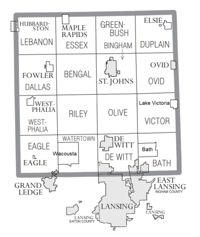
Clinton County has several cities, villages, and townships. These are different types of communities where people live.
Cities
- DeWitt
- East Lansing (part of it is in Clinton County)
- Grand Ledge (part of it is in Clinton County)
- Lansing (part of it is in Clinton County)
- Ovid (part of it is in Clinton County)
- St. Johns (This is the main town, or county seat)
Villages
- Eagle
- Elsie
- Fowler
- Hubbardston (part of it is in Clinton County)
- Maple Rapids
- Westphalia
Townships
Townships are smaller areas, often with both rural and suburban parts.
- Bath Charter Township
- DeWitt Charter Township
- Watertown Charter Township
- Bengal Township
- Bingham Township
- Dallas Township
- Duplain Township
- Eagle Township
- Essex Township
- Greenbush Township
- Lebanon Township
- Olive Township
- Ovid Township
- Riley Township
- Victor Township
- Westphalia Township
Other Places
There are also smaller communities that are not officially cities or villages:
- Bath
- Eureka
- Lake Victoria
- Wacousta
- Gunnisonville
- Matherton (part of it is in Clinton County)
- Shepardsville
See also
 In Spanish: Condado de Clinton (Míchigan) para niños
 | Tommie Smith |
 | Simone Manuel |
 | Shani Davis |
 | Simone Biles |
 | Alice Coachman |


