
Maple Rapids, Michigan facts for kids
Quick facts for kids
Maple Rapids, Michigan
|
|
|---|---|
|
Village
|
|
| Village of Maple Rapids | |
.jpg)
Intersection of Main Street and Maple Avenue
|
|

Location within Clinton County
|
|

Maple Rapids, Michigan
Location in Michigan

Maple Rapids, Michigan
Location in the United States
|
|
| Country | |
| State | |
| County | |
| Township | Essex |
| Settled | 1852 |
| Incorporated | 1881 |
| Government | |
| • Type | Village council |
| Area | |
| • Total | 1.43 sq mi (3.69 km2) |
| • Land | 1.37 sq mi (3.54 km2) |
| • Water | 0.06 sq mi (0.15 km2) |
| Elevation | 666 ft (203 m) |
| Population
(2020)
|
|
| • Total | 573 |
| • Density | 419.47/sq mi (161.91/km2) |
| Time zone | UTC-5 (Eastern (EST)) |
| • Summer (DST) | UTC-4 (EDT) |
| ZIP code(s) |
48853
|
| Area code(s) | 989 |
| FIPS code | 26-51200 |
| GNIS feature ID | 2399248 |
Maple Rapids is a small village located in Clinton County, which is part of the U.S. state of Michigan. In 2010, about 672 people lived here. The village is found within Essex Township. It is about 10 kilometers (6 miles) northwest of St. Johns. A part of Maple Rapids is even inside the Maple River State Game Area, which is a place for wildlife.
Contents
Discovering Maple Rapids' Past
In the early 1800s, the area now known as Maple Rapids was a special spot. A leader named Maketoquit and his large group of Ottawa people used to come here. They would make maple sugar from the trees. Their main home was further east, in what is now Shiawassee County, Michigan.
The name "Maple Rapids" comes from the fast-moving parts of the Maple River. George Campau named it in 1826. George was the brother of Louis Campau, who founded Grand Rapids. George built a trading post here, which was a place where people could trade goods.
Later, in 1852, a man named William Hewitt built a dam on the river. He also built a sawmill to cut wood and a store. He planned out the land for the town and became the first postmaster. The town officially became a village in 1881. This happened during a time when cutting and selling lumber was a big business.
Where is Maple Rapids Located?
Maple Rapids is a small place. According to the U.S. Census Bureau, the village covers about 3.68 square kilometers (1.42 square miles). Most of this area is land, about 3.52 square kilometers (1.36 square miles). A small part, about 0.15 square kilometers (0.06 square miles), is water. This water makes up about 4.23% of the village's total area.
Who Lives in Maple Rapids?
| Historical population | |||
|---|---|---|---|
| Census | Pop. | %± | |
| 1880 | 605 | — | |
| 1890 | 533 | −11.9% | |
| 1900 | 579 | 8.6% | |
| 1910 | 529 | −8.6% | |
| 1920 | 466 | −11.9% | |
| 1930 | 476 | 2.1% | |
| 1940 | 580 | 21.8% | |
| 1950 | 645 | 11.2% | |
| 1960 | 683 | 5.9% | |
| 1970 | 683 | 0.0% | |
| 1980 | 683 | 0.0% | |
| 1990 | 680 | −0.4% | |
| 2000 | 643 | −5.4% | |
| 2010 | 672 | 4.5% | |
| 2020 | 573 | −14.7% | |
| U.S. Decennial Census | |||
Village Population in 2010
In 2010, a count called the census showed that 672 people lived in Maple Rapids. These people lived in 251 homes, and 186 of these were families.
Most people in the village were White, making up about 97.5% of the population. A small number of people were African American, Native American, or Asian. About 1.6% of residents were from two or more racial backgrounds. Around 1.5% of the population identified as Hispanic or Latino.
Many homes had children under 18 living there, about 41%. More than half of the homes, 55.4%, were married couples living together. The average home had about 2.68 people.
The average age of people in the village was 36.7 years old. About 27.8% of the residents were under 18 years old. Around 12.2% of the people were 65 years old or older. The village had a nearly even number of males and females, with 51.0% male and 49.0% female.
Images for kids
-
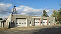
Maple Rapids Municipal Building
-
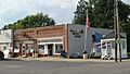
U.S. Post Office in Maple Rapids
-
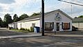
Maple Rapids Public Library


See also
 In Spanish: Maple Rapids para niños
