Ingham County, Michigan facts for kids
Quick facts for kids
Ingham County
|
|||
|---|---|---|---|

|
|||
|
|||

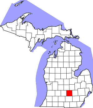
Location within the U.S. state of Michigan
|
|||
 Michigan's location within the U.S. |
|||
| Country | |||
| State | |||
| Founded | October 29, 1829 (created) 1838 (organized) |
||
| Named for | Samuel D. Ingham | ||
| Seat | Mason | ||
| Largest city | Lansing | ||
| Area | |||
| • Total | 561 sq mi (1,450 km2) | ||
| • Land | 556 sq mi (1,440 km2) | ||
| • Water | 4.6 sq mi (12 km2) 0.8%% | ||
| Population
(2020)
|
|||
| • Total | 284,900 | ||
| • Estimate
(2023)
|
284,637 |
||
| • Density | 507.8/sq mi (196.08/km2) | ||
| Time zone | UTC−5 (Eastern) | ||
| • Summer (DST) | UTC−4 (EDT) | ||
| Congressional district | 7th | ||
Ingham County is a county in the state of Michigan. It's a place where many people live, work, and go to school. In 2020, about 284,900 people called Ingham County home.
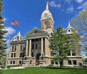
The main office for the county government, called the county seat, is in the city of Mason. A big part of Lansing, which is Michigan's state capital, is also in Ingham County. Interestingly, Lansing is the only state capital in the U.S. that isn't also the county seat of its own county!
Ingham County is a lively place. It's home to Michigan State University, a large college, and Lansing Community College. You can also cheer for the Lansing Lugnuts, a minor league baseball team. The county is part of the larger Lansing–East Lansing area and is considered part of Mid Michigan.
Contents
History of Ingham County
Ingham County was officially created on October 29, 1829. This happened when the Michigan government decided to use parts of other counties to form it. For a few years, it was managed by Washtenaw County. But in 1838, Ingham County got its own local government.
The county was named after Samuel D. Ingham. He was an important person who worked for the U.S. government as the Secretary of the Treasury under President Andrew Jackson. Ingham County is one of Michigan's "Cabinet counties," meaning it's named after a member of a president's cabinet.
Geography and Natural Features
Ingham County covers a total area of about 561 square miles. Most of this area, about 556 square miles, is land. The rest, about 4.6 square miles, is water.
The county has gentle, rolling hills. The land usually sits between 800 and 1,000 feet above sea level. The highest spot in the county is Teaspoon Hill, which is 1,056 feet high. It's located about 1.5 miles north of Leslie.
Two important rivers flow through Ingham County. The Grand River flows along the western edge. The Red Cedar River flows west across the northern part of the county and joins the Grand River in Lansing. Many smaller streams and rivers also help drain the land. For example, Sycamore Creek flows into the Red Cedar River in Lansing.
Neighboring Counties
Ingham County shares its borders with several other counties:
- Shiawassee County (to the northeast)
- Livingston County (to the east)
- Washtenaw County (to the southeast)
- Jackson County (to the south)
- Eaton County (to the west)
- Clinton County (to the north)
Population and People
| Historical population | |||
|---|---|---|---|
| Census | Pop. | %± | |
| 1840 | 2,498 | — | |
| 1850 | 8,631 | 245.5% | |
| 1860 | 17,435 | 102.0% | |
| 1870 | 25,268 | 44.9% | |
| 1880 | 33,676 | 33.3% | |
| 1890 | 37,666 | 11.8% | |
| 1900 | 39,818 | 5.7% | |
| 1910 | 53,310 | 33.9% | |
| 1920 | 81,554 | 53.0% | |
| 1930 | 116,587 | 43.0% | |
| 1940 | 130,616 | 12.0% | |
| 1950 | 172,941 | 32.4% | |
| 1960 | 211,296 | 22.2% | |
| 1970 | 261,039 | 23.5% | |
| 1980 | 275,520 | 5.5% | |
| 1990 | 281,912 | 2.3% | |
| 2000 | 279,320 | −0.9% | |
| 2010 | 280,895 | 0.6% | |
| 2020 | 284,900 | 1.4% | |
| 2023 (est.) | 284,637 | 1.3% | |
| U.S. Decennial Census 1790–1960 1900–1990 1990–2000 2010-2019 |
|||
In 2010, about 280,895 people lived in Ingham County. The county is quite diverse. About 76.2% of the people were White, 11.8% were Black or African American, and 5.2% were Asian. About 7.83% of the population identified as Hispanic or Latino.
Many people in Ingham County have German, Irish, or English backgrounds. Most people in the county speak English at home.
Getting Around Ingham County
There are many ways to travel in and out of Ingham County.
Air Travel
- You can fly from Capital Region International Airport in Lansing.
- There's also a smaller airport called Mason Jewett Field.
Train Service
- Amtrak provides passenger train service.
- Freight trains are operated by Canadian National Railway, CSX Transportation, and Jackson & Lansing Railroad.
Bus Service
- Local buses are run by the Capital Area Transportation Authority (CATA).
- Long-distance bus services include Greyhound Lines and Indian Trails.
Major Roads
Many important highways cross Ingham County, making it easy to drive around.
 I-96
I-96 BL I-96
 I-496
I-496 BL I-69
 US 127
 M-36
M-36 M-43
M-43 M-52
M-52 M-99
M-99- M-106
- M-143
- M-188
Recreational Trails
- The Lansing River Trail is a great place for walking, running, and biking.
Communities in Ingham County
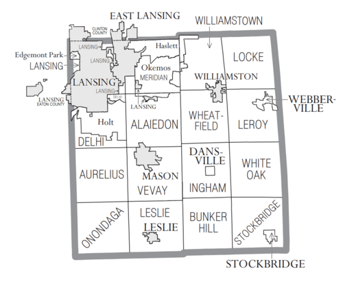
Ingham County has several cities, villages, and townships.
Cities
- East Lansing (part of it)
- Lansing (part of it)
- Leslie
- Mason (This is the county seat!)
- Williamston
Villages
Charter Townships
These are special types of townships with more local control.
- Delhi Charter Township
- Lansing Charter Township
- Meridian Charter Township
Civil Townships
- Alaiedon Township
- Aurelius Township
- Bunker Hill Township
- Ingham Township
- Leroy Township
- Leslie Township
- Locke Township
- Onondaga Township
- Stockbridge Township
- Vevay Township
- Wheatfield Township
- White Oak Township
- Williamstown Township
Other Communities
These are smaller, unincorporated places:
Education in Ingham County
Ingham County has many different school districts that serve its students.
- Dansville Schools
- East Lansing School District
- Eaton Rapids Public Schools
- Fowlerville Community Schools
- Haslett Public Schools
- Holt Public Schools
- Lansing Public School District
- Leslie Public Schools
- Mason Public Schools
- Morrice Area Schools
- Northwest School District
- Okemos Public Schools
- Perry Public School District
- Springport Public Schools
- Stockbridge Community Schools
- Waverly Community Schools
- Webberville Community Schools
- Williamston Community Schools
Michigan State University, a very large university, is also located in Ingham County.
See also
 In Spanish: Condado de Ingham para niños
 | Chris Smalls |
 | Fred Hampton |
 | Ralph Abernathy |


