Williamstown Township, Michigan facts for kids
Quick facts for kids
Williamstown Township, Michigan
|
|
|---|---|

|
|
| Country | United States |
| State | Michigan |
| County | Ingham |
| Organized | 1839 |
| Area | |
| • Total | 29.26 sq mi (75.78 km2) |
| • Land | 29.09 sq mi (75.34 km2) |
| • Water | 0.17 sq mi (0.44 km2) |
| Elevation | 922 ft (281 m) |
| Population
(2020)
|
|
| • Total | 5,286 |
| • Density | 180.66/sq mi (69.755/km2) |
| Time zone | UTC-5 (Eastern (EST)) |
| • Summer (DST) | UTC-4 (EDT) |
| FIPS code | 26-87440 |
| GNIS feature ID | 1627275 |
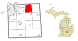
Williamstown Township is a special type of local government area called a civil township. It is located in Ingham County in the U.S. state of Michigan. In 2020, about 5,286 people lived there. The city of Williamston is in the southeast part of the township. Even though they are close, Williamstown Township and Williamston City are managed separately.
Contents
Places in Williamstown Township
Williamstown Township is home to a few interesting communities.
Africa: A Place of Strong Beliefs
- Africa was a part of Williamstown Township. It was settled by the Webb family. They were very strong abolitionists, meaning they were against slavery. Other people in the area started calling their home "Africa" because of their views.
Alverson: A Historic Post Office
- Alverson was once the name of a post office in Williamstown Township. Samuel Alverson owned a lot of land and became the first postmaster in September 1852. His home was the post office! It closed and reopened a few times before closing for good in January 1896.
Haslett and Okemos: Nearby Communities
- Haslett is a community that is not officially a city. It is also a census-designated place (CDP), which means it's an area the U.S. Census Bureau defines for gathering population data. A small part of Haslett extends into Williamstown Township.
- Okemos is another unincorporated community and CDP. A small part of Okemos also reaches into the northern area of Williamstown Township.
Geography of Williamstown Township
Williamstown Township covers an area of about 29.26 square miles (75.78 km2). Most of this area, about 29.09 square miles (75.34 km2), is land. The rest, about 0.17 square miles (0.44 km2), is water. This means only a small part of the township is covered by water.
Who Lives in Williamstown Township?
In 2000, there were 4,834 people living in Williamstown Township. Most people lived in families, with many married couples. About 40% of households had children under 18 living with them. The average household had about 2.85 people.
The population included people of different ages:
- About 28.9% were under 18 years old.
- About 32.7% were between 45 and 64 years old.
- About 9.1% were 65 years or older.
The average age in the township was 41 years old.
Most families in the township had a good income. The average income for a family was about $86,169. Only a small number of families and people lived below the poverty line.
Schools in the Township
Most students in Williamstown Township attend schools in the Williamston Community Schools district. However, some parts of the township are served by other school districts. These include Haslett Public Schools, Okemos Public Schools, and Perry Public Schools.
Major Roads and Highways
Several important roads are near or run through Williamstown Township. These highways help people travel to and from the area.
 I-96 is a major highway that runs east–west. It is about one mile (1.6 km) south of the township's southern border.
 M-43 also runs east–west through the southern part of the township.
 M-52 runs north–south. It is about two miles (3.2 km) east of the township's eastern border.
See also
 In Spanish: Municipio de Williamstown para niños
 | Isaac Myers |
 | D. Hamilton Jackson |
 | A. Philip Randolph |


