Aurelius Township, Michigan facts for kids
Quick facts for kids
Aurelius Township, Michigan
|
|
|---|---|

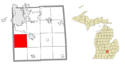
Location within Ingham County
|
|
| Country | United States |
| State | Michigan |
| County | Ingham |
| Established | 1837 |
| Area | |
| • Total | 36.47 sq mi (94.46 km2) |
| • Land | 36.41 sq mi (94.30 km2) |
| • Water | 0.06 sq mi (0.16 km2) |
| Elevation | 915 ft (279 m) |
| Population
(2020)
|
|
| • Total | 4,354 |
| • Density | 119.386/sq mi (46.094/km2) |
| Time zone | UTC-5 (Eastern (EST)) |
| • Summer (DST) | UTC-4 (EDT) |
| ZIP code(s) | |
| Area code(s) | 517 |
| FIPS code | 26-04240 |
| GNIS feature ID | 1625864 |
Aurelius Township is a special kind of local government area called a civil township. It is located in Ingham County in the state of Michigan, USA.
In 2020, about 4,354 people lived in Aurelius Township. This was a big jump from 3,525 people in 2010.
Contents
What is Aurelius Township?
A civil township is a local government unit. It helps manage things like roads, parks, and other services for people living in the area. Aurelius Township was officially started in 1837.
Who runs Aurelius Township?
The township has leaders who help it run smoothly. The main leader is called the Supervisor, and their name is Larry Silsby. There is also a Clerk, Tracy Ayres, who handles important records and paperwork.
Communities in Aurelius Township
Aurelius Township has a few smaller areas within it. These are often called "unincorporated communities," which means they don't have their own separate city government.
- Aurelius is one of these communities. You can find it at these coordinates: 42°31′27″N 84°31′20″W / 42.52417°N 84.52222°W.
- North Aurelius is another community in the township. Its coordinates are 42°34′55″N 84°32′35″W / 42.58194°N 84.54306°W.
Geography and Size of Aurelius Township
Aurelius Township covers a total area of about 36.47 square miles (94.46 square kilometers). Most of this area is land, about 36.41 square miles (94.30 square kilometers). A very small part, about 0.06 square miles (0.16 square kilometers), is water.
Where is Aurelius Township located?
The township is in Ingham County, which is in the middle of Michigan. It's part of the wider Lansing–East Lansing metropolitan area.
Population and People
In 2020, the population of Aurelius Township was 4,354 people. This means that more people are choosing to live in the township.
How diverse is Aurelius Township?
According to information from 2000, most people living in the township were White (96.50%). There were also smaller groups of African American, Native American, and Asian residents. About 3.62% of the population identified as Hispanic or Latino.
What are the households like?
In 2000, there were 1,130 households in the township. Many of these were married couples living together. About 40% of households had children under 18 living with them. The average household had about 2.93 people.
See also
 In Spanish: Municipio de Aurelius (Míchigan) para niños
 | Bessie Coleman |
 | Spann Watson |
 | Jill E. Brown |
 | Sherman W. White |


