Red Cedar River (Michigan) facts for kids
Quick facts for kids Red Cedar River |
|
|---|---|

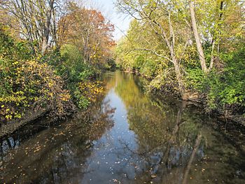
The Red Cedar River on the campus of Michigan State University in autumn
|
|

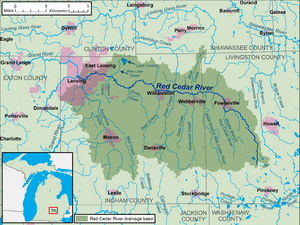
A map of the Red Cedar River and its watershed
|
|
| Country | United States |
| State | Michigan |
| Counties | Ingham, Livingston |
| Cities | Fowlerville, Williamston, Okemos, East Lansing, Lansing |
| Physical characteristics | |
| Main source | Cedar Lake Livingston County, Michigan, United States 42°31′03″N 83°58′42″W / 42.51750°N 83.97833°W |
| River mouth | Grand River Lansing, Michigan, United States 42°43′29″N 84°32′53″W / 42.72472°N 84.54806°W |
| Length | 51 mi (82 km) |
| Basin features | |
| Basin size | 461 sq mi (1,190 km2) |
The Red Cedar River is a river in central Michigan, United States. It flows into the Grand River. The Red Cedar River is about 51 miles (82 km) long. It drains an area of about 461 square miles (1,190 km²). This area includes the Lansing–East Lansing metropolitan area and nearby towns and farmlands.
Contents
What's in a Name?
The river likely got its name from a type of tree called the Juniperus virginiana. This tree is often called "red cedar" and grows naturally in the area.
For a long time, federal maps just called it the "Cedar River." But most people in Michigan knew it as the "Red Cedar River." In 1966, the United States Board on Geographic Names officially changed the name on maps to Red Cedar River. This was partly because of a letter from a state official. He mentioned how important the "Red Cedar" was to M.S.U. students. They even sing about it in their school song!
Where Does the River Flow?
The Red Cedar River starts at Cedar Lake in Livingston County. It flows for about 51 miles (82 km).
First, it travels northwest through Fowlerville. Then, it turns west and goes through Ingham County. In Ingham County, it passes through several towns. These include Williamston, Okemos, and East Lansing.
Finally, the river reaches Lansing. There, it joins the larger Grand River. A big part of the river's journey in East Lansing is right through the campus of Michigan State University.
The Red Cedar River is not very wide or deep. This means only small boats like canoes or kayaks can easily travel on it.
The River's Watershed
A watershed is an area of land where all the water drains into one river or lake. The Red Cedar River's watershed is about 461 square miles (1,190 km²) big.
Many smaller streams and creeks flow into the Red Cedar River. Some of the larger ones include Sycamore Creek and the stream from Lake Lansing.
The land in the watershed is a mix of different areas. There are farms and small towns, suburban neighborhoods, and busy city areas. Thousands of people live, learn, and work in this watershed. It's important to have farms, factories, and shopping areas. But it's also important to have clean water for fishing, swimming, and drinking. Natural areas are also key for beauty and wildlife. The river and its watershed are home to many plants and animals. They need a clean and safe environment to thrive.
How Clean is the Water?
The Clean Water Act was passed in 1972. Since then, the Red Cedar River has become much cleaner. Now, it's usually safe for swimming about 74% of the year. Sometimes, after heavy rains, the water might have higher levels of certain bacteria. This happens because rain washes pollution from the land into the river.
Michigan State University (MSU) regularly checks the river's water quality. They post reports about what they find. Even with improvements, littering is still a problem. People sometimes throw bikes, trash, and even old tires into the river.
To help with this, the MSU Fisheries and Wildlife club holds "Red Cedar Clean-Up" events twice a year. Students, teachers, and community members work together. They remove trash and recycle items found in and along the river.
The Red Cedar at Michigan State University
The Red Cedar River is a very well-known spot on the Michigan State University campus. It's even mentioned in the first line of MSU's fight song! Students often study or relax in the parks along its banks.
Over the years, many student activities have taken place on or near the river. In the past, there were "tug-o-war" games across the river between different student groups. There was also a Water Carnival with student-made floats. Many mallard ducks live near the river, and people on campus often feed them.
Right next to the river on campus is the W. J. Beal Botanical Garden. This garden started in 1873 and is the oldest continuously running botanical garden in the United States.
In the summer, the river is a popular place for canoeing and kayaking. There's even a canoe dock on campus. When the river floods, a special wave forms at the campus dam. Some people enjoy surfing this wave! In winter, the river often freezes. Students sometimes walk or play on the ice, but this can be dangerous. In 1922, the MSU hockey team even played games on the frozen river.
Fishing was not allowed on campus for many years. But in 2013, fishing was allowed again in a part of the river. The river is home to 33 different kinds of fish and many other water animals. Studying the river and its living things is part of what students learn at the university.
Images for kids
 | Georgia Louise Harris Brown |
 | Julian Abele |
 | Norma Merrick Sklarek |
 | William Sidney Pittman |


