Stockbridge Township, Michigan facts for kids
Quick facts for kids
Stockbridge Township, Michigan
|
|
|---|---|

|
|

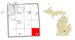
Location within Ingham County (red) and the administered village of Stockbridge (pink)
|
|
| Country | United States |
| State | Michigan |
| County | Ingham |
| Settled | 1834 |
| Established | 1836 |
| Area | |
| • Total | 35.92 sq mi (93.03 km2) |
| • Land | 35.46 sq mi (91.84 km2) |
| • Water | 0.46 sq mi (1.19 km2) |
| Elevation | 938 ft (286 m) |
| Population
(2020)
|
|
| • Total | 3,912 |
| • Density | 110.3/sq mi (42.6/km2) |
| Time zone | UTC-5 (Eastern (EST)) |
| • Summer (DST) | UTC-4 (EDT) |
| ZIP code(s) | |
| Area code(s) | 517 |
| FIPS code | 26-76580 |
| GNIS feature ID | 1627127 |
Stockbridge Township is a community located in Ingham County, Michigan, in the United States. It's a type of local government area called a civil township. In 2020, about 3,912 people lived here.
Contents
Exploring Stockbridge Township
- Stockbridge is a small village found in the southeast part of the township. Most of the township uses the Stockbridge 49285 ZIP Code.
A Look at Stockbridge Township's Past
The first person to settle in this area was David Rogers in 1834. As more people arrived, Stockbridge Township was officially created on November 26, 1836. It was the very first township in Ingham County.
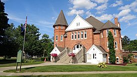
The village of Stockbridge was settled soon after and became the main place where people lived. The building that serves as the township hall today was built in Stockbridge in 1892. This historic building was added to the National Register of Historic Places in 1980. It was also recognized as a Michigan State Historic Site in 1987.
Where is Stockbridge Township?
Stockbridge Township covers about 35.92 square miles (93.03 square kilometers). Most of this area, about 35.46 square miles (91.84 square kilometers), is land. The rest, about 0.46 square miles (1.19 square kilometers), is water.
A fun place to visit is Lakelands Trail State Park. This park runs through part of the township. Its western end starts right in the village of Stockbridge.
How Many People Live Here?
In 2000, there were 3,435 people living in Stockbridge Township. These people lived in 1,220 households, and 941 of those were families. The population density was about 96.4 people per square mile.
About 37.6% of households had children under 18 living with them. Most households (64.8%) were married couples. The average household had 2.76 people, and the average family had 3.16 people.
The population was spread out by age:
- 27.6% were under 18 years old.
- 6.9% were between 18 and 24.
- 30.7% were between 25 and 44.
- 23.7% were between 45 and 64.
- 11.1% were 65 years or older.
The average age in the township was 36 years. For every 100 females, there were about 95.9 males.
The median income for a household was $44,295. For a family, it was $53,438. The income per person in the township was $22,014. About 9.4% of the population lived below the poverty line. This included 12.2% of those under 18.
Roads and Highways
Several important roads run through Stockbridge Township:
 M-36 goes through the northeast corner of the township. It also forms a small part of the northern border.
 M-52 runs north and south through the township. It also goes through the center of Stockbridge village.
- M-106 runs through the southeast part of the township. It also shares the road with M-52 through Stockbridge.
See also
 In Spanish: Municipio de Stockbridge para niños
 | Ernest Everett Just |
 | Mary Jackson |
 | Emmett Chappelle |
 | Marie Maynard Daly |


