Lakelands Trail State Park facts for kids
Quick facts for kids Mike Levine Lakelands Trail State Park |
|
|---|---|

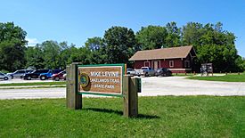
A sign along the trail in Pinckney
|
|
| Location | Lower Peninsula, Ingham County, Livingston County, Washtenaw County, Michigan USA |
| Nearest city | Pinckney, Michigan |
| Governing body |
Michigan Department of Natural Resources
|
| Length | 26 mi (42 km) |
| Trailheads | Stockbridge, Michigan Hamburg Township, Michigan |
| Use | Cycling, Horseback riding, Hiking, XC skiing |
| Difficulty | Easy |
| Season | All |
| Website | Official site: http://www.dnr.state.mi.us/parksandtrails/Details.aspx?id=465&type=SPRK |
The Lakelands Trail State Park, also known as the Mike Levine Lakelands Trail State Park since 2017, is a special state park in Michigan. It's a long trail that goes from east to west. You can find it stretching from Stockbridge all the way to Hamburg Township, Michigan.
This trail was once an old railroad line that was no longer used. Now, it's a "multi-use" trail, which means lots of different activities can happen on it! It's about 26 miles (42 km) long. The Michigan Department of Natural Resources (DNR) says that one side of the trail is for walking and biking. The other side is for people who want to ride horses.
Parts of the trail, especially from Munith to west of Pinckney, have different surfaces. Some sections are made of crushed limestone, others have slag and sand, or are simply unpaved. However, about 10 miles (16 km) of the trail in Hamburg Township are paved.
What Can You Do on the Trail?
The Lakelands Trail is perfect for many outdoor activities.
- Hiking and Walking: You can enjoy a nice walk or a long hike on the trail.
- Biking: Cyclists love the paved sections, especially the 10 miles (16 km) part in Hamburg Township. This paved area is great for a smooth ride.
- Horseback Riding: If you love horses, you can ride them on the unpaved parts of the trail. This is very popular from Stockbridge to Pinckney.
- Cross-Country Skiing: When winter comes and there's snow, the trail becomes a fun place for cross-country skiing.
Where Does the Trail Go?
The Lakelands Trail connects several towns and areas. It's easy to find places to start your adventure. Here are some key spots along the trail:
| Location | What's There? | Distance from last spot (approx.) |
Coordinates |
|---|---|---|---|
| Stockbridge, Michigan | Parking | 42°26′43″N 84°10′47″W / 42.44541°N 84.17966°W | |
| Gregory, Michigan | Parking | ↑ 5 miles (8.0 km) | 42°27′37″N 84°05′05″W / 42.46027°N 84.08474°W |
| Pinckney, Michigan | Parking | ↑ 7.3 miles (11.7 km) | 42°27′38″N 83°56′33″W / 42.46056°N 83.94238°W |
| Merrill Road | Parking | ↑ 6.2 miles (10.0 km) | 42°27′14″N 83°49′16″W / 42.45388°N 83.82121°W |
| Hamburg Road | ↑ 1 mile (1.6 km) | 42°26′52″N 83°48′06″W / 42.44773°N 83.80168°W |
 | John T. Biggers |
 | Thomas Blackshear |
 | Mark Bradford |
 | Beverly Buchanan |


