Congress Lands West of Miami River facts for kids
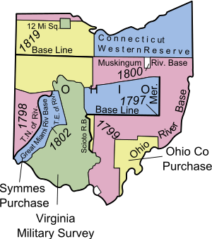
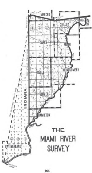
The Congress Lands West of Miami River was a large area of land in southwest Ohio. The United States Congress created this land tract in the late 1700s. It is located south of the Greenville Treaty Line, east of what is now Indiana, and north of the Great Miami River. When it was first surveyed in 1798, it included a small triangular piece of land that is now part of Indiana.
Contents
How Did the Land Become Available?
In 1787, before this land was set aside, the Continental Congress sold land east of the Great Miami River. This area was known as the Symmes Purchase. It was sold to Judge John Cleves Symmes from New Jersey.
Later, in 1795, a very important agreement called the Treaty of Greenville was signed. This treaty opened up new lands for settlement. It meant that lands west and north of the Miami River, and south and east of the Greenville Treaty Line, were now available.
What Was the Land Survey Like?
The survey of the Congress Lands West of Miami River began in 1798. The goal was to divide the land into neat, organized squares.
How Were Townships and Sections Measured?
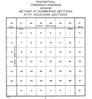
- Land was measured into square areas called "townships". Each township was about six miles (9.656 km) on each side.
- These townships were created using lines running north-south and east-west.
- Townships were placed in rows called "ranges," which ran north-south.
- Each township was then divided into thirty-six smaller squares called "sections".
- Each section was one square mile (2.59 km²) or 640 acres.
- All these ranges, townships, and sections were given numbers in a specific way.
The First Principal Meridian
The First Principal Meridian was a special north-south line. It started where the Great Miami River meets the Ohio River.
- Ranges were numbered going east and west from this main line.
- Townships east of the meridian were numbered from south to north, starting at the Great Miami River.
- Townships west of the meridian were numbered from south to north, starting at the Ohio River.
- This system meant that townships next to each other often had different numbers.
Numbering Sections in a Township
Sections within each township were numbered according to a plan from May 18, 1796. This plan helped people easily find specific plots of land. In 1802, the Ohio Enabling Act set the western border of Ohio along the First Principal Meridian.
How Was the Land Sold?
The Land Act of May 18, 1796, said that land in this area would be sold in Cincinnati. Later, on May 10, 1800, a special Federal Land Office was set up in Cincinnati just for these sales. Land was also sold from the nation's capital through the General Land Office. Over time, the local offices closed. The State of Ohio also sold lands that the federal government had given to them, such as section 16 of each township, which was often used to support schools.
What Was College Township?
In September 1803, Congress decided to set aside 23,321 acres (about 36.4 square miles) of land. This land was in the Congress Lands West of Miami River. It was meant to be used for "an academy, other public schools and seminaries of learning." This land greatly helped Miami University, which was officially started in 1809. The state legislature named the town where the university was built Oxford. This special area, called the College Township, is in township 5 of range 1 east. Today, it is known as Oxford Township, Butler County, Ohio.
Which Counties Are in This Area Today?
Today, the area that was part of the original survey in Ohio includes all or parts of nine counties:
 | Isaac Myers |
 | D. Hamilton Jackson |
 | A. Philip Randolph |


