Symmes Purchase facts for kids
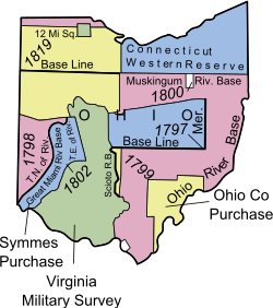
The Symmes Purchase, also called the Miami Purchase, was a large area of land in what is now southwestern Ohio. This land was bought by Judge John Cleves Symmes from New Jersey in 1788. It was purchased from the Continental Congress, which was the government of the United States at that time. The land covered about 311,682 acres, which is like 487 square miles. Today, this area includes parts of Hamilton, Butler, and Warren counties.
Contents
How the Symmes Purchase Began
In the 1780s, a man named Benjamin Stites, who was a friend of Judge Symmes, was exploring the area. He was very impressed by how fertile and rich the land was. When he returned, he told Symmes all about it. Symmes then decided to form a group of people, called the Miami Company, to buy this land.
Buying the Land
The original plan was to buy 1,000,000 acres. However, the Miami Company could not afford such a large amount of land. So, they ended up buying a smaller portion. They paid for and received about 311,686 acres. This land was located in the southwestern part of the larger area they first wanted. The price for the land was very low, only about 66 cents per acre.
Where the Symmes Purchase Was Located
The Symmes Purchase land is bordered by three important rivers. To the south, it is next to the Ohio River. The Great Miami River forms its western border. On the east, the land is bordered by the Little Miami River. The northern edge of the land goes through Butler and Warren counties. This northern border is about 25 miles north of the Ohio River. Some roads today, like Todhunter and Garver Roads in Monroe, follow this old boundary line.
Surveying the Land
When people bought land in this area, their property deeds often mentioned the "Between the Miami Rivers Survey". This survey was also sometimes called "M.Rs." or "M.R.S."
Problems with the Survey
Unfortunately, the people who surveyed the land for Judge Symmes made many mistakes. One big problem was that they used a compass that pointed to magnetic north. They should have adjusted it to point to true north, which is the actual North Pole. This caused errors in the land measurements.
Also, Symmes sold land that he did not actually own. Some of this land was as far north as Dayton. This meant that some early settlers found themselves living on land that belonged to the government. These settlers were called squatters. Symmes even sold some of the land he did own more than once to different people.
Early Settlements in the Area
In 1788, three settlements started to grow in the Symmes Purchase area. All of them were located near the Ohio River. These early towns were called Losantiville, North Bend, and Columbia.
Growth of Cincinnati
Losantiville was later renamed Cincinnati in 1789. This renaming was done by Arthur St. Clair, who was the governor of the Northwest Territory. These settlements were among the very first towns in Ohio and the Northwest Territory. To protect these new communities, a fort was built in 1789. This fort was named Fort Washington.
 | Jewel Prestage |
 | Ella Baker |
 | Fannie Lou Hamer |


