Montgomery County, Ohio facts for kids
Quick facts for kids
Montgomery County
|
|||||
|---|---|---|---|---|---|
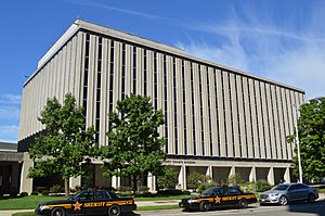
Current Montgomery County Courthouse
|
|||||
|
|||||
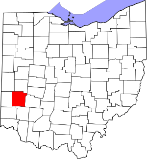
Location within the U.S. state of Ohio
|
|||||
 Ohio's location within the U.S. |
|||||
| Country | |||||
| State | |||||
| Founded | May 1, 1803 | ||||
| Named for | Richard Montgomery | ||||
| Seat | Dayton | ||||
| Largest city | Dayton | ||||
| Area | |||||
| • Total | 464 sq mi (1,200 km2) | ||||
| • Land | 462 sq mi (1,200 km2) | ||||
| • Water | 2.8 sq mi (7 km2) 0.6%% | ||||
| Population
(2020)
|
|||||
| • Total | 537,309 | ||||
| • Estimate
(2021)
|
535,840 |
||||
| • Density | 1,158.0/sq mi (447.1/km2) | ||||
| Time zone | UTC−5 (Eastern) | ||||
| • Summer (DST) | UTC−4 (EDT) | ||||
| Congressional district | 10th | ||||
Montgomery County is a county in the southwestern part of Ohio, a state in the United States. In 2020, about 537,309 people lived here. This makes it the fifth-largest county in Ohio by population.
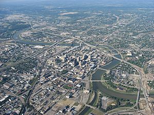
The main city and county seat is Dayton. The county is named after Richard Montgomery. He was an important general during the American Revolutionary War. General Montgomery died in 1775 while trying to capture Quebec City, Canada. Montgomery County is also part of the larger Dayton Metropolitan Statistical Area.
Contents
Geography
Montgomery County covers a total area of about 464 square miles. Most of this area, about 462 square miles, is land. The rest, about 2.8 square miles, is water. This means only a small part (0.6%) of the county is water.
Neighboring Counties
Montgomery County shares its borders with several other counties:
- Miami County (to the north)
- Clark County (to the northeast)
- Greene County (to the east)
- Warren County (to the south)
- Butler County (to the southwest)
- Preble County (to the west)
- Darke County (to the northwest)
Main Roads
Many important highways run through Montgomery County. These roads help people travel easily across the county and to other parts of Ohio.
 Interstate 70
 Interstate 75
 Interstate 675
 U.S. Route 35
 U.S. Route 40
 State Route 4
 State Route 48
 State Route 49
Protected Areas
Part of the Dayton Aviation Heritage National Historical Park is located in Montgomery County. This park helps protect important places related to aviation history.
Population Information
| Historical population | |||
|---|---|---|---|
| Census | Pop. | %± | |
| 1810 | 7,722 | — | |
| 1820 | 15,999 | 107.2% | |
| 1830 | 24,362 | 52.3% | |
| 1840 | 31,938 | 31.1% | |
| 1850 | 38,218 | 19.7% | |
| 1860 | 52,230 | 36.7% | |
| 1870 | 64,006 | 22.5% | |
| 1880 | 78,550 | 22.7% | |
| 1890 | 100,552 | 28.0% | |
| 1900 | 130,146 | 29.4% | |
| 1910 | 163,763 | 25.8% | |
| 1920 | 209,532 | 27.9% | |
| 1930 | 273,481 | 30.5% | |
| 1940 | 295,480 | 8.0% | |
| 1950 | 398,441 | 34.8% | |
| 1960 | 527,080 | 32.3% | |
| 1970 | 606,148 | 15.0% | |
| 1980 | 571,697 | −5.7% | |
| 1990 | 573,809 | 0.4% | |
| 2000 | 559,062 | −2.6% | |
| 2010 | 535,153 | −4.3% | |
| 2020 | 537,309 | 0.4% | |
| 2021 (est.) | 535,840 | 0.1% | |
| U.S. Decennial Census 1790-1960 1900-1990 1990-2000 2010-2020 |
|||
In 2020, Montgomery County had a population of 537,309 people. This means it is a busy and populated area. The county has grown a lot since it was founded. For example, in 1810, only 7,722 people lived there.
Education
Montgomery County has many schools and colleges. These institutions help students learn and grow.
Colleges and Universities
There are several places for higher education in the county:
Public Colleges
- Air Force Institute of Technology (located at Wright-Patterson AFB, Ohio)
- Sinclair Community College
- Wright State University (even though it has a Dayton address, it's mostly in Greene County, Ohio)
Private Colleges
- University of Dayton
- Kettering College of Medical Arts
- The Miami Valley School
Public Schools
Many public school districts serve students in Montgomery County. Here are some of them:
- Local School Districts
- Brookville Local Schools
- Brookville High School (the Blue Devils)
- Carlisle Local School District
- Carlisle High School (the Indians)
- Jefferson Township Local Schools
- Jefferson Township High School (the Broncos)
- New Lebanon Local Schools
- Dixie High School (the Greyhounds)
- Northmont City School District
- Northridge Local School District
- Northridge High School (the Polar Bears)
- Mad River Local Schools
- Walter E. Stebbins High School (the Indians)
- Valley View Local Schools
- Valley View High School (the Spartans)
- Brookville Local Schools
- City School Districts
- Centerville City Schools
- Centerville High School (the Elks)
- Dayton Public Schools
- Dunbar High School (the Wolverines)
- Meadowdale High School (the Lions)
- Stivers School for the Arts (Tigers)
- Huber Heights City Schools
- Wayne High School (the Warriors)
- Kettering City School District
- Fairmont High School (the Firebirds)
- Miamisburg City Schools
- Miamisburg High School (the Vikings)
- Northmont City Schools
- Northmont High School (the Thunderbolts)
- Oakwood City School District
- Oakwood High School (the Lumberjacks)
- Trotwood-Madison City Schools
- Trotwood-Madison High School (the Rams)
- Vandalia Butler City Schools
- Butler High School (the Aviators)
- West Carrollton Schools
- West Carrollton Senior High School (the Pirates)
- Centerville City Schools
There is also a special public school focused on STEM (Science, Technology, Engineering, and Math):
- The Dayton Regional STEM School
Private Schools
Several private high schools are also in Montgomery County:
- Archbishop Alter High School (the Knights) (Roman Catholic)
- Carroll High School (the Patriots) (Roman Catholic)
- Chaminade Julienne High School (Eagles) (Roman Catholic/Marianist)
- Dayton Christian High School (the Warriors) (nondenominational Christian)
- Dominion Academy (the Sabers) (Christ the King Anglican Church)
- Miami Valley School (the Rams) (nonsectarian)
- Salem Christian Academy
- Spring Valley Academy (Seventh-day Adventist)
Communities
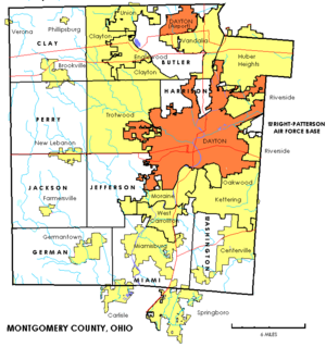
Montgomery County is made up of many different cities, villages, and townships. Each community has its own unique character.
Cities
- Brookville
- Carlisle (mostly in Warren County)
- Centerville (partly in Greene County)
- Clayton
- Dayton (the county seat)
- Englewood
- Germantown
- Huber Heights (partly in Miami County)
- Kettering (partly in Greene County)
- Miamisburg
- Moraine
- Oakwood
- Riverside
- Springboro (mostly in Warren County)
- Trotwood
- Union (mostly in Montgomery County)
- Vandalia
- West Carrollton
Villages
- Farmersville
- New Lebanon
- Phillipsburg
- Verona (mostly in Preble County)
Townships
- Butler
- Clay
- German
- Harrison
- Jackson
- Jefferson
- Miami
- Perry
- Washington
Other Communities
- Drexel (a census-designated place)
- Fort McKinley (a census-designated place)
- Airhill (an unincorporated community)
- Northridge (an unincorporated community)
- Shiloh (an unincorporated community)
Images for kids
See also
 In Spanish: Condado de Montgomery (Ohio) para niños
 | Aurelia Browder |
 | Nannie Helen Burroughs |
 | Michelle Alexander |


