Clayton, Ohio facts for kids
Quick facts for kids
Clayton, Ohio
|
|
|---|---|

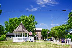
Talmadge Road
|
|
| Motto(s):
"The Learning Community"
|
|

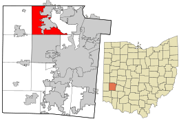
Location in Montgomery County and the state of Ohio.
|
|
| Country | United States |
| State | Ohio |
| Counties | Montgomery |
| Area | |
| • Total | 18.58 sq mi (48.13 km2) |
| • Land | 18.51 sq mi (47.95 km2) |
| • Water | 0.07 sq mi (0.18 km2) |
| Elevation | 955 ft (291 m) |
| Population
(2020)
|
|
| • Total | 13,310 |
| • Estimate
(2023)
|
13,222 |
| • Density | 718.99/sq mi (277.60/km2) |
| Time zone | UTC-5 (Eastern (EST)) |
| • Summer (DST) | UTC-4 (EDT) |
| ZIP Code |
45315
|
| Area code(s) | 937, 326 |
| FIPS code | 39-15644 |
| GNIS feature ID | 2397639 |
| Website | http://www.clayton.oh.us/ |
Clayton is a city in Montgomery County, Ohio, United States. It is a suburb of Dayton and part of the larger Dayton metropolitan area. In 2020, about 13,310 people lived in Clayton. The city got its name from John Clayton, who was a soldier in the War of 1812.
Contents
Where is Clayton Located?
Clayton covers about 18.6 square miles (48.1 square kilometers). Most of this area is land, with a small part being water. In 1998, Clayton grew bigger by joining with the rest of Randolph Township.
A Look at Clayton's History
Clayton was first planned out in 1816 and was known as Salem back then. It faced some challenges when a major road, the National Road, was built around it instead of through it. In 1906, it became a stop on the Dayton Northern Traction Line, which was a type of electric railway. Clayton officially became a city in 1998 when it merged with the rest of Randolph Township, Montgomery County, Ohio.
Who Lives in Clayton?
Population Changes Over Time
The number of people living in Clayton has changed quite a bit over the years. Here's a quick look at how the population has grown:
| Historical population | |||
|---|---|---|---|
| Census | Pop. | %± | |
| 1950 | 466 | — | |
| 1960 | 550 | 18.0% | |
| 1970 | 773 | 40.5% | |
| 1980 | 752 | −2.7% | |
| 1990 | 713 | −5.2% | |
| 2000 | 13,347 | 1,771.9% | |
| 2010 | 13,209 | −1.0% | |
| 2020 | 13,310 | 0.8% | |
| 2023 (est.) | 13,222 | 0.1% | |
| Sources: | |||
A Snapshot of Clayton's People (2010)
In 2010, there were 13,209 people living in Clayton. These people lived in 5,118 households, with 3,766 of those being families. The city had about 713 people per square mile.
Most people in Clayton were White (76.5%), and a good number were African American (18.8%). There were also smaller groups of Native American, Asian, and people of two or more races. About 1.4% of the population was Hispanic or Latino.
The average age of people in Clayton was 42.6 years old.
- 23.4% of residents were under 18.
- 7.6% were between 18 and 24.
- 22.3% were between 25 and 44.
- 32.7% were between 45 and 64.
- 14% were 65 or older.
The city had a nearly even split between males (49.0%) and females (51.0%).
Schools in Clayton
Clayton is part of the Northmont City School District. This district runs several schools that serve the community:
- Northmont High School
- Northmont Middle School
- Englewood Elementary
- Englewood Hills Elementary
- Northmoor Elementary
- Northwood Elementary
- Union Elementary
- Kleptz Early Learning Center
Famous People from Clayton
Some notable people have connections to Clayton:
- Jesse "Pop" Haines – A famous baseball player who is in the Baseball Hall of Fame.
- Chris Hero – A professional wrestler who was a tag team champion in Ring of Honor.
- Johnnie Wilder, Jr. – The lead singer of the popular funk band Heatwave.
Clayton in Stories
Part of the well-known novel The Fountainhead by Ayn Rand is set in Clayton.
See also
 In Spanish: Clayton (Ohio) para niños
 | Georgia Louise Harris Brown |
 | Julian Abele |
 | Norma Merrick Sklarek |
 | William Sidney Pittman |

