West Carrollton, Ohio facts for kids
Quick facts for kids
West Carrollton, Ohio
|
|||
|---|---|---|---|

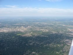
Aerial view of West Carrollton/ Miamisburg
|
|||
|
|||

Location in Montgomery County and the state of Ohio.
|
|||
| Country | United States | ||
| State | Ohio | ||
| County | Montgomery | ||
| Area | |||
| • Total | 6.65 sq mi (17.23 km2) | ||
| • Land | 6.43 sq mi (16.65 km2) | ||
| • Water | 0.22 sq mi (0.58 km2) | ||
| Elevation | 715 ft (218 m) | ||
| Population
(2020)
|
|||
| • Total | 13,129 | ||
| • Density | 2,042.47/sq mi (788.55/km2) | ||
| Time zone | UTC-5 (Eastern (EST)) | ||
| • Summer (DST) | UTC-4 (EDT) | ||
| ZIP code |
45449
|
||
| Area code(s) | 937, 326 | ||
| FIPS code | 39-83111 | ||
| GNIS feature ID | 1065462 | ||
| Website | www.westcarrollton.org | ||
West Carrollton is a city in Montgomery County, Ohio, United States. It's like a smaller town right next to the bigger city of Dayton, Ohio. In 2020, about 13,129 people lived there. The city is part of the larger Dayton area. The Great Miami River flows through West Carrollton and makes up most of its northern edge.
Contents
Exploring West Carrollton's Location
West Carrollton covers about 6.66 square miles (17.23 square kilometers). Most of this area is land, with a small part being water. This includes the Great Miami River that runs through the city.
How Many People Live Here?
| Historical population | |||
|---|---|---|---|
| Census | Pop. | %± | |
| 1850 | 226 | — | |
| 1870 | 350 | — | |
| 1890 | 360 | — | |
| 1900 | 987 | 174.2% | |
| 1910 | 1,285 | 30.2% | |
| 1920 | 1,430 | 11.3% | |
| 1930 | 2,101 | 46.9% | |
| 1940 | 2,176 | 3.6% | |
| 1950 | 2,876 | 32.2% | |
| 1960 | 4,749 | 65.1% | |
| 1970 | 10,748 | 126.3% | |
| 1980 | 13,148 | 22.3% | |
| 1990 | 14,403 | 9.5% | |
| 2000 | 13,818 | −4.1% | |
| 2010 | 13,143 | −4.9% | |
| 2020 | 13,129 | −0.1% | |
| 2021 (est.) | 13,012 | −1.0% | |
| Sources: | |||
A Look at the 2010 Population
In 2010, there were 13,143 people living in West Carrollton. These people lived in 5,973 homes. The city had about 2,041 people per square mile.
Most people living in West Carrollton were White (86.8%). About 8.9% were African American, and smaller groups included Asian and Native American people. About 2.6% of the population was Hispanic or Latino.
Many homes (27.3%) had children under 18 living there. About 37.4% of homes were married couples. Some homes were led by a single parent, either a mother (13.4%) or a father (5.7%). About 35.1% of all homes had just one person living in them.
The average age of people in West Carrollton was 37.5 years old. About 21.1% of residents were under 18, and 14.5% were 65 or older. The city had slightly more females (51.8%) than males (48.2%).
A Brief History of West Carrollton
West Carrollton was first named Carrollton when it was founded in 1830. The name was changed to West Carrollton to avoid confusion with another town in Ohio also called Carrollton.
In the past, West Carrollton had a symbol that looked like a simple five-sided shape (a pentagon). This shape represented the city's strong history with transportation. At one point, five different ways to travel passed through the town: trains, canals, riverboats, trolleys, and cars.
Learning in West Carrollton
Public schools in West Carrollton are managed by the West Carrollton City School District. This school district also serves the nearby city of Moraine, Ohio.
West Carrollton High School is the only high school in the district. Its sports teams are called the "Pirates," and their school colors are scarlet and black. In the 2013–14 school year, about 900 students attended the high school. The district also has four elementary schools and one early childhood center for younger students. The Ohio Department of Education has rated West Carrollton schools as "Effective" since 2002, which means they are doing a good job.
West Carrollton also has a public library. It's a branch of the Dayton Metro Library, where kids and adults can borrow books and use other resources.
See also
 In Spanish: West Carrollton (Ohio) para niños
 | Jessica Watkins |
 | Robert Henry Lawrence Jr. |
 | Mae Jemison |
 | Sian Proctor |
 | Guion Bluford |


