Congress Lands East of Scioto River facts for kids
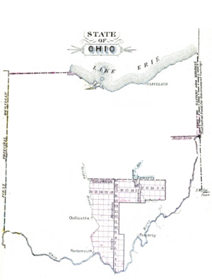
The Congress Lands East of Scioto River was a large area of land in southern Ohio. The United States government created this land tract in the late 1700s. It was located south of the United States Military District and the Refugee Tract. To its west was the Virginia Military District, and to its east were the Seven Ranges. The Ohio River, French Grant, and the Ohio Company of Associates were to its south.
Contents
How the Land Was Claimed and Measured
From French Control to American Land
Before the United States existed, this land was part of the Ohio Country. Great Britain took control of it from France after the Treaty of Paris in 1763. However, the British government then made a rule, the Royal Proclamation of 1763, that stopped white settlers from moving into this area.
After the American Revolutionary War ended in 1783 with another Treaty of Paris, the United States claimed this region. The new American government, under the Articles of Confederation, needed a way to organize and sell this land. They also needed money!
The Land Ordinance of 1785
To solve this, Congress passed the Land Ordinance of 1785. This law created a formal way to survey, sell, and settle the land. It was a very important step in how America grew.
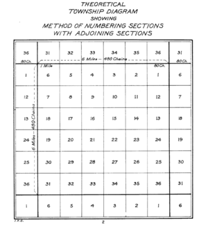
The plan was to divide the land into perfect squares called "townships." Each township was six miles (about 9.6 kilometers) on each side. These townships were arranged in rows called "ranges." Each township was then divided into 36 smaller squares called "sections." Each section was one square mile (about 2.59 square kilometers) or 640 acres. These ranges, townships, and sections were all numbered in a specific way.
Starting the Survey Lines
The first north-south line for surveying was called the Eastern Ohio Meridian. This line was also the western border of Pennsylvania. People sometimes called it Ellicott’s Line after Andrew Ellicott, who helped survey it.
The first east-west line was called the Geographer’s Line or Base Line. It started where the Pennsylvania border met the north bank of the Ohio River. This spot is known as the Beginning Point of the U.S. Public Land Survey40°38′33″N 80°31′10″W / 40.64250°N 80.51944°W. The Geographer’s Line was supposed to go west across all the land between the Ohio River and Lake Erie.
Early Land Divisions in Ohio
There was a small problem: Connecticut claimed some land north of the 41st parallel. So, in 1786, Congress told Thomas Hutchins, the Geographer of the United States, to only survey south of the Geographer's Line. His team finished surveying seven ranges by 1787. This area became known as the Seven Ranges.
Around this time, other land tracts were also created in Ohio:
- In 1784, Virginia received land west of the Scioto River for its American Revolutionary War veterans. This was called the Virginia Military District.
- The Ohio Company of Associates bought land next to the Seven Ranges in 1787. They started settling and surveying there in 1788.
- In 1795, Congress gave land near the Ohio River to French immigrants who had been cheated. This became the French Grant.
- On June 1, 1796, Congress created the United States Military District. This area was west of the Seven Ranges, east of the Scioto River, and south of the Greenville Treaty Line.
Surveying the Congress Lands
After all these other surveys, there was still a large area of land in southern Ohio, east of the Scioto River, that hadn't been surveyed. This was the area that became the Congress Lands East of Scioto River.
Surveying for these lands began in 1799, following a law from 1796. The ranges and townships here continued the numbering system from the original Seven Ranges. Ranges were numbered westward from Pennsylvania. Townships within each range were numbered from south to north, starting at the Ohio River (called the Ohio River Base). Some townships in ranges 22 and 23 started numbering from the Scioto River. This meant that townships in nearby ranges could have different numbers. Sections were numbered according to the 1796 pattern.
Sometimes, there were small mistakes or differences in the numbering due to surveying errors or multiple surveys.
The Refugee Tract
Starting in 1801, a strip of land about 103,527 acres (419 square kilometers) along the northern edge of the Congress Lands was given by Congress to refugees from Canada. This area became known as the Refugee Tract.
Selling the Land
At first, the law said that lands in this survey area should be sold in Pittsburgh. But later, new laws changed things.
- The Land Act of May 10, 1800, created a Land Office in Chillicothe. This office sold lands in the 16th range and areas to the west.
- Another land district was set up in Marietta. This office sold lands in the 15th range and areas to the east.
- In 1803, a new land district was created in Zanesville for lands in the 15th range and eastward.
Sales were also handled from the nation's capital at the General Land Office. Eventually, many of the local offices closed. The State of Ohio also sold lands that the federal government had given to them. This included section 16 of each township, which was often set aside for schools, and the Salt Reservations.
The Congress Lands Today
Today, the area covered by the Congress Lands survey in Ohio is huge. It includes more than 3.5 million acres (14,164 square kilometers). This land covers all or parts of many counties in Ohio, including: Fairfield, Franklin, Gallia, Guernsey, Hocking, Jackson, Lawrence, Morgan, Muskingum, Noble, Perry, Pickaway, Pike, Ross, Scioto, Vinton, and Washington.
 | Shirley Ann Jackson |
 | Garett Morgan |
 | J. Ernest Wilkins Jr. |
 | Elijah McCoy |


