Royal Proclamation of 1763 facts for kids
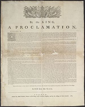
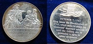
The Royal Proclamation of 1763 was a special announcement made by King George III of Great Britain. It was issued on October 7, 1763. This happened right after the Treaty of Paris (1763), which officially ended the Seven Years' War. That treaty gave French lands in North America to Great Britain.
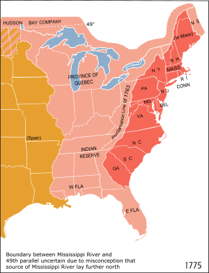
The Proclamation said that no one could settle west of a line drawn along the Appalachian Mountains. This area was set aside as an Indian Reserve for Native American peoples. This rule made many colonists and land investors upset. The Proclamation and the issue of western lands became a big disagreement between Britain and the colonies. It was one of the reasons that led to the American Revolution.
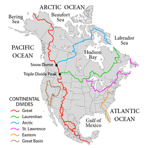
The 1763 proclamation line generally followed the Eastern Continental Divide. This line stretched from Georgia in the south up to New England.
Today, the Royal Proclamation is still very important for First Nations in Canada. It was the first time the law recognized aboriginal title, which means the original rights of Indigenous peoples to their lands. It also recognized their rights and freedoms. This recognition is now part of the Constitution Act, 1982 in Canada.
Contents
What Was the Treaty of Paris?
The Seven Years' War was a big global conflict. Its North American part was called the French and Indian War. This war ended with the Treaty of Paris in 1763.
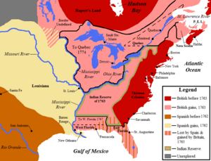
Under this treaty, France gave up a lot of its land in North America. All French lands west of the Mississippi River went to Spain. All French lands east of the Mississippi River went to Great Britain. However, France kept two small islands called Saint Pierre and Miquelon. Both Spain and Britain also gained some French islands in the Caribbean.
New Rules and New Colonies
The Proclamation of 1763 helped manage the new lands Britain got from France. It also aimed to control how colonists expanded their settlements. The Proclamation created new governments for several areas. These included the province of Quebec and the new colonies of West Florida and East Florida. It also included a group of Caribbean islands like Grenada and Dominica. These islands were called the British Ceded Islands.
The Proclamation Line
The Royal Proclamation of 1763 set clear limits for British territories in North America. It stopped British colonists from expanding too far into the continent.
The part of New France east of the Great Lakes and the Ottawa River became "Quebec." The land northeast of the St. John River in Labrador was given to the Newfoundland Colony.
The lands west of Quebec and west of the Allegheny Mountains became (British) Indian Territory. Colonists from the east were not allowed to settle there.
Why Was the Line Created?
The proclamation line was not meant to be a forever border. It was a temporary line that could be moved west later in an organized way. People could cross the line, but they could not settle past it.
The line followed the mountains where rivers began. All land with rivers flowing into the Atlantic Ocean was for the colonies. All land with rivers flowing into the Mississippi River was for Native American groups.
The Proclamation also made it illegal for private individuals to buy land directly from Native Americans. This had caused many problems before. From then on, all land purchases had to be made by Crown officials. These purchases would happen at public meetings with the Native Americans. British colonists were not allowed to settle on Native lands. Colonial officials could not give out land without the King's approval.
How Colonists Reacted
British colonists and land investors did not like the proclamation line. The British government had already given land grants to some of them. For example, wealthy owners of the Ohio Company wanted to settle land to grow their businesses. Many settlements already existed beyond the line. Some had even been temporarily left during Pontiac's War. Also, many land claims had been granted but not yet settled. George Washington, for instance, had been granted lands past the boundary for his service in the French and Indian War.
Important American colonists and land investors in Britain pushed the government to move the line further west.
Changes to the Line
The colonists' requests were heard. The boundary line was changed through several treaties with Native Americans.
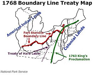
Two important treaties happened in 1768:
- The Treaty of Fort Stanwix changed the border with the Iroquois Confederacy in the Ohio Country.
- The Treaty of Hard Labour changed the border with the Cherokee in the Carolinas.
The Treaty of Hard Labour was followed by the Treaty of Lochaber in 1770. This treaty adjusted the border between Virginia and the Cherokee. These agreements opened up much of what is now Kentucky and West Virginia for British settlement.
Lasting Impact
For Indigenous Peoples
The Royal Proclamation continued to guide how Indigenous land was given up in British North America. This was especially true in Upper Canada and Rupert's Land. Upper Canada created a system for making treaties based on the Proclamation.
Historians have different ideas about whether the Proclamation helped or hurt the independence of Native American tribes. Some see it as a very important document for First Nations land claims and self-government. They say it was the first time the British Crown legally recognized Aboriginal rights. It also placed a special duty of care on the Crown towards Indigenous peoples.
However, some argue that the promises made to Native Americans were only temporary. They were meant to calm Native peoples who were angry about settlers taking their lands. A British official named Sir William Johnson wrote in 1764 that:
The Indians all know we cannot be a Match for them in the midst of an extensive woody Country ... from whence I infer that if we are determined to possess Our Posts, Trade & ca securely, it cannot be done for a Century by any other means than that of purchasing the favour of the numerous Indian inhabitants.
Anishinaabe legal expert John Borrows has said that the Proclamation shows Britain trying to control First Nations. But it also tried to promise First Nations that they would stay separate from European settlers. Borrows believes the Proclamation, along with the Treaty of Niagara, supports the idea that Indigenous peoples have the power to decide for themselves, especially regarding their lands.
Johnson v. McIntosh Court Case
The main ideas of the Proclamation were brought into American law by a U.S. Supreme Court decision. This happened in the case of Johnson v. McIntosh in 1823.
250th Anniversary
In October 2013, people celebrated the 250th anniversary of the Royal Proclamation. Indigenous leaders and the Governor-General of Canada met in Ottawa. The Aboriginal movement Idle No More also held celebrations for this important document across Canada.
In the United States
Historians have different views on how much the Royal Proclamation of 1763 led to the American Revolution. Many historians say that the Proclamation stopped being a big problem after 1768. This was because later treaties opened up large areas for settlement.
Others argue that colonial anger about the Proclamation helped create a bigger gap between the colonies and Britain. Some historians believe that even though the boundary was moved west, the British government still did not want new colonial settlements. They feared starting another war with Native Americans, which angered land investors.
George Washington received 20,000 acres (81 km2) of land in the Ohio region for his service in the French and Indian War. In 1770, Washington worked to secure the rights for himself and his soldiers. He even traveled to the western region to find and survey land for them. He eventually received official documents for these land areas. These lands were open to Virginians under the Treaty of Lochaber of 1770.
In the United States, the Royal Proclamation of 1763 ended with the American Revolutionary War. This is because Great Britain gave the land to the United States in the Treaty of Paris (1783). After that, the U.S. government also found it hard to stop violence on the frontier. They eventually adopted rules similar to those in the Royal Proclamation.
The first of several Indian Intercourse Acts was passed in 1790. These laws stopped uncontrolled trade and travel in Native American lands. In 1823, the U.S. Supreme Court case Johnson v. McIntosh ruled that only the U.S. government, not private people, could buy land from Native Americans.
See also
 In Spanish: Proclamación real de 1763 para niños
 | James Van Der Zee |
 | Alma Thomas |
 | Ellis Wilson |
 | Margaret Taylor-Burroughs |


