Saint-Jean River (Minganie) facts for kids
Quick facts for kids Saint-Jean River |
|
|---|---|

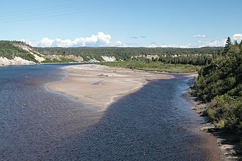
The river viewed from Quebec Route 138
|
|
| Other name(s) | Rivière Saint-Jean |
| Country | Canada |
| Province | Quebec |
| Region | Côte-Nord |
| RCM | Minganie |
| Physical characteristics | |
| River mouth | Gulf of Saint Lawrence 0 metres (0 ft) 50°17′00″N 64°20′04″W / 50.283333°N 64.334444°W |
| Length | 240 kilometres (150 mi) |
| Basin features | |
| Basin size | 5,599 square kilometres (2,162 sq mi) |
| Tributaries |
|
The Saint-Jean River (also called Rivière Saint-Jean in French) is a large river in Quebec, Canada. It flows into the Gulf of Saint Lawrence, which is part of the Atlantic Ocean. This river is special because it's known as one of the best places for salmon fishing on the North Shore of Quebec.
The river flows through the Minganie Regional County Municipality in the Côte-Nord region. The town of Rivière-Saint-Jean is named after this river. You can travel by boat on about 50 kilometres (31 mi) of the river. There are also special fishing camps along its banks.
Contents
Where the River Flows
The Saint-Jean River starts high up, about 500 metres (1,600 ft) above sea level. It begins in the southwest part of Labrador. From there, it travels about 240 kilometres (150 mi) through rough land. Finally, it reaches the Gulf of Saint Lawrence.
The river's end point is about 160 kilometres (99 mi) east of Sept-Îles. At its mouth, the river flows past the village of Rivière-Saint-Jean. It also goes under Quebec Route 138, a main road.
The area drained by the river, called its basin, covers 5,599 square kilometres (2,162 sq mi). This large area is located between the basins of the Magpie River and the Mingan River. It includes parts of Lac-Jérôme and Longue-Pointe-de-Mingan.
River Features
The Saint-Jean River starts from Lake Kaministukuakamaht. This lake is about 612 metres (2,008 ft) above sea level. Many small streams feed into this lake. From the lake, the river flows for about 229.2 kilometres (142.4 mi). It drops 612 metres (2,008 ft) in height along its journey.
Upper River Journey
In its upper part, the Saint-Jean River flows for about 48.7 kilometres (30.3 mi). It starts by flowing northeast, then turns southeast. It passes through a lake and collects water from other lakes. The river also flows near Mount Kapiskuapustent. It picks up water from Coupeaux Lake before meeting the Labône River.
Middle River Journey
After the Labône River, the Saint-Jean River continues for about 63.2 kilometres (39.3 mi). It flows southeast, then south, through a deep valley. It collects water from other streams and forms large curves. It then meets the Rapide River. Further downstream, it collects water from the Utnikan stream. The Poisset River also joins the Saint-Jean River in this section.
The next part of the middle river is about 51.6 kilometres (32.1 mi) long. It flows southeast, then south, through valleys. It picks up water from Lake Élie. Then, it flows southeast until it meets the Saint-Jean North-East River.
From the Saint-Jean North-East River, the Saint-Jean River flows for about 22.3 kilometres (13.9 mi). It generally heads southeast, forming many wide curves. It passes by a small community called Tshiahahtunekamuk. This section ends where the Salmon River joins it.
Lower River Journey
The final part of the Saint-Jean River is about 43.4 kilometres (27.0 mi) long. It flows south through a deep valley. It forms several loops and curves. It collects water from the Méo stream. Further down, it passes by the community of Kaministnahkuteht. It also flows around Little Mantus Island. The Chambers River joins the Saint-Jean River in this area.
Finally, the river flows south, making a large loop around the Kamikuapiskat peninsula. It collects water from Beaver Lake. It then goes under the Quebec Route 138 bridge. It flows past the village of Rivière-Saint-Jean. Here, the Sacré-Coeur River adds its waters. The Saint-Jean River then reaches its mouth at the Gulf of Saint Lawrence. At low tide, the sandy area at the mouth stretches for about two kilometers.
River Name History
The local Indigenous people, the Innu, have their own name for this river. They call it "Usasumekw". This name means "salmon river" in their language. The official name "Rivière Saint-Jean" was made official on December 5, 1968. This was done by the Commission de toponymie du Québec, which names places in Quebec.
Fishing for Salmon
The Saint-Jean River is famous for its salmon. In May 2015, the Quebec government announced new rules for fishing large salmon. For sixteen rivers, including the Saint-Jean, anglers had to catch and then release large salmon. This means they had to put the fish back in the water.
Some groups, like the Quebec Atlantic Salmon Federation, felt these rules were not enough. They believed that to protect salmon for the future, catch-and-release should be used on almost all rivers. This was because the number of Atlantic salmon was decreasing quickly.
A company called Pourvoirie de la Haute Saint-Jean manages fishing on parts of the river. They have special rights to three fishing areas. These areas have 55 fishing spots along 30 kilometres (19 mi) of the Saint-Jean River. They also manage 14 kilometres (8.7 mi) of the Salmon River (Rivière aux Saumons). Between 2012 and 2016, an average of 123 young salmon and 28 large salmon were caught each year. About 412 salmon were released back into the water.
 | Anna J. Cooper |
 | Mary McLeod Bethune |
 | Lillie Mae Bradford |


