Mingan River facts for kids
Quick facts for kids Mingan River |
|
|---|---|

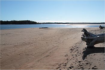
Beach in the river's estuary
|
|
| Native name | Ekuantshiht Hipu or Memekuauhekau Hipu |
| Country | Canada |
| Province | Quebec |
| Region | Côte-Nord |
| RCM | Minganie |
| Physical characteristics | |
| Main source | 579 metres (1,900 ft) |
| River mouth | Gulf of Saint Lawrence 0 metres (0 ft) 50°17′45″N 63°59′22″W / 50.295833°N 63.989444°W |
| Length | 117 kilometres (73 mi) |
| Basin features | |
| Basin size | 2,330 square kilometres (900 sq mi) |
The Mingan River (also called Rivière Mingan in French) is a 117-kilometer-long river in Quebec, Canada. It's famous for its salmon! The river flows from north to south and ends up in the Gulf of Saint Lawrence.
Contents
Where is the Mingan River Located?
The Mingan River starts high up in the Canadian Shield, about 579 meters (1,900 feet) above sea level. It flows for 117 kilometers (73 miles) all the way down to the ocean. Most of the river flows through a rocky valley with lots of fir and spruce trees. Closer to the end, it flows between banks made of sand and marble.
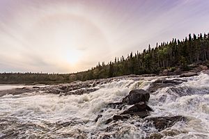
The river's path is mostly straight, but it has two big curves before it reaches its wide mouth. You'll find huge waterfalls about 9 kilometers (5.6 miles) from where it meets the sea. There are also other fast-flowing parts (rapids) further north.
You can travel by boat from the river's mouth up to these rapids. When the river's water level is low, salty ocean water can reach more than 1 kilometer (0.6 miles) upstream. The river flows into the Saint Lawrence River across from Île du Havre de Mingan, an island at the west end of the Mingan Archipelago.
The river's mouth is just east of the Mingan Indian reserve. It's located in the town of Havre-Saint-Pierre in the Minganie Regional County Municipality. This spot is about 12 kilometers (7.5 miles) east of the village of Longue-Pointe-de-Mingan. There's a walking path along the river's east bank, starting from the Quebec Route 138 bridge. It goes for 5 kilometers (3.1 miles) to a nice picnic area.
What Does "Mingan" Mean?
The local Innu people have their own names for the river: Ekuantshiht Hipu or Memekuauhekau Hipu. The name "Mingan" might come from a French word meaning "white stone."
In 1735, a mapmaker named Richard Testu de La Richardière called the bay at the river's mouth "Grande Rade de Meigan." Later, in 1784, the famous explorer James Cook called it "Baye de Mingan." The river itself is shown on a map from 1775 by John Mitchell.
What is the Mingan River Like?
A book from 1914 called Dictionnaire des rivières et lacs de la province de Québec describes the Mingan River as one of the most beautiful in the region. It says you can paddle a light canoe up the river to a large rapid, about 9 miles (14.5 km) from its mouth. After that, rapids make it hard to go further.
The river banks near the sea are clay hills with sand and dark soil. Further inland, the banks become granite rocks. For about 20 miles (32 km) from its mouth, the area mostly has burnt trees and grasslands. The river is excellent for catching salmon and trout.
Local Indigenous people used to visit the river for hunting. They would gather at Mingan when they returned. The Hudson's Bay Company even had a fur trading post there. Mingan harbor is also one of the best on the coast because islands protect it from strong winds. The land near the river is good for farming, and vegetables like potatoes and cabbages grow well.
The Mingan River Basin
The area that drains into the Mingan River is called its basin, and it covers about 2,330 square kilometers (899 square miles). This basin is long and narrow, stretching about 110 kilometers (68 miles) from north to south. It's usually 20 to 30 kilometers (12 to 19 miles) wide, but the northern part is only about 10 kilometers (6 miles) wide.
To the west, the Mingan River basin is next to the Saint-Jean River basin. To the east, it borders the Romaine River basin. Most of the river basin is in an unorganized territory called Lac-Jérôme (71.1%). Smaller parts are in the towns of Havre-Saint-Pierre (16.5%) and Longue-Pointe-de-Mingan (11.6%). A tiny part (0.78%) is in the Mingan reserve.
River Landscape and Geology
Most of the river's watershed is on a high, flat area (plateau) that gently slopes south. This plateau has deep valleys carved by the river. The highest point in the area is 814 meters (2,671 feet) above sea level. The sides of the river valleys can rise 250 to 350 meters (820 to 1,150 feet) above the river. Some cliffs are more than 100 meters (330 feet) high!
The land between the inland plateau and the flat coastal area is about 20 kilometers (12 miles) wide. It has rounded rocky hills that go up to 300 meters (980 feet) high. The coastal plain is flatter and 4 to 12 kilometers (2.5 to 7.5 miles) wide, with some low hills under 150 meters (490 feet) high.
The rocks under the ground are mostly magmatic, which means they formed from melted rock. This includes a large area of anorthosite and some granitoid rocks. On the plateau and hills, the bedrock is covered by a thin layer of glacial till (rock and soil left by glaciers), usually less than 1 meter (3 feet) deep. You can often see the bare rock on slopes and hilltops.
The main valleys contain sediments left by glaciers and rivers (glaciofluvial sediments), and some long, winding ridges called eskers. The coastal plain has a lot of clay and silt. These were left by the Goldthwait Sea after the glaciers melted. Later, sandier sediments from deltas and estuaries covered these fine layers.
Water Flow and Features
The smaller streams and rivers follow cracks in the hard bedrock, often flowing in straight lines that meet at right angles. In the high plateau, the rivers usually flow straight through old V-shaped valleys formed by glaciers. The larger rivers in the middle of the basin have more winding paths through U-shaped glacial valleys.
In its final section, the Mingan River flows straight through loose coastal sediments. Then, it makes two big curves before entering the Saint Lawrence River. The river has a wide mouth (estuary) that is about 1.8 kilometers (1.1 miles) long and 420 meters (1,380 feet) wide on average. This estuary is like a submerged delta with many channels and shallow areas. These are formed by erosion from the river banks downstream.
The average amount of water flowing out of the river each year is about 66 cubic meters per second (2,300 cubic feet per second). This amount changes throughout the year, from 16 to 149 cubic meters per second (570 to 5,260 cubic feet per second). When the water flow is low, salty ocean water can travel up the estuary about 1.5 kilometers (0.9 miles) to the Quebec Route 138 bridge.
The Mingan River gets its water from the Mingan Northwest and Mingan Northeast rivers in the north. Other rivers that flow into it (tributaries) include the Mitshem Kutshieu River, which drains the west-central part of the basin, and the Manitou River, which joins the Mingan about 5 kilometers (3.1 miles) from its mouth. Another tributary on the east bank drains lakes Charles, Jérôme, and Kleczkowski.
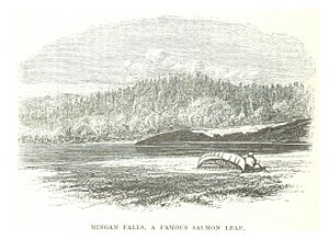
Waterfalls on the Mingan River include the Nakatshuan Mantu Hipis, Kakahtshekaut, Kastjekawt, and Mingan Falls. The Mingan Falls are 9 kilometers (5.6 miles) from the river's mouth. Water quality tests in the 1980s showed the water was a bit acidic but generally good. The main issue was how cloudy it could be.
Lakes and Wetlands
Several lakes are connected to the Mingan River system. Lakes André and Charles in the north cover about 5.93 square kilometers (2.29 square miles). Lake Kleczkowski in the northwest covers 9.16 square kilometers (3.54 square miles). Lake Cugnet in the south-central area covers 3.8 square kilometers (1.5 square miles). The connected lakes Manitou, Gros Diable, and Petit Diable in the south cover a large area of 29.2 square kilometers (11.3 square miles). Lake Patterson in the south covers 3.39 square kilometers (1.31 square miles).
In total, lakes and other water bodies cover about 8.73% of the entire river basin. Wetlands, like bogs and marshes, cover 1.81% of the basin. Most of these wetlands are peatlands found on the flat coastal plain. There aren't many wetlands in the higher plateau or hilly areas because there aren't many flat spots for them to form. However, there is a 2-square-kilometer (0.77 square mile) peat bog about 10 kilometers (6.2 miles) north of where the Mingan Northwest River joins the main Mingan River.
Environment and Wildlife
The weather station near the Saint-Jean River, about 23 kilometers (14 miles) from the Mingan River's mouth, reports an average yearly temperature of 1.4 degrees Celsius (34.5 degrees Fahrenheit). The average yearly rainfall is 1094 millimeters (43.1 inches).
The forests around the river are mostly made up of black spruce (Picea mariana) and balsam fir (Abies balsamea). Further north, there are more spruce trees than fir trees. Other trees you might see include white spruce (Picea glauca), jack pine (Pinus banksiana), paper birch (Betula papyrifera), and trembling aspen (Populus tremuloides).
These forests are generally old and untouched, with few fires or logging in recent years. However, in the late 1980s, 1990s, and early 2000s, there was a big outbreak of hemlock looper moths. These moths ate many of the fir tree leaves in the middle of the basin.
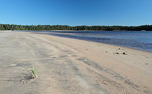
There are three special areas near the south of the watershed that help protect waterfowl (birds that live near water). These are the Mingan West Beach, Mingan River Beach, and Île du Havre de Mingan.
Fish and Fishing

The Innu people have used this land for hunting and fishing for a very long time. Europeans also started fishing for salmon here in the early 1800s. A company called Pourvoirie du Lac Allard et Rivière Mingan manages fishing in part of the river, but they don't have exclusive rights.
The Mingan River is well-known for its Atlantic salmon (Salmo salar). You can also find other fish species here, such as rainbow smelt (Osmerus mordax), brook trout (Salvelinus fontinalis), Atlantic sturgeon (Acipenser oxyrinchus oxyrinchus), northern pike (Esox lucius), lake whitefish (Coregonus clupeaformis), and brown trout (Salmo trutta).
Other fish living in the river include round whitefish (Prosopium cylinraceum), lake trout (Salveninus namaycush), burbot (Lota lota), alewife (Alosa pseudoharengus), American shad (Alosa sapidissima), Atlantic tomcod (Microgadus tomcod), and American eel (Anguilla rostrata).
The number of salmon caught in the river went down in the early 2000s, which meant fewer salmon were living there. In November 2015, a program called the North Shore Atlantic Salmon Habitat Enhancement Program helped. They gave money to the Ekuanitshit Innu Council and the Manitou-Mingan Outfitters. This money was used to help salmon get past the waterfalls more easily to reach their spawning (egg-laying) sites upstream.
The first part of this project involved building a series of 14 connected pools and a channel to control water flow. Once finished, the river above the first falls would be much better for salmon. It would provide 84% of the river basin's potential salmon habitat along 69 kilometers (43 miles) of the river.
 | Emma Amos |
 | Edward Mitchell Bannister |
 | Larry D. Alexander |
 | Ernie Barnes |


