
Mingan facts for kids
Quick facts for kids
Mingan
Ekuanitshit
|
|
|---|---|

Mingan
Location in Côte-Nord region, Quebec
|
|
| Country | Canada |
| Province | Quebec |
| Region | Côte-Nord |
| Regional county | none |
| Formed | 1963 |
| Area | |
| • Total | 38.38 km2 (14.82 sq mi) |
| • Land | 17.24 km2 (6.66 sq mi) |
| Population
(2021)
|
|
| • Total | 552 |
| • Density | 32.0/km2 (83/sq mi) |
| Time zone | UTC-5 (EST) |
| • Summer (DST) | UTC-4 (EDT) |
| Postal Code |
G0G 1V0
|
| Area code(s) | 418 and 581 |
Mingan, also called Ekuanitshit in the Innu-aimun language, is a special area of land for the Innu First Nations people. It's located at the mouth of the Mingan River, on Mingan Bay, along the northern coast of the Gulf of St. Lawrence. This reserve belongs to the Innu band of Ekuanitshit. Geographically, it is found in the Côte-Nord region of Quebec, Canada.
Contents
Geography of Mingan
The Mingan reserve is easy to reach by car using Quebec Route 138. It is about 10 kilometres (6.2 mi) east of the village of Longue-Pointe-de-Mingan. It is also about 36 kilometres (22 mi) west of downtown Havre-Saint-Pierre.
The community has many services for its residents. These include a health centre and a community radio station. There is also a library, a cultural centre, and a community store. The reserve has its own water and sewer system, a fire station, and a police force.
The name "Mingan" first appeared on a map in 1631 as "mican." Many people think it comes from the Innu word maikan, which means "timber wolf." However, this is not certain. Other ideas suggest it might come from the Basque word mingain, meaning "language." It could also be from the Breton term menguen, which means "white stone."
History of Mingan
_LABRADOR-EXP._p516_NASQUAPEE_INDIANS_AT_THE_HUDSON%27S_BAY_COMPANY%27S_POST_AT_MINGAN.jpg)
For a long time, this area was the home of the Innu people. They would travel from their hunting grounds inland to spend their summers on the coast. Mingan was a popular spot for the Innu to gather. They would fish for salmon, hunt whales, have family meetings, and trade goods with each other.
In 1661, European settlers began to arrive in the area. This marked the start of the fur trade, which lasted until the early 1900s. Companies like the North West Company and later the Hudson's Bay Company had trading posts here. The Innu often visited these posts to trade furs. Even then, they mostly stayed in the area only during the summer months.

The traditional way of life for the Innu changed a lot during World War II. Mining and forestry companies started to move into their lands. After the war, new government programs also affected them. These included mandatory education and housing programs. Also, fur prices changed a lot. All these things led the Innu to settle permanently in Mingan.
On April 30, 1963, the government of Quebec gave 7 square miles (18 km2) of land to the Canadian government. This land was set aside to create a reserve for the Innu people of the Mingan region. However, this first reserve did not include access to the Mingan River. The Innu people relied on this river for their food and way of life. After many years of effort, the river banks were finally added to the reserve in 1983. The reserve was made even larger in 1996.
Population and Language
As of 2022, the Innu band of Ekuanitshit had 690 members. About 635 of these people live in the Mingan community.
In 2021, there were 160 homes occupied by people living on the reserve. The main languages spoken there are:
- English: 0%
- French: 1.8%
- Innu (Montagnais): 82.7%
- French and another language: 16.4%
| Historical census populations – Mingan | |||||||||||||||||||||||||||||||||||||
|---|---|---|---|---|---|---|---|---|---|---|---|---|---|---|---|---|---|---|---|---|---|---|---|---|---|---|---|---|---|---|---|---|---|---|---|---|---|
|
|
||||||||||||||||||||||||||||||||||||
| Source: Statistics Canada | |||||||||||||||||||||||||||||||||||||
Culture and Art

St. George's Church is a Catholic Innu Mission church in Mingan. It was built between 1917 and 1918 by John Maloney. What makes this church special is that it is fully decorated with art created by Innu and Montagnais artists from Ekuanitshit. These artworks show the rich culture and traditions of the Innu people.
- Cultural heritage: Ekuanitshit/St Georges de Mingan church
-
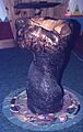
Holy water font or perhaps baptismal font
-
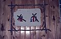
Stations of the cross, stations VI - VII - VIII - IX
-
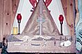
High altar, tabernacle, lamps and painted cloth


Education in Mingan
There is one school on the Mingan reserve called École Teueikan. This school offers classes from pre-Kindergarten up to Secondary grade 4. In the 2008–2009 school year, 106 students were enrolled there.
