
Romaine River facts for kids
The Romaine River is a long river in the Côte-Nord area of Quebec, Canada. It flows for about 496 kilometers (308 miles) and empties into the Gulf of Saint Lawrence. Sometimes, people used to confuse it with the Olomane River, which is further east, because they shared a similar name for a long time.
Quick facts for kids Romaine River |
|
|---|---|
 |
|
| Other name(s) | Rivière Romaine |
| Country | Canada |
| Province | Quebec |
| Region | Côte-Nord |
| Physical characteristics | |
| Main source | Unnamed wilderness 685 m (2,247 ft) 52°52′20″N 63°36′55″W / 52.87222°N 63.61528°W |
| River mouth | Gulf of Saint Lawrence About 15 km west of Havre-Saint-Pierre 0 m (0 ft) 50°18′08″N 63°48′12″W / 50.30222°N 63.80333°W |
| Length | 496 km (308 mi) |
| Basin features | |
| Basin size | 14,350 km2 (5,540 sq mi) |
| Tributaries |
|
Contents
Where is the Romaine River Located?
The Romaine River is about 518 kilometers (322 miles) long. Its eastern bank actually forms part of the border between Quebec and Labrador. This means no part of the river is completely inside Labrador.
The river starts where the waters divide between the Atlantic Ocean and the Saint Lawrence River areas. It first flows through several lakes, like Long Lake and Brûlé Lake. This part of the river helps mark the border between Quebec and Labrador. After that, it mostly flows south until it gets close to the coast. There, it makes a sharp turn west and goes through some small, swampy lakes. Finally, the Romaine River flows into the Jacques Cartier Strait, which is across from the Mingan Archipelago in the Gulf of Saint Lawrence.
What Does the Name Romaine Mean?
The name Romaine has been used since the late 1800s. It comes from an old Native American word, Ouraman or Ulaman. In 1685, a mapmaker named Jean-Baptiste-Louis Franquelin wrote it down. Later, in 1744, Jacques-Nicolas Bellin called it Ramane on his map.
The word comes from unaman, which means "vermilion" or "red ochre". Red ochre is a type of natural clay that has a reddish color. You can find deposits of this red material along the banks of the Olomane River.
The Romaine River Basin
A river basin is the entire area of land where water drains into a specific river. The Romaine River basin covers a large area of about 14,510 square kilometers (5,602 square miles).
This basin is located between the basins of the Mingan River to the west and the Ours River to the east. About 15.5% of the Romaine River basin is in Labrador, north of the provincial border. In Quebec, the basin includes parts of the unorganized area of Lac-Jérôme and the town of Havre-Saint-Pierre.
Inside the river basin, there is a place called Mine du lac Tio. This is a mine where they dig for iron and titanium. The basin also includes an area that might become a special place to protect nature, called the Buttes du Lac aux Sauterelles biodiversity reserve.
Rivers that Flow into the Romaine River
Many smaller rivers and streams flow into the Romaine River. These are called tributaries. Here are some of the important ones, listed from the mouth of the river going upstream:
- Puyjalon River
- Allard River
- South-East Romaine River
- Abbé Huard River
- Garneau River
- West Garneau River
- Little Romaine River
- Touladis River
- Sauterelles River
- Rivière aux Pêchueurs
Fish and Wildlife in the Romaine River
The Romaine River is a home for many types of fish. One important fish found here is the Atlantic salmon. These salmon swim about 52 kilometers (32 miles) upstream to a spot called the Grande Chute.
Other fish species that live in the Romaine River include:
- Brook trout: You can find these fish along the entire length of the river.
- Lake trout: These are found in most of the lakes connected to the river.
- Landlocked salmon: These are Atlantic salmon that live their whole lives in freshwater and do not go out to the ocean. They are found upstream of the Grande Chute.
Images for kids
-
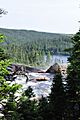
Romaine River near Havre-St-Pierre

See also
 In Spanish: Río Romaine para niños
