
Monroe County, Ohio facts for kids
Quick facts for kids
Monroe County
|
|||
|---|---|---|---|

Monroe County Courthouse
|
|||
|
|||

Location within the U.S. state of Ohio
|
|||
 Ohio's location within the U.S. |
|||
| Country | |||
| State | |||
| Founded | March 1, 1815 | ||
| Named for | James Monroe | ||
| Seat | Woodsfield | ||
| Largest village | Woodsfield | ||
| Area | |||
| • Total | 457 sq mi (1,180 km2) | ||
| • Land | 456 sq mi (1,180 km2) | ||
| • Water | 1.7 sq mi (4 km2) 0.4%% | ||
| Population
(2020)
|
|||
| • Total | 13,385 | ||
| • Estimate
(2021)
|
13,329 |
||
| • Density | 29.29/sq mi (11.308/km2) | ||
| Time zone | UTC−5 (Eastern) | ||
| • Summer (DST) | UTC−4 (EDT) | ||
| Congressional district | 6th | ||


Monroe County is a county located in the eastern part of Ohio. It sits right on the border with West Virginia, with the Ohio River separating them. In 2023, about 13,153 people lived here. This makes it the second-smallest county in Ohio by population.
The main town and county seat is Woodsfield. Monroe County was first created in 1813 and officially started operating in 1815.
Contents
History of Monroe County
Monroe County was formed on January 28, 1813. It was made from parts of Belmont, Guernsey, and Washington counties. The county was named after James Monroe. He was the U.S. Secretary of State when the county was formed. Later, he became the fifth President of the United States.
When the county was first set up, its eastern border was with the state of Virginia. During the American Civil War, this part of Virginia separated. It then became the new state of West Virginia.
Monroe County is mostly rural, meaning it has many farms and open spaces. It had the most people living there in the 1800s. Over time, many people moved to cities for jobs and other chances. Today, it is still home to many Amish families and farms.
In 1891, oil was discovered nearby in West Virginia. This oil field also reached into Monroe County. By 1901, about 300 oil wells near Woodsfield, Ohio were producing a lot of oil. They made 55,000 barrels of oil each month!
Later, around December 20, 2011, a company called ExxonMobil bought rights to drill for natural gas. They bought these rights for over 20,000 acres in Monroe County. This was for gas found in the Utica Shale rock formation.
Geography of Monroe County
Monroe County covers about 457 square miles. Most of this area, 456 square miles, is land. Only a small part, about 1.7 square miles, is water. The Ohio River forms the county's eastern border.
The land here is very hilly. Waterways cut through some of these hills. This area is part of the Appalachian Plateau. This plateau stretches from Lake Erie all the way to the Ohio River.
Counties Nearby
- Belmont County (to the north)
- Marshall County, West Virginia (to the northeast)
- Wetzel County, West Virginia (to the east)
- Tyler County, West Virginia (to the southeast)
- Washington County (to the south)
- Noble County (to the west)
Main Roads in Monroe County
 SR 7
SR 7 SR 26
SR 26 SR 78
SR 78 SR 145
 SR 255
 SR 260
 SR 379
 SR 536
 SR 537
 SR 556
 SR 565
 SR 800
Protected Natural Areas
- Wayne National Forest (a part of it is in Monroe County)
People of Monroe County
| Historical population | |||
|---|---|---|---|
| Census | Pop. | %± | |
| 1820 | 4,645 | — | |
| 1830 | 8,768 | 88.8% | |
| 1840 | 18,521 | 111.2% | |
| 1850 | 28,351 | 53.1% | |
| 1860 | 25,741 | −9.2% | |
| 1870 | 25,779 | 0.1% | |
| 1880 | 26,496 | 2.8% | |
| 1890 | 25,175 | −5.0% | |
| 1900 | 27,031 | 7.4% | |
| 1910 | 24,244 | −10.3% | |
| 1920 | 20,660 | −14.8% | |
| 1930 | 18,426 | −10.8% | |
| 1940 | 18,641 | 1.2% | |
| 1950 | 15,362 | −17.6% | |
| 1960 | 15,268 | −0.6% | |
| 1970 | 15,739 | 3.1% | |
| 1980 | 17,382 | 10.4% | |
| 1990 | 15,497 | −10.8% | |
| 2000 | 15,180 | −2.0% | |
| 2010 | 14,642 | −3.5% | |
| 2020 | 13,385 | −8.6% | |
| 2021 (est.) | 13,329 | −9.0% | |
| U.S. Decennial Census 1790-1960 1900-1990 1990-2000 2010-2020 |
|||
In 2010, there were 14,642 people living in Monroe County. Most people living here were white (98.1%). About 34.8% of people had German family roots. Other common backgrounds included Irish (14.5%) and English (10.6%).
The average age of people in the county was 44.7 years old. The average income for a family was about $43,261 per year.
Education in Monroe County
Monroe County has several schools. They are part of the Switzerland of Ohio Local School District.
Elementary Schools
- Beallsville Elementary School in Beallsville, Ohio
- River Elementary School in Hannibal, Ohio
- Skyvue Elementary School in Graysville, Ohio
- Woodsfield Elementary School in Woodsfield, Ohio
- St. Sylvester Central in Woodsfield, Ohio
High Schools
- Monroe Central High School in Woodsfield, Ohio
- River High School in Hannibal, Ohio
- Beallsville High School in Beallsville, Ohio
Career Center
- Swiss Hills Career Center in Woodsfield, Ohio
Communities in Monroe County
Monroe County has different types of communities.
Villages
- Antioch
- Beallsville
- Clarington
- Graysville
- Jerusalem
- Lewisville
- Miltonsburg
- Stafford
- Wilson
- Woodsfield (This is the county seat)
Townships
- Adams
- Benton
- Bethel
- Center
- Franklin
- Green
- Jackson
- Lee
- Malaga
- Ohio
- Perry
- Salem
- Seneca
- Summit
- Sunsbury
- Switzerland
- Washington
- Wayne
Census-Designated Places
These are areas that are like towns but are not officially incorporated as villages.
Unincorporated Communities
These are smaller communities that are not officially part of a village or township.
Ghost Town
- Quarry (This is a town that no longer has people living in it)
Notable People from Monroe County
- Philip Allen, who was a member of the Wisconsin State Assembly.
- William C. Chynoweth, who was a member of the Illinois House of Representatives.
- Sam V. Stewart, who was a judge on the Montana Supreme Court and the sixth Governor of Montana.
Images for kids
-
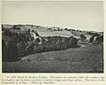
Hill farms in Monroe County, 1923
-
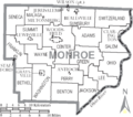
Map of Monroe County, Ohio with municipal and township labels
_(cropped2).jpg)

See also
 In Spanish: Condado de Monroe (Ohio) para niños
