Marshall County, West Virginia facts for kids
Quick facts for kids
Marshall County
|
||
|---|---|---|

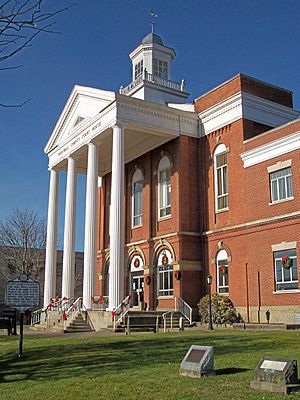
Marshall County Courthouse
|
||
|
||

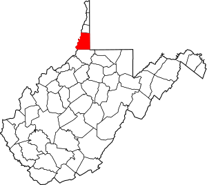
Location within the U.S. state of West Virginia
|
||
 West Virginia's location within the U.S. |
||
| Country | ||
| State | ||
| Founded | March 12, 1835 | |
| Seat | Moundsville | |
| Largest city | Moundsville | |
| Area | ||
| • Total | 312 sq mi (810 km2) | |
| • Land | 305 sq mi (790 km2) | |
| • Water | 6.7 sq mi (17 km2) 2.2%% | |
| Population
(2020)
|
||
| • Total | 30,591 | |
| • Estimate
(2021)
|
30,115 |
|
| • Density | 98.05/sq mi (37.86/km2) | |
| Time zone | UTC−5 (Eastern) | |
| • Summer (DST) | UTC−4 (EDT) | |
| Congressional district | 1st | |
Marshall County is a county located in the state of West Virginia. In 2020, about 30,591 people lived here. The main town and county seat is Moundsville. Marshall County is at the southern end of the Northern Panhandle of West Virginia, right on the Ohio River. It's also part of the larger Wheeling metropolitan area.
This county is famous for the Grave Creek Mound in Moundsville. This is the biggest cone-shaped burial mound in North America! Marshall County was officially created in 1835 from Ohio County. A big moment happened in 1852 when the Baltimore and Ohio Railroad reached the Ohio River in Marshall County. More recently, it became home to the New Vrindaban community and Prabhupada's Palace of Gold, which are popular places to visit.
Contents
History of Marshall County
Ancient Times and Early Settlers
Long ago, around 250 BCE, Native Americans lived along the Ohio River in this area. The Adena culture built the huge Grave Creek Mound by 100 BCE. It was one of the tallest burial mounds in what is now the United States.
By the 1700s, no permanent Native American villages were here. However, tribes like the Delaware, Shawnee, Cherokee, and Seneca used the land for hunting and travel. Two important trails crossed here. One was a major north-south path called the "Great Indian Warpath." The other, an east-west trail, later became the National Road.
Coming of European Settlers
In the mid-1700s, explorers from Europe started looking at the Ohio River Valley. Christopher Gist explored for Virginia investors in 1752. French explorers also claimed the land. The British government tried to stop colonists from settling here after a war in 1763.
But settlers still came. John Wetzel built a fort in 1769. The Zane brothers built cabins in 1770 where Wheeling is today. Joseph, James, and Samuel Tomlinson built a cabin near what became Moundsville around the same time.
Sometimes, there were conflicts between the settlers and Native Americans. In 1774, Native Americans tried to push settlers out. This led to a local conflict called Dunmore's War. Virginia soldiers fought and defeated Native American warriors at the Battle of Point Pleasant.
During the American Revolutionary War, more fighting happened. Many settlers left their homes for safer forts. After the war, in 1784, General George Washington even bought land in this area. Peace with local tribes finally came in 1795.
Growth of Towns and Transportation
The first town in Marshall County was Elizabethtown, founded in 1798. It was named after Joseph Tomlinson's wife. Later, another town, Mound City, was built nearby. These two towns eventually joined and became Moundsville.
In 1811, the U.S. government began building the National Road. This important road connected Cumberland, Maryland to Wheeling and areas further west. It reached Wheeling in 1818, bringing more people and businesses. Taverns and inns opened along the road.
Marshall County was officially created on March 12, 1835. It was named after John Marshall, a very important judge who had just passed away. The county's first courthouse was finished in 1836.
Farming was the main job in Marshall County for many years. But trade grew along the Ohio River and the National Road. Flour mills were some of the first businesses.
A big step for the county was when the Baltimore and Ohio Railroad arrived. On December 24, 1852, the railroad reached Rosbys Rock in Marshall County. This made it much easier to transport goods and people. Later, a bridge was built across the Ohio River, connecting Benwood to Ohio.
The Civil War and Beyond
The American Civil War (1861-1865) caused divisions in Marshall County. Some people supported the Union (the North), and others supported the Confederacy (the South). Many people in western Virginia wanted to stay with the Union. This led to the creation of the new state of West Virginia in 1863. Marshall County became one of the first counties in this new state.
After the war, in 1866, West Virginia decided to build a state prison in Moundsville. The West Virginia Penitentiary was a large, gothic-style building. It was the state's main prison from 1876 until 1995. Today, it's a popular tourist attraction.
The U.S. Army Corps of Engineers also worked on the Ohio River. They built locks and dams to control flooding and make it easier for boats to travel. These projects helped transport heavy materials like coal and iron.
In the late 1800s and early 1900s, new industries came to Marshall County. Factories made brooms, bricks, steel, and glassware. The Fostoria Glass Company in Moundsville made beautiful tableware. Coal mining also became very important.
In 1924, Marshall County made history when Dr. Harriet B. Jones was elected. She was the first woman to serve as a legislator in West Virginia. In 1927, the famous pilot Charles Lindbergh even landed near Moundsville!
In 1968, the New Vrindaban community was started near Limestone. Its followers built Prabhupada's Palace of Gold in 1972. Both are now popular places for visitors and are still active communities.
Geography
Marshall County covers about 312 square miles (808 square kilometers). Most of this is land (305 square miles or 789 square kilometers), with about 6.7 square miles (17 square kilometers) of water.
Main Roads
 US 250
 WV 2
WV 2 WV 86
WV 86 WV 88
WV 88 WV 891
Neighboring Counties
- Ohio County (north)
- Washington County, Pennsylvania (northeast)
- Greene County, Pennsylvania (east)
- Wetzel County (south)
- Monroe County, Ohio (southwest)
- Belmont County, Ohio (northwest)
Protected Areas
- Ohio River Islands National Wildlife Refuge (part of it is in Marshall County)
Population Information
| Historical population | |||
|---|---|---|---|
| Census | Pop. | %± | |
| 1840 | 6,937 | — | |
| 1850 | 10,138 | 46.1% | |
| 1860 | 12,997 | 28.2% | |
| 1870 | 14,941 | 15.0% | |
| 1880 | 18,840 | 26.1% | |
| 1890 | 20,735 | 10.1% | |
| 1900 | 26,444 | 27.5% | |
| 1910 | 32,388 | 22.5% | |
| 1920 | 33,681 | 4.0% | |
| 1930 | 39,831 | 18.3% | |
| 1940 | 40,189 | 0.9% | |
| 1950 | 36,893 | −8.2% | |
| 1960 | 38,041 | 3.1% | |
| 1970 | 37,598 | −1.2% | |
| 1980 | 41,608 | 10.7% | |
| 1990 | 37,356 | −10.2% | |
| 2000 | 35,519 | −4.9% | |
| 2010 | 33,107 | −6.8% | |
| 2020 | 30,591 | −7.6% | |
| 2021 (est.) | 30,115 | −9.0% | |
| U.S. Decennial Census 1790–1960 1900–1990 1990–2000 2010–2020 |
|||
2020 Census Details
In 2020, Marshall County had 30,591 people living in 11,811 households. Most people (94.1%) were White. About 0.9% were African American, and 0.4% were Asian. About 1.2% of the population was Hispanic or Latino. The average age in the county was 46.1 years.
2010 Census Details
In 2010, there were 33,107 people in Marshall County. About 98% of the population was White. The average age was 44.3 years. The median income for a household was about $34,419.
Cities and Towns
- Benwood
- Cameron
- Glen Dale
- McMechen
- Moundsville (the county seat)
- Wheeling (most of this city is in Ohio County)
Other Communities
These are smaller communities that are not officially cities or towns:
- Adaline
- Bannen
- Balls-Andersonville
- Beeler’s Station
- Belton (Denver)
- Big Run
- Board Tree (Georgetown)
- Calis (Seatonville)
- Captina
- Chestnut Hill/Archville/Thompson/Round Bottom
- Clouston
- Cresap (Woco)
- Dallas/West Union
- Ella
- Fairview
- Franklin
- Glen Dale/McMechen Heights
- Glen Easton
- Golden
- Graysville (Hornsbrook)
- Howard
- Kausooth
- Knoxville (Goosetown)
- Limestone (Maysville)
- Loudenville
- Lynn Camp
- Majorsville
- McKeefry/Washington Lands
- Meighen
- Millsboro
- Mount Olivet
- Mozart
- Natrium
- Sherrard
- Pleasant Valley
- Poplar Springs
- Proctor
- Rock Lick
- Rosbys Rock
- Saint Joseph (German Settlement)
- Sand Hill
- Teutonia
- Viola
- Welcome
- Wolf Run
- Wood Hill
- Woodlands
- Woodruff
Magisterial Districts
Current Districts
- District 1
- District 2
- District 3
Past Districts
- Cameron
- Clay
- Franklin
- Liberty
- Meade
- Sand Hill
- Union
- Washington
- Webster
See also
 In Spanish: Condado de Marshall (Virginia Occidental) para niños
 | Frances Mary Albrier |
 | Whitney Young |
 | Muhammad Ali |


