Ohio County, West Virginia facts for kids
Quick facts for kids
Ohio County
|
||
|---|---|---|

|
||
|
||

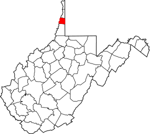
Location within the U.S. state of West Virginia
|
||
 West Virginia's location within the U.S. |
||
| Country | ||
| State | ||
| Founded | October 7, 1776 | |
| Named for | Ohio River | |
| Seat | Wheeling | |
| Largest city | Wheeling | |
| Area | ||
| • Total | 109 sq mi (280 km2) | |
| • Land | 106 sq mi (270 km2) | |
| • Water | 3.2 sq mi (8 km2) 2.9%% | |
| Population
(2020)
|
||
| • Total | 42,425 | |
| • Estimate
(2021)
|
41,776 |
|
| • Density | 389.2/sq mi (150.3/km2) | |
| Time zone | UTC−5 (Eastern) | |
| • Summer (DST) | UTC−4 (EDT) | |
| Congressional district | 1st | |
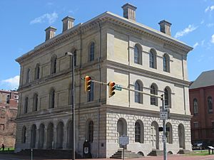
Ohio County is a place in West Virginia, located in the northern part of the state. It's part of the bigger Wheeling area. In 2020, about 42,425 people lived there. Its main town, or county seat, is Wheeling.
Ohio County was created in 1776 from a part of Virginia. It was named after the Ohio River, which forms its western border with the state of Ohio. The town of West Liberty was the first county seat from 1777 to 1797.
Contents
Exploring Ohio County's Geography
Ohio County covers about 109 square miles. Most of this is land (106 square miles), and a small part is water (3.2 square miles). It is the third-smallest county in West Virginia. The highest point in Ohio County is about 1,420 feet high. This spot is located southwest of West Alexander, Pennsylvania.
The county has many small streams and creeks, including Wheeling Creek. When Ohio County was first formed in 1776, it was much larger. Over time, its size changed due to border agreements.
In the past, Ohio County was divided into ten smaller areas called magisterial districts. These were created to help with local government. Later, these districts were combined into five, and then into three larger districts: District 1, District 2, and District 3.
Main Roads in Ohio County
These are the major highways that run through Ohio County:
 I‑70
I‑70 I‑470
I‑470 US 40
US 40 US 250
 WV 2
WV 2 WV 88
WV 88
Neighboring Counties
Ohio County shares its borders with these other counties:
- Brooke County (north)
- Washington County, Pennsylvania (east)
- Marshall County (south)
- Belmont County, Ohio (west)
- Jefferson County, Ohio (northwest)
Ohio County is special because it's one of only four counties in the United States that borders a state with the same name.
Protected Natural Areas
Part of the Ohio River Islands National Wildlife Refuge is located in Ohio County. This refuge helps protect wildlife and their homes along the Ohio River.
People and Population
| Historical population | |||
|---|---|---|---|
| Census | Pop. | %± | |
| 1790 | 5,212 | — | |
| 1800 | 4,740 | −9.1% | |
| 1810 | 9,182 | 93.7% | |
| 1820 | 9,182 | 0.0% | |
| 1830 | 15,584 | 69.7% | |
| 1840 | 13,357 | −14.3% | |
| 1850 | 18,006 | 34.8% | |
| 1860 | 22,422 | 24.5% | |
| 1870 | 28,831 | 28.6% | |
| 1880 | 37,457 | 29.9% | |
| 1890 | 41,557 | 10.9% | |
| 1900 | 48,024 | 15.6% | |
| 1910 | 57,572 | 19.9% | |
| 1920 | 62,892 | 9.2% | |
| 1930 | 72,077 | 14.6% | |
| 1940 | 73,115 | 1.4% | |
| 1950 | 71,672 | −2.0% | |
| 1960 | 68,437 | −4.5% | |
| 1970 | 64,197 | −6.2% | |
| 1980 | 61,389 | −4.4% | |
| 1990 | 50,871 | −17.1% | |
| 2000 | 47,427 | −6.8% | |
| 2010 | 44,443 | −6.3% | |
| 2020 | 42,425 | −4.5% | |
| 2021 (est.) | 41,776 | −6.0% | |
| U.S. Decennial Census 1790–1960 1900–1990 1990–2000 2010–2020 |
|||
In 2010, there were 44,443 people living in Ohio County. There were about 18,914 households, which are groups of people living together. The population density was about 420 people per square mile.
Most people in the county were white (93.2%). Other groups included Black or African American (3.7%) and Asian (0.8%). About 0.8% of the population was of Hispanic or Latino origin. Many people had German, Irish, or English backgrounds.
The average age in Ohio County was 43.5 years. The average income for a household was $39,669. About 15.9% of the population lived below the poverty line. This included 25.2% of people under 18 years old.
Education in Ohio County
Ohio County has many schools and colleges.
Colleges and Universities
- West Liberty University
- Wheeling University
- West Virginia Northern Community College
Public Schools
Ohio County Schools manages all the public schools. High schools teach grades 9-12, middle schools teach grades 6-8, and elementary schools teach grades K-5.
The Ohio County Board of Education oversees these schools. It has five elected members. The current members are Molly J. Aderholt, Christine N. Carder, David Croft, Sarah C. Koegler, and President Zachary T. Abraham. Dr. Kimmberly Miller is the Superintendent.
- Wheeling Park High School
- Bridge Street Middle School
- Triadelphia Middle School
- Warwood Middle School
- Wheeling Middle School
- Bethlehem Elementary School
- Elm Grove Elementary School
- Madison Elementary School
- Middle Creek Elementary School
- Ritchie Elementary School
- Steenrod Elementary School
- Warwood Grade School
- Woodsdale Elementary School
Private and Religious Schools
The Diocese of Wheeling-Charleston runs several schools in Ohio County. These include K-8 schools and one high school.
- Wheeling Central Catholic High School
- Corpus Christi Parish School
- Our Lady of Peace School (also serves Ohio County students)
- St. Michael Parish School
- St. Vincent de Paul Parish School
There are also two other private schools in the county:
- Linsly School
- Wheeling Country Day School
Communities in Ohio County
City
- Wheeling (This is the county seat and is partly in Marshall County.)
Towns
Villages
Magisterial Districts
- District 1
- District 2
- District 3
Unincorporated Communities
These are smaller communities that are not officially cities, towns, or villages:
- Betty Zane
- Clinton
- Eden
- Elm Grove
- Greggsville
- Mount Echo
- Mozart
- Point Mills
- Potomac
- Roneys Point
- Shannon
- Twilight
- Valley Camp
- Warwood
- Whitfield
Fun Things to Do
The Ohio County Fair is held every year in October at Oglebay Park. It's a great place for families to visit.
Gaming and Entertainment
In 2007, a law was passed that allowed counties with racetracks to vote on having table games like blackjack and poker. Ohio County was the first to vote on this. The people of Ohio County voted yes, with 66% in favor. This allowed the Wheeling Island Racetrack and Gaming Center to offer table games.
Famous People from Ohio County
- George W. Atkinson – He was the Governor of West Virginia from 1897 to 1901.
- Nathan B. Scott – He served as a U.S. Senator from 1899 to 1911.
- Walter L. Fisher – He was the United States Secretary of the Interior from 1911 to 1913.
See also
 In Spanish: Condado de Ohio (Virginia Occidental) para niños
 | Anna J. Cooper |
 | Mary McLeod Bethune |
 | Lillie Mae Bradford |


