Wheeling Creek (West Virginia) facts for kids
Wheeling Creek is a river that flows into the Ohio River. It's about 25 miles (40 km) long. This creek is mostly in West Virginia, but its water also comes from parts of Pennsylvania. Its water eventually joins the Mississippi River through the Ohio River. The area that drains into Wheeling Creek is about 300 square miles (780 km²). This area is part of the Allegheny Plateau, a high, flat land. The creek ends its journey in downtown Wheeling, where it flows into the Ohio River. Sometimes, people call it 'Big Wheeling Creek'.
Quick facts for kids Wheeling Creek |
|
|---|---|

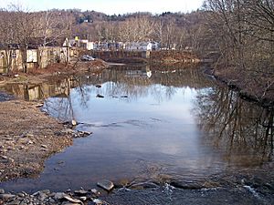
Wheeling Creek in Wheeling in 2006
|
|

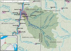
A map of Wheeling Creek and its watershed
|
|
| Country | United States |
| State | West Virginia |
| Counties | Marshall, Ohio |
| Physical characteristics | |
| Main source | Enlow Fork boundary of Greene and Washington Counties, Pennsylvania 1,339 ft (408 m) 40°00′08″N 80°20′27″W / 40.00222°N 80.34083°W |
| 2nd source | Dunkard Fork Confluence of North Fork and South Fork, Richhill Township, Greene County, Pennsylvania 927 ft (283 m) 39°53′33″N 80°28′41″W / 39.89250°N 80.47806°W |
| River mouth | Ohio River Wheeling, West Virginia 630 ft (190 m) 40°03′50″N 80°43′30″W / 40.06389°N 80.72500°W |
| Length | 25 mi (40 km) |
| Basin features | |
| Basin size | 300 sq mi (780 km2)approx. |
Contents
Where Wheeling Creek Begins and Flows
Wheeling Creek starts in northeastern Marshall County, West Virginia. It is formed when two smaller streams, the Enlow Fork and the Dunkard Fork, join together.
The Enlow Fork Stream
The Enlow Fork begins in Pennsylvania, right on the border of Greene and Washington Counties. It flows generally southwest. This stream helps form the northern border of some townships in Greene County and the southern border of townships in Washington County.
The Dunkard Fork Stream
The Dunkard Fork also starts in Pennsylvania. It is created when its North Fork and South Fork streams meet in Richhill Township, Greene County. The North Fork flows through Ryerson Station State Park, where a dam creates a lake.
Wheeling Creek's Journey
After the Enlow and Dunkard forks meet, Wheeling Creek flows northwest. It eventually reaches the city of Wheeling in Ohio County.
In the Elm Grove area of Wheeling, another stream called Little Wheeling Creek joins it. Little Wheeling Creek starts near the Pennsylvania border and flows southwest. It passes through towns like Valley Grove and Triadelphia. In Triadelphia, Little Wheeling Creek picks up Middle Wheeling Creek, which comes from Pennsylvania.
Roads and Trails Along the Creek
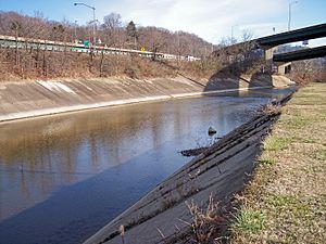
The National Road (U.S. Route 40) runs alongside Little Wheeling Creek in eastern Ohio County. It also follows Wheeling Creek for part of its path through the city of Wheeling. There's also a special trail for walking and biking, called a rail trail, that follows Wheeling Creek for about five miles (8 km) in Wheeling. This trail is part of the Wheeling Heritage Trail network.
Land Around the Creek
The West Virginia Department of Environmental Protection studies the land around Wheeling Creek. They found that about 67% of the land in West Virginia that drains into the creek is covered by forests. About 27% of the land is used for agriculture, like growing crops. The remaining 5% is urban, meaning it has cities and towns.
How Much Water Flows in Wheeling Creek?
The United States Geological Survey has a special station in Elm Grove, Wheeling, that measures how much water flows in the creek. This station is about 7.8 miles (12.6 km) before the creek meets the Ohio River.
Between 1941 and 2005, the average amount of water flowing in the creek was 343 cubic feet per second (9.7 m³/s). To give you an idea, one cubic foot is about the size of a basketball.
The most water ever recorded flowing in the creek was about 22,300 cubic feet per second (632 m³/s) on September 17, 2004. The least amount of water recorded was only 0.1 cubic feet per second (0 m³/s). This happened on October 7, 1963, and on two days in September 1964.
Fishing in Wheeling Creek
Wheeling Creek is a popular spot for fishing, especially for people who live nearby. There are many places along the Wheeling Heritage Trail System where you can easily get to the creek to fish.
You can find many different kinds of fish in Wheeling Creek. Some of the fish species include muskellunge, smallmouth bass, sunfish, hognose suckers, and various types of catfish and bluegill. The creek is also regularly stocked with rainbow trout and brown trout, which means these fish are added to the creek so there are more for people to catch.
 | Frances Mary Albrier |
 | Whitney Young |
 | Muhammad Ali |


