Northern panhandle of West Virginia facts for kids
Quick facts for kids
Northern panhandle
|
|
|---|---|

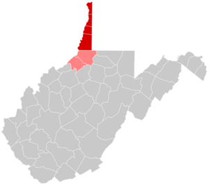
Map of counties in the northern panhandle. Red denotes counties physically part of the region, while light red denotes counties considered to belong to the region culturally, but not physically.
|
|
| Country | United States |
| State | West Virginia |
| Largest city | Wheeling |
| Other cities |
List
|
| Population
(2020 Census)
|
|
| • Total | 147,425 (All counties) 124,670 (Excluding Tyler and Wetzel Counties) |
| Time zone | UTC−5 (EST) |
| • Summer (DST) | UTC−4 (EDT) |
The Northern Panhandle is a unique part of West Virginia. It's shaped like a narrow strip of land, almost like the handle of a pan! This area is special because of its history and culture. It borders Ohio and the Ohio River to the north and west. To the east, it touches the state of Pennsylvania.
In 2013, the two northernmost counties of this area became part of the larger Pittsburgh metropolitan area. This means they are closely connected to the big city of Pittsburgh.
Contents
Where is the Northern Panhandle?
This region includes several counties in West Virginia. They are listed here from north to south:
Many people in West Virginia also think of Wetzel County and sometimes Tyler County as part of the Northern Panhandle. These counties are just south of Marshall County. Even though they aren't strictly in the narrow "handle" part, they share many cultural ties.
How the Panhandle Got Its Shape
The unusual shape of the Northern Panhandle comes from old arguments. Back when the United States was new, the state of Virginia (which West Virginia was once part of) had claims that went along the Ohio River. But the Colony of Pennsylvania had its own ideas about where its border should be. They finally agreed on a compromise in the 1780s. This agreement created the panhandle's unique shape.
Who Lives in the Panhandle?
In 2010, the counties physically in the panhandle had about 132,295 people. If you include Wetzel and Tyler counties, the total was about 158,086 people.
By 2020, the population had changed. The physical panhandle counties had about 124,670 people. Including Wetzel and Tyler counties, the total was about 147,425. This shows a small drop in population. This trend is similar to other areas in the "Rust Belt". The Rust Belt is a term for parts of the northeastern and midwestern U.S. where many factories and industries used to be, but have since declined.
The northern parts of the panhandle are close to the Weirton–Steubenville metropolitan area. They are also part of the larger Pittsburgh Metropolitan Area. The southern counties are part of the Wheeling metropolitan area.
What's the Economy Like?
In the late 1800s, the Northern Panhandle became a busy industrial area. It was especially known for making steel and glass products. Even today, it still has an industrial feel. However, like many places in the Rust Belt, some of its factories have closed or faced tough times. The region also has coal mines.
Banks in these counties are connected to the Federal Reserve Bank of Cleveland. Most other banks in West Virginia are connected to the Federal Reserve Bank of Richmond.
Learning and Colleges
The Northern Panhandle is home to three four-year colleges:
- West Liberty University (a public university)
- Bethany College (a private college)
- Wheeling University (a private university)
All five counties mentioned in this article, plus Tyler County, are also served by West Virginia Northern Community College. This college helps students get ready for jobs or continue their education.
 | Delilah Pierce |
 | Gordon Parks |
 | Augusta Savage |
 | Charles Ethan Porter |

