Southwest Virginia facts for kids
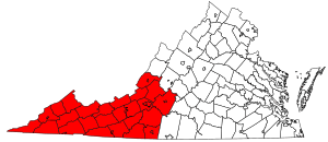
Southwest Virginia, often called SWVA, is a mountainous part of Virginia located in the westernmost area of the state. It's known for its beautiful mountains and unique culture. While Virginia has many different regions, Southwest Virginia feels more like Appalachia because of its geography and history.
This region has always been mostly rural, meaning it has more countryside than big cities. In the past, coal mining was a huge part of its economy. Farmers also grew a lot of tobacco. Today, with fewer coal jobs and less tobacco farming, Southwest Virginia is focusing on tourism. Things like local crafts, music, farm visits (agritourism), and outdoor activities are now important for the economy. People often call this the region's "creative economy."
Many counties are considered part of Southwest Virginia, including: Alleghany, Bland, Botetourt, Buchanan, Carroll, Craig, Dickenson, Floyd, Franklin, Giles, Grayson, Henry, Lee, Montgomery, Patrick, Pulaski, Roanoke, Rockbridge, Russell, Scott, Smyth, Tazewell, Washington, Wise, and Wythe.
Virginia has a special way of defining its cities. Unlike other states, cities in Virginia are "independent," meaning they are not part of any county. Towns, however, are located within counties. Independent cities in Southwest Virginia include: Bristol, Buena Vista, Covington, Galax, Lexington, Martinsville, Norton, Radford, Roanoke, and Salem.
Contents
Culture and Traditions
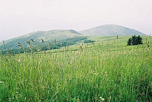
The culture in Southwest Virginia is very similar to the broader Appalachian region. This is mainly because of the area's geography, with the Appalachian Mountains and Blue Ridge Mountains shaping the landscape and how people live. The mountains have historically made this region a bit separate from the rest of Virginia, helping its unique culture grow.
History of Southwest Virginia
Southwest Virginia was one of the last parts of the state to be settled by Europeans. Most of these early settlers were English, German, and Scots-Irish immigrants. They often traveled along a major path called the Great Wagon Road through the Great Appalachian Valley.
Near what is now Roanoke, the wagon road split. One path went towards the Piedmont region, and the other, known as the Wilderness Road, continued southwest into Tennessee and Kentucky. Many forts were built around the time of Lord Dunmore's War to protect the settlers. Some of these forts later became the main towns for new counties.
Early Industries and Growth
The first big industry in Southwest Virginia was salt production. In a town called Saltville, salt was (and still is) taken from the ground by using water to dissolve it. This industry was so important that it helped the town of Abingdon grow.
As more people moved into the region, many of the current counties were created by dividing larger ones. Southwest Virginia also saw parts of its original territory break away to form new states, like Kentucky and West Virginia. During the American Revolution, people from Southwest Virginia fought in the Battle of King's Mountain in South Carolina.
Civil War and Economic Changes
During the Civil War, Southwest Virginia was divided. Some people supported the Union, while others supported the Confederacy. There was a lot of guerilla warfare, which is a type of fighting where small groups use surprise attacks. The main battles in the area were the Battle of Saltville and of Marion in Smyth County.
In 1864, Union General George Stoneman led a raid into Southwest Virginia. He destroyed the important saltworks in Saltville and burned anything else that could help the Confederates.
In the late 1800s and early 1900s, industries that took resources from the earth became very important. These included cutting down timber (trees) and coal mining. However, in recent years, the coal industry has shrunk, leading to fewer jobs and a smaller population in coalfield areas. This has also caused some local issues, like the need to combine schools.
Manufacturing, which was strong for a while in the 20th century, has also declined. Even tobacco farming has decreased. Since the early 2000s, getting natural gas from the ground has become a growing industry, especially in the coalfield region. Across Southwest Virginia, tourism is also becoming a major way to create jobs and help the economy.
Geography of the Region
The Appalachian Mountains greatly influence the geography of Southwest Virginia. These mountains are often seen as separating the region from the rest of Virginia. Southwest Virginia includes parts of the ridge and valley and the Blue Ridge sections of the mountain range.
Within these mountains, coal fields have been a source of economic growth. The main river in the region is the New River, which is believed to be the oldest river in North America.
Flooding has been a big problem in the mountainous areas, with major floods happening often and causing a lot of damage. To prevent future issues, towns like Grundy have taken steps like the Grundy Flood Control and Redevelopment Project. This project moved an entire town up away from the riverbank and onto a new site carved out of a mountainside.
Cities and Towns in Southwest Virginia
Independent Cities in Southwest Virginia:
Towns in Southwest Virginia:
- Appalachia
- Big Stone Gap
- Blacksburg
- Bland
- Bluefield
- Boones Mill
- Buchanan
- Cedar Bluff
- Chilhowie
- Christiansburg
- Claypool Hill
- Clifton Forge
- Clinchport
- Clintwood
- Coeburn
- Damascus
- Dublin
- Duffield
- Dungannon
- Fincastle
- Floyd
- Gate City
- Glade Spring
- Glen Lyn
- Grundy
- Haysi
- Hillsville
- Honaker
- Hurley
- Independence
- Jonesville
- Lebanon
- Marion
- Narrows
- New Castle
- Nickelsville
- Oakwood
- Pearisburg
- Pembroke
- Pennington Gap
- Pound
- Pulaski
- Raven
- Rich Creek
- Richlands
- Rocky Mount
- Rose Hill
- Rural Retreat
- Saltville
- St. Charles
- St. Paul
- Stuart
- Tazewell
- Vansant
- Vinton
- Wise
- Wytheville
Education and Learning
Southwest Virginia has many colleges and universities. The biggest is Virginia Polytechnic Institute and State University, or "Virginia Tech," located in Blacksburg. Virginia Tech is the largest research university in the state and the biggest employer in Montgomery County.
Emory and Henry College is a respected private college near Abingdon. It's known for its focus on community service. In 2014, the Emory and Henry College School of Health Sciences opened in Marion.
There are also medical schools in Blacksburg, and efforts are being made to open another in Abingdon. Law and pharmacy schools have also been developed in Buchanan County, which is in the coalfield region. The region is also working to make higher education easier to access for high school graduates, especially through partnerships between community colleges and other schools.
Colleges and Universities in Southwest Virginia
- Appalachian College of Pharmacy
- Appalachian School of Law
- Bluefield University
- Emory and Henry College
- Ferrum College
- Hollins University
- Jefferson College of Health Sciences
- Mountain Empire Community College
- New River Community College
- Patrick & Henry Community College
- Radford University
- Roanoke College
- Southwest Virginia Community College
- Southern Virginia University
- University of Virginia's College at Wise
- Virginia College of Osteopathic Medicine
- Virginia Highlands Community College
- Virginia-Maryland Regional College of Veterinary Medicine
- Virginia Military Institute
- Virginia Polytechnic Institute and State University
- Virginia Tech Carilion School of Medicine and Research Institute
- Virginia Western Community College
- Washington and Lee University
- Wytheville Community College
Appalachian Regional Commission
The Appalachian Regional Commission (ARC) was created in 1965. Its goal is to help the Appalachian region grow economically, as it was falling behind the rest of the country. The ARC currently includes 420 counties in 13 states, including many in western Virginia.
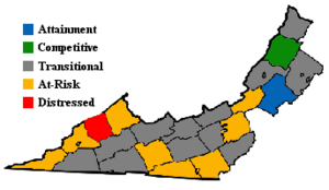
The Commission gives each county one of five economic labels: distressed, at-risk, transitional, competitive, or attainment. "Distressed" counties are the most economically challenged, while "attainment" counties are the most successful. These labels are based on things like unemployment rates, income per person, and poverty rates. For data, independent cities are grouped with a nearby county.
In 2003, Appalachian Virginia (which includes most of Southwest Virginia) had higher unemployment and poverty rates, and lower incomes, compared to the rest of Virginia and the nation. For example, Dickenson County was labeled "Distressed," meaning it faced the most economic challenges. Other counties like Buchanan and Wise were "at-risk." Only Botetourt County was labeled "attainment," showing it was doing very well economically. Most counties in Appalachian Virginia were "transitional," meaning they were doing okay but still lagged behind the national average in some areas.
 | James Van Der Zee |
 | Alma Thomas |
 | Ellis Wilson |
 | Margaret Taylor-Burroughs |


