Henry County, Virginia facts for kids
Quick facts for kids
Henry County
|
|||||
|---|---|---|---|---|---|
|
|||||
|
|||||
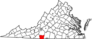
Location within the U.S. state of Virginia
|
|||||
 Virginia's location within the U.S. |
|||||
| Country | |||||
| State | |||||
| Founded | 1777 | ||||
| Named for | Patrick Henry | ||||
| Seat | Martinsville | ||||
| Largest town | Ridgeway | ||||
| Area | |||||
| • Total | 384 sq mi (990 km2) | ||||
| • Land | 382 sq mi (990 km2) | ||||
| • Water | 2 sq mi (5 km2) 0.5% | ||||
| Population
(2020)
|
|||||
| • Total | 50,948 | ||||
| • Density | 132.68/sq mi (51.23/km2) | ||||
| Time zone | UTC−5 (Eastern) | ||||
| • Summer (DST) | UTC−4 (EDT) | ||||
| Congressional district | 9th | ||||
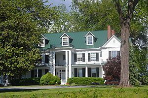
Henry County is a county located in the state of Virginia, USA. In 2020, about 50,948 people lived there.
Martinsville is often called the county seat. A county seat is like the main town where the county government is located. However, many important county offices, like where meetings happen, are actually in Collinsville.
Henry County is part of the Martinsville Micropolitan Statistical Area. This means it's connected to Martinsville for things like jobs and businesses.
Contents
Henry County's History
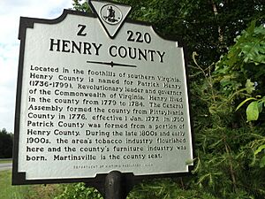
Henry County was created in 1777. It was formed from a part of Pittsylvania County. The new county was first named Patrick Henry County. This was to honor Patrick Henry, who was the first Governor of Virginia. Some of his family lived in the area.
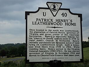
Governor Patrick Henry also owned a large farm called "Leatherwood plantation" in the county. He lived there for five years between his terms as governor.
In 1785, the northern part of Patrick Henry County joined with part of Bedford County to form Franklin County. Then, in 1790, Patrick Henry County was split again. The western part became Patrick County, and the rest remained Henry County.
Important Early Settlers
Many important people settled in Henry County early on. These included Colonel George Waller, Captain George Hairston, and Major John Redd. They were all present when General Cornwallis surrendered at Yorktown during the American Revolutionary War.
Another key figure was Colonel Abram Penn. He led his Henry County militia (a group of citizen soldiers) during the Revolutionary War. He planned to join General Nathanael Greene at the Battle of Guilford Courthouse.
Brigadier General Joseph Martin was also a famous early settler. The city of Martinsville is named after him.
Other notable people included Mordecai Hord, who lived on his farm called Hordsville. Colonel John Dillard was wounded in the Battle of Princeton during the Revolution. He later served on the Committee of Safety. Captain Robert Hairston was a politician and the county's first high sheriff.
Henry County in Wars
During the War of 1812, a group of soldiers called the 64th Virginia Militia was formed in Henry County in 1815.
Later, during the American Civil War, volunteers from Henry County joined the 42nd Virginia Infantry. After the war, Christopher Y. Thomas, who owned Patrick Henry's old Leatherwood plantation, served in the U.S. House of Representatives.
In 1902, the Henry County Historical Society was started in Martinsville. This group helps to preserve the county's history.
Geography of Henry County
Henry County covers about 384 square miles. Most of this area, about 382 square miles, is land. Only about 2 square miles is water.
Henry County is part of the Appalachian Regional Commission. This commission helps with economic development in the Appalachian region.
County Districts
Henry County is divided into six districts. These districts help organize local government and services. They are:
- Axton
- Bassett
- Collinsville
- Horsepasture
- Reed Creek
- Ridgeway
Neighboring Areas
Henry County shares borders with several other counties and one city:
- Franklin County, Virginia - to the north
- Pittsylvania County, Virginia - to the east
- Rockingham County, North Carolina - to the south
- Stokes County, North Carolina - to the southwest
- Patrick County, Virginia - to the west
- Martinsville - this city is completely surrounded by Henry County
Main Roads and Highways
Several important roads run through Henry County, making it easy to travel to and from the area:
 I-73 (future highway)
 US 58
US 58 US 220
 SR 57
SR 57 SR 87
SR 87 SR 108
 SR 174
 SR 457
Population and People
| Historical population | |||
|---|---|---|---|
| Census | Pop. | %± | |
| 1790 | 8,479 | — | |
| 1800 | 5,259 | −38.0% | |
| 1810 | 5,611 | 6.7% | |
| 1820 | 5,624 | 0.2% | |
| 1830 | 7,100 | 26.2% | |
| 1840 | 7,335 | 3.3% | |
| 1850 | 8,872 | 21.0% | |
| 1860 | 12,105 | 36.4% | |
| 1870 | 12,303 | 1.6% | |
| 1880 | 16,009 | 30.1% | |
| 1890 | 18,208 | 13.7% | |
| 1900 | 19,265 | 5.8% | |
| 1910 | 18,459 | −4.2% | |
| 1920 | 20,238 | 9.6% | |
| 1930 | 20,088 | −0.7% | |
| 1940 | 26,481 | 31.8% | |
| 1950 | 31,219 | 17.9% | |
| 1960 | 40,335 | 29.2% | |
| 1970 | 50,901 | 26.2% | |
| 1980 | 57,654 | 13.3% | |
| 1990 | 56,942 | −1.2% | |
| 2000 | 57,930 | 1.7% | |
| 2010 | 54,151 | −6.5% | |
| 2020 | 50,948 | −5.9% | |
| U.S. Decennial Census 1790-1960 1900-1990 1990-2000 2010 2020 |
|||
The population of Henry County has changed over many years. The table above shows how the number of people living in the county has grown and changed since 1790.
2020 Census Information
The 2020 census collected information about the people living in Henry County. This table shows the different racial and ethnic groups.
| Race / Ethnicity (NH = Non-Hispanic) | Pop 2010 | Pop 2020 | % 2010 | % 2020 |
|---|---|---|---|---|
| White alone (NH) | 38,737 | 34,307 | 71.54% | 67.34% |
| Black or African American alone (NH) | 11,786 | 11,062 | 21.77% | 21.71% |
| Native American or Alaska Native alone (NH) | 78 | 68 | 0.14% | 0.13% |
| Asian alone (NH) | 236 | 284 | 0.44% | 0.56% |
| Pacific Islander alone (NH) | 2 | 6 | 0.00% | 0.01% |
| Some Other Race alone (NH) | 43 | 153 | 0.08% | 0.30% |
| Mixed Race or Multi-Racial (NH) | 724 | 1,767 | 1.34% | 3.47% |
| Hispanic or Latino (any race) | 2,545 | 3,301 | 4.70% | 6.48% |
| Total | 54,151 | 50,948 | 100.00% | 100.00% |
Communities in Henry County
Martinsville is an independent city. This means it is not officially part of Henry County, even though the county surrounds it.
Towns
Census-Designated Places (CDPs)
CDPs are areas that are like towns but are not officially incorporated as cities or towns.
- Bassett
- Chatmoss
- Collinsville
- Fieldale
- Horsepasture
- Laurel Park
- Oak Level
- Sandy Level
- Stanleytown
- Villa Heights
Other Unincorporated Communities
These are smaller communities that are not officially part of a town or city.
Notable People from Henry County
Many interesting people have connections to Henry County. Here are a few:
- Ward Armstrong
- Alexander Hunter Bassett
- John D. Bassett
- John Breathitt
- Thomas G. Burch
- H. Clay Earles
- Patrick Henry
- Jeff Hensley
- Jimmy Hensley
- J. C. Martin
- Joseph Martin (general)
- Otis Martin
- Barry Michaels
- Shawn Moore
- Abram Penn
- A. L. Philpott
- Carr Waller Pritchett Sr.
- Robert Hairston
- Rodney Sawyers
- Jessamine Shumate
- Thomas B. Stanley
- John H. Traylor
- Christopher Thomas
- Anne Spencer
See also
 In Spanish: Condado de Henry (Virginia) para niños
 | John T. Biggers |
 | Thomas Blackshear |
 | Mark Bradford |
 | Beverly Buchanan |


