
Henrico County, Virginia facts for kids
Quick facts for kids
Henrico County
|
|||
|---|---|---|---|

The Old Henrico County Courthouse in Richmond.
|
|||
|
|||

Location within the U.S. state of Virginia
|
|||
 Virginia's location within the U.S. |
|||
| Country | |||
| State | |||
| Founded | 1611 | ||
| Named for | the settlement of Henricus | ||
| Seat | Laurel | ||
| Largest city | Tuckahoe | ||
| Area | |||
| • Total | 245 sq mi (630 km2) | ||
| • Land | 237.65 sq mi (615.5 km2) | ||
| • Water | 7.35 sq mi (19.0 km2) 3 (approx)% | ||
| Population
(2020)
|
|||
| • Total | 334,389 | ||
| • Density | 1,364.9/sq mi (527.0/km2) | ||
| Time zone | UTC−5 (Eastern) | ||
| • Summer (DST) | UTC−4 (EDT) | ||
| Congressional districts | 4th, 1st | ||


Henrico County is a county in Virginia, United States. It's often called the County of Henrico. In 2020, about 334,389 people lived here. This makes it the fifth-most populated county in Virginia.
Henrico County is part of the larger Greater Richmond Region. It doesn't have its own official city or town. Instead, a place called Laurel acts as its main center.
The county is named after an old settlement called Henricus. It was first set up as the City of Henrico in 1611. Later, in 1634, it became one of the eight original "Shires" of Virginia. This makes it one of the oldest counties in the United States! The City of Richmond used to be part of Henrico County until 1842, when it became its own independent city.
Today, Henrico County wraps around the City of Richmond. It borders Richmond to the west, north, and east. The Chickahominy River is to the north, and the James River is to the south.
Richmond International Airport is located in the eastern part of Henrico County, near Sandston. Some of the biggest companies that employ people here include Capital One, Bon Secours, and Elevance Health.
Contents
- History of Henrico County
- Transportation in Henrico County
- Geography of Henrico County
- People of Henrico County (Demographics)
- Economy of Henrico County
- Education in Henrico County
- Communities in Henrico County
- Notable People from Henrico County
- Fun Facts About Henrico County
- Images for kids
- See also
History of Henrico County
In 1611, a man named Thomas Dale started a settlement called Henricus. It was on a piece of land in the James River that is now called Farrar's Island. Henricus was named after Henry Frederick, Prince of Wales. Sadly, Native American warriors attacked the English settlers in 1622, and the settlement was destroyed.

In 1634, Henrico Shire became one of the first eight areas (called Shires) in the Virginia Colony. Since then, 10 counties and three independent cities have been created from the original land of Henrico Shire.
Here are some of the places that were formed from Henrico Shire:
| County/City | Year Founded |
|---|---|
| Goochland County | 1728 |
| Albemarle County | 1744 |
| Chesterfield County | 1749 |
| Cumberland County | 1749 |
| Amherst County | 1761 |
| Buckingham County | 1761 |
| Fluvanna County | 1777 |
| Powhatan County | 1777 |
| Nelson County | 1807 |
| City of Richmond | 1842 |
| Appomattox County (part) | 1845 |
| City of Charlottesville | 1888 |
| City of Colonial Heights | 1948 |
In 1776, two men from Henrico, Richard Adams and Nathaniel Wilkenson, helped decide that Virginia should send people to the Continental Congress. This led to the Declaration of Independence.
During the American Revolutionary War, the Henrico militia (local soldiers) helped defend Richmond. In 1781, British forces led by Benedict Arnold and later General Charles Cornwallis occupied Richmond for a short time. However, American and French troops, led by the Marquis de Lafayette, eventually forced Cornwallis to surrender at Yorktown, ending the war.
Since 1842, the City of Richmond has added parts of Henrico County to its own area five times. In 1922, Chesterfield County took over the original site of Henricus.
Henrico was greatly affected by the American Civil War. After the war, during the Reconstruction era, a special educator named Virginia Estelle Randolph (1874-1958) made a big difference. She opened the old Mountain Road School in 1892. In 1908, she became the first "Jeanes Supervisor Industrial Teacher" for Henrico County Schools. She also started the first Arbor Day program in Virginia.
The USS Henrico was a ship that served in World War Two and other conflicts.
In 1961, Richmond tried to completely join with Henrico. But 61% of Henrico voters said no. In 1965, Richmond tried to add 145 square miles of Henrico County. After a long court fight, Richmond was only allowed to take 17 square miles. But because it would have cost Richmond $55 million, they decided not to take the land.
In 1981, Virginia stopped all such land changes across the state. So, Henrico's borders haven't changed since Richmond added land in 1942.
The first main government office (county seat) for Henrico was at Varina. This was at the Varina Farms plantation, across the James River from Henricus. Colonist John Rolfe lived here with his wife, Pocahontas. Henrico's government was at Varina from about 1640 until 1752.
In 1752, Henrico moved its government center to a more central spot in Richmond. It stayed there even after Richmond became its own city in 1842. It wasn't until 1974 that the county moved its offices to a new building in the western part of the county, in Laurel. In 1988, the county opened another government center in the eastern part of the county for easier access.
American Civil War Battle Sites
During the American Civil War, many battles took place in Henrico County in 1862. These were part of the Peninsula Campaign. Some of these battles included:
- Battle of Seven Pines
- Battle of Savage's Station
- Battle of Oak Grove
- Battle of Garnett's & Golding's Farm
- Battle of White Oak Swamp
- Battle of Glendale
- Battle of Malvern Hill
More important battles happened in 1864 during the Overland Campaign. These battles led up to the Siege of Petersburg and the fall of Richmond. Confederate General J.E.B. Stuart was badly wounded in Henrico County at the Battle of Yellow Tavern on May 12, 1864.
Transportation in Henrico County
Henrico County is one of only two counties in Virginia that takes care of its own roads. The other is Arlington County. This is because they had their own road departments before the state agency (now VDOT) was created in 1927. This special status helps the county plan its growth and development.
Richmond International Airport is located in Henrico County. The county also has an Amtrak train station called Richmond Staples Mill Road station. Public bus services are provided by the Greater Richmond Transit Company.
Some old roads are still used today, like Horsepen Road, Three Chopt Road, and Quiocassin Road.
Major Highways
Interstates
US Highways
 US 1
US 1 US 33
US 33 US 60
US 60 US 250
 US 301
 US 360
State Routes
 SR 2
SR 2 SR 5
SR 5 SR 6
SR 6 SR 33
SR 33 SR 73
SR 73 SR 76
SR 76 SR 147
 SR 150
 SR 156
 SR 157
 SR 161
 SR 197
 SR 271
 SR 356
 SR 895
Geography of Henrico County
Henrico County covers about 245 square miles. Most of this is land (234 square miles), and about 11 square miles (4.6%) is water.
Adjacent Counties
Henrico County shares borders with these other counties and cities:
- Charles City County (southeast)
- Chesterfield County (south)
- Goochland County (west)
- Hanover County (north)
- New Kent County (northeast)
- Richmond (south)
- Powhatan County (southwest at James River)
National Protected Area
- Richmond National Battlefield Park (part of it is in Henrico)
Climate
Henrico County has a humid subtropical climate. This means it has hot and humid summers, and winters that are moderately cold. On average, Henrico County gets snow about 8 days a year. The temperature drops below freezing about 88 days a year. It gets hotter than 90 degrees Fahrenheit about 50 days a year, and stays below freezing about 8 days a year.
People of Henrico County (Demographics)
| Historical population | |||
|---|---|---|---|
| Census | Pop. | %± | |
| 1790 | 12,000 | — | |
| 1800 | 14,886 | 24.1% | |
| 1810 | 19,680 | 32.2% | |
| 1820 | 23,667 | 20.3% | |
| 1830 | 28,797 | 21.7% | |
| 1840 | 33,076 | 14.9% | |
| 1850 | 43,572 | 31.7% | |
| 1860 | 61,616 | 41.4% | |
| 1870 | 66,179 | 7.4% | |
| 1880 | 82,703 | 25.0% | |
| 1890 | 103,394 | 25.0% | |
| 1900 | 30,062 | −70.9% | |
| 1910 | 23,437 | −22.0% | |
| 1920 | 18,972 | −19.1% | |
| 1930 | 30,310 | 59.8% | |
| 1940 | 41,960 | 38.4% | |
| 1950 | 57,340 | 36.7% | |
| 1960 | 117,339 | 104.6% | |
| 1970 | 154,364 | 31.6% | |
| 1980 | 180,735 | 17.1% | |
| 1990 | 217,881 | 20.6% | |
| 2000 | 262,300 | 20.4% | |
| 2010 | 306,935 | 17.0% | |
| 2020 | 334,389 | 8.9% | |
| 2023 (est.) | 334,760 | 9.1% | |
| U.S. Decennial Census 1790–1960 1900–1990 1990–2000 2000-2010 2010-2020 |
|||
2020 Census Information
Here's a look at the different groups of people living in Henrico County in 2020:
| Race / Ethnicity (NH = Non-Hispanic) | Pop 2010 | Pop 2020 | % 2010 | % 2020 |
|---|---|---|---|---|
| White alone (NH) | 174,799 | 167,030 | 56.95% | 49.95% |
| Black or African American alone (NH) | 89,449 | 96,332 | 29.14% | 28.81% |
| Native American or Alaska Native alone (NH) | 844 | 888 | 0.27% | 0.27% |
| Asian alone (NH) | 19,956 | 32,175 | 6.50% | 9.62% |
| Pacific Islander alone (NH) | 112 | 127 | 0.04% | 0.04% |
| Some Other Race alone (NH) | 792 | 1,955 | 0.26% | 0.58% |
| Mixed Race or Multi-Racial (NH) | 5,982 | 13,797 | 1.95% | 4.13% |
| Hispanic or Latino (any race) | 15,001 | 22,085 | 4.89% | 6.60% |
| Total | 306,935 | 334,389 | 100.00% | 100.00% |
In 2010, there were 306,935 people living in the county. About 25.1% of the population was under 19 years old. The median age was 38.5 years.
In 2019, the average income for a household in the county was $68,024. The average income for a family was $91,956. About 9% of the people in the county lived below the poverty line.
Economy of Henrico County
Altria Group (which used to be called Philip Morris) has its main office in Henrico County. In 2003, the company moved its headquarters from New York City to Virginia. They estimated this move would save them over $60 million each year. Local economic groups helped bring Altria and other companies like Aditya Birla Minacs, Alfa Laval, Genworth Financial, and Blue Bell Ice Cream to the county.

Top Employers
Here are some of the biggest employers in Henrico County, based on a 2014 report:
| # | Employer | # of employees | Community |
|---|---|---|---|
| 1 | Henrico County Public Schools (Henrico County Government) | 5,000–9,999 | |
| 2 | Capital One | 5,000–9,999 | |
| 3 | Henrico County Government | 1,000–4,999 | Laurel |
| 4 | Henrico Doctors' Hospital | 1,000–4,999 | |
| 5 | Anthem | 1,000–4,999 | |
| 6 | Bank of America | 1,000–4,999 | |
| 7 | Wells Fargo | 1,000–4,999 | Innsbrook |
| 8 | Walmart | 1,000–4,999 | |
| 9 | United States Postal Service (The US Government) | 1,000–4,999 | Sandston |
| 10 | Genworth Financial | 1,000–4,999 | |
| 11 | Kroger | 1,000–4,999 | |
| 12 | SunTrust Banks | 500–999 | |
| 13 | Apex Systems | 500–999 | |
| 14 | Markel | 500–999 | |
| 15 | Virginia Department of Social Services (Commonwealth of Virginia Government) | 500–999 | |
| 16 | Dominion Resources | 500–999 | |
| 17 | Verizon Virginia | 500–999 | |
| 18 | J. Sargeant Reynolds Community College | 500–999 |
Cost of Living
In March 2012, the cost of living in Henrico County was 86.5. This means it was less expensive than the average for the United States, which is 100.
Education in Henrico County
The school division in Henrico County is called Henrico County Public Schools (HCPS). It has 45 elementary schools, 13 middle schools, 10 high schools, and two technical centers.
In 2001, HCPS started giving Apple iBook laptops to every high school student. In 2003, they expanded the program to middle schools. In 2005, the school board decided to switch to Dell laptops for high schoolers. However, in 2006, they decided to keep using Apple iBooks for middle school students. In 2010, HCPS opened two new schools: Holman Middle School and Glen Allen High School.
Communities in Henrico County
There are no official towns or cities within Henrico County. Also, no new towns or cities can be created here. This is because a state law in Virginia stops new towns or cities from forming in counties that have a lot of people living in them (more than 1,000 people per square mile). Henrico was the third county in Virginia to be affected by this law.
Census-Designated Places (CDPs)
These are areas that are like towns but are not officially incorporated as cities or towns.
- Chamberlayne
- Dumbarton
- East Highland Park
- Glen Allen
- Highland Springs
- Innsbrook
- Lakeside
- Laurel
- Montrose
- Sandston
- Short Pump
- Tuckahoe
- Wyndham
Other Communities
Former Towns
Before 1870, the City of Richmond was actually part of Henrico County. But after new state rules in 1870 and 1902, Richmond became its own independent city.
In the late 1800s and early 1900s, several small towns were officially created in Henrico County, usually close to Richmond. These included:
- Barton Heights (became part of Richmond in 1914)
- Fairmount (became part of Richmond in 1914)
- Ginter Park (became part of Richmond)
- Highland Park (became part of Richmond in 1914)
- North Richmond (became part of Richmond)
Notable People from Henrico County
- Van T. Barfoot, a Medal of Honor winner
- Carter Family, a famous folk and country music group
- Georgia May Jobson, a social reformer
- Daniel Lynch IV, a baseball player
- Debbie Matenopoulos, a television personality
- Gabriel Prosser, a Revolutionary
- Schuyler VanValkenburg, a State Senator
- Constance Wu, an actress
Fun Facts About Henrico County
For many years, the United States Postal Service considered most of Henrico County to be part of "unincorporated Richmond." This meant that most places in the county had a Richmond address. However, in 2008, county residents won the right to have "Henrico" as their official mailing address. This change helped the county get back about $5 million in taxes that were mistakenly sent elsewhere. This decision has encouraged other places in Virginia to ask for their own official mailing addresses too.

Henrico County is home to Richmond Raceway. This is a famous racetrack that hosts NASCAR Cup Series races twice a year.
Henrico County is responsible for handling dangerous material spills (HAZMAT) for the entire Central Virginia Region. Because of this, police, fire, and rescue teams across Central Virginia can talk to each other easily during emergencies.
Henrico County has the highest possible financial rating (Triple-A) from three major rating agencies in the United States. This means Henrico is known for being very good at managing its money.
Residents of Henrico County can get mental health and development services from Henrico Area Mental Health and Developmental Services. The fees for these services are based on what people can afford, so no one is turned away because they can't pay.
Lewis Ginter Botanical Garden was started in 1984 and covers about 80 acres. It's one of only two independent public botanical gardens in Virginia and is considered a state botanical garden. It's a public place where people can see and study plants. It has a glass conservatory, a rose garden, a healing garden, and a children's garden that everyone can enjoy.
Images for kids
-
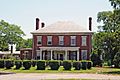
Varina Farms Plantation, where John Rolfe and Pocahontas lived.
-
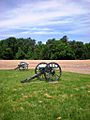
Cannons at the site of the Battle of Malvern Hill.
-
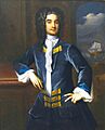
William Byrd II, who founded Richmond, was born in Henrico.


See also
 In Spanish: Condado de Henrico para niños
