Chesterfield County, Virginia facts for kids
Quick facts for kids
Chesterfield County
|
|||
|---|---|---|---|
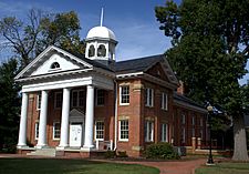
Old Chesterfield County Courthouse
|
|||
|
|||
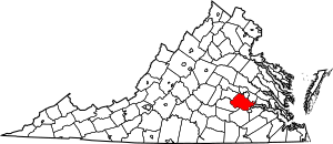
Location within the U.S. state of Virginia
|
|||
 Virginia's location within the U.S. |
|||
| Country | |||
| State | |||
| Founded | May 25, 1749 | ||
| Named for | |||
| Seat | Chesterfield Court House | ||
| Largest community | Chester | ||
| Area | |||
| • Total | 437 sq mi (1,130 km2) | ||
| • Land | 423 sq mi (1,100 km2) | ||
| • Water | 14 sq mi (40 km2) 3.1% | ||
| Population
(2020)
|
|||
| • Total | 364,548 | ||
| • Density | 834.2/sq mi (322.1/km2) | ||
| Time zone | UTC−5 (Eastern) | ||
| • Summer (DST) | UTC−4 (EDT) | ||
| Congressional districts | 4th, 1st | ||
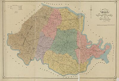
Chesterfield County is a county located just south of Richmond in the state of Virginia. The James River forms its northern border, and the Appomattox River forms its southern border. The main town and government center is Chesterfield Court House.
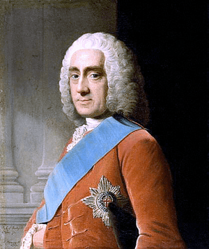
Chesterfield County was created in 1749 from parts of Henrico County. It was named after Philip Stanhope, 4th Earl of Chesterfield, an important English leader.
As of the 2020 census, about 364,548 people lived here. This makes it the fourth-most populated county in Virginia. Chesterfield County is part of the larger Greater Richmond Region.
Contents
- Exploring Chesterfield County's Past
- Getting Around Chesterfield County
- Planning for the Future
- Chesterfield County's Economy
- Chesterfield County's Geography
- People and Population
- Sister Communities
- Awards and Recognition
- Learning in Chesterfield County
- Communities in Chesterfield County
- Famous People from Chesterfield County
- Images for kids
- See also
Exploring Chesterfield County's Past
Early Settlements and Challenges
In the early 1600s, soon after Jamestown was settled in 1607, English colonists began exploring other areas. One important settlement was Henricus, founded by Sir Thomas Dale. It was planned to have a college for both Virginia Indians and settlers' children.
Dale described the area as a "convenient, strong, healthie and sweete site." It was on a piece of land with about 5,000 acres and a 7-mile shoreline on the James River. The settlers built a palisade (a fence of strong posts) and a ditch to protect the town.
Dale named the new settlement Henricus to honor Henry Frederick, Prince of Wales, the son of King James I. By 1619, "Henricus Citie" had houses, a church, and other buildings. This year was important for the Virginia Colony. The first ironworks in what is now the United States, Falling Creek Ironworks, was also built nearby. However, in 1622, Native Americans attacked and destroyed Henricus City and the ironworks. These settlements were never rebuilt.
In 1634, the King of England divided the Virginia colony into eight shires (or counties). One of these was Henrico County, which covered a large area on both sides of the James River.
How Chesterfield County Was Formed
On May 25, 1749, the Virginia House of Burgesses decided to separate Chesterfield from Henrico County. This created the new county. The first county seat (government center) was set up at Chesterfield Court House. This place has remained the county seat ever since, except for a few years during the Reconstruction period (1870–1876).
The county was named after Philip Stanhope, 4th Earl of Chesterfield. He was a British leader known for his good manners.
In 1939, during the Great Depression, the Virginia State Police moved their main offices to Chesterfield County. They built a new headquarters and training academy there later.
Early Transportation and Industry
Before the American Revolutionary War, a busy port town called Warwick was located where Falling Creek meets the James River. It was destroyed during the war and never rebuilt. Another early port was Port Walthall on the Appomattox River.
Coal mining started in the Midlothian area of Chesterfield County in the 1700s. French settlers found coal around 1701. By the 1730s, coal was being mined for sale. This coal was used to make cannons during the American Revolutionary War. In 1831, the Chesterfield Railroad was built. It used gravity and mules to transport coal to Manchester, Virginia (now part of Richmond) on the James River.
Rivers were important for transportation. The Appomattox River connected to the Upper Appomattox Canal Navigation System, and the James River and Kanawha Canal connected areas far to the west.
The Manchester Turnpike, finished in 1807, was Virginia's first long paved road. This toll road carried coal from Midlothian to the port of Manchester. Today, Midlothian Turnpike (U.S. Route 60) follows much of this old route.
In the 1800s, the state helped fund new roads and canals. Claudius Crozet, a civil engineer, helped plan and build many of these projects, including canals, turnpikes, bridges, and railroads.
By the 1850s, new railroads like the Richmond and Danville Railroad and the Richmond and Petersburg Railroad were built. These railroads were very important for moving supplies and soldiers during the American Civil War.
The Clover Hill Railroad was built to carry coal from the Clover Hill Pits to Osborne's Landing. Later, this railroad was changed and extended, eventually becoming the Tidewater and Western Railroad. Parts of the old rail bed can still be seen near Pocahontas State Park.
Chesterfield During the Civil War
During the American Civil War (1861–1865), Drewry's Bluff in Chesterfield County was a key defense point. It stopped the Union Navy from reaching Richmond by the James River. During the Siege of Petersburg (1864–65), a long line of defenses ran through the county. The railroads in Petersburg were crucial, and their capture in 1865 led to the fall of Richmond and the end of the war.
Changes After the War
After the Civil War, a school was founded in the Ettrick area to help educate formerly enslaved people. This school later became Virginia State University.
The Richmond and Danville Railroad became part of the Southern Railway in 1894, and is now part of Norfolk Southern Railway. The Richmond and Petersburg Railroad became part of the Atlantic Coast Line Railroad. Today, parts of these lines are used by CSX Transportation.
Areas That Became Independent Cities
Manchester, located across the James River from Richmond, was the county seat of Chesterfield from 1870 to 1876. In 1874, Manchester became an independent city and later joined the City of Richmond in 1910. It is now known as part of South Richmond.
Colonial Heights was once a town within Chesterfield County. It became an independent city in 1948. Even today, these two areas sometimes share government services.
Boundary Changes and Laws
Chesterfield County shares borders with three independent cities. For a long time, these cities could try to take parts of the county through a process called annexation. The county lost land to Richmond several times, including in 1944.
In 1970, Richmond tried to annex a large part of Chesterfield County. This caused a lot of disagreement. Leaders from both areas made a deal, and Richmond annexed about 23 square miles of the county. This included schools, fire stations, and other public services. Many residents in the annexed area were unhappy about this change.
Because of these issues, Virginia changed its annexation laws. In 1981, Chesterfield County was granted special protection, making it permanently safe from further annexation by Richmond. In 1987, the state put a temporary stop to all county annexations by cities.
Getting Around Chesterfield County
Since the mid-1900s, Chesterfield has grown a lot as a place where people live and travel to Richmond for work. Old electric train lines and local streetcar services ended by 1957.
Most people in Chesterfield County use their own cars to get around. The county has not funded public bus services like those in Richmond and Petersburg. This means residents rely heavily on cars, and there are not many sidewalks along roads.
The Virginia Department of Transportation (VDOT) builds and maintains highways. The Richmond-Petersburg Turnpike, a toll road opened in 1958, helped connect Richmond and Petersburg. It became toll-free in 1992 and is now a key part of Interstate 95.
The Powhite Parkway Extension, a toll road operated by VDOT, opened in 1988. It helps drivers travel west of Richmond and through the Midlothian area. This parkway now has a modern toll system that allows drivers with a Smart Tag or E-Z Pass to drive through without stopping.
The Pocahontas Parkway (State Route 895) is another 8.8-mile toll road. It connects Interstate 95 in Chesterfield with Interstate 295 near Richmond International Airport. This road includes the tall Vietnam Veterans Memorial Bridge over the James River, allowing large ships to pass underneath.
In 2020, the Greater Richmond Transit Company (GRTC) started a new bus line (Route 111) in Chesterfield County. The Virginia Department of Transportation (VDOT) is also planning new road improvements to help with traffic.
Planning for the Future
The Chesterfield County Planning Department helps guide how the county grows and develops. They oversee new projects and manage the county's Master Plan. In 2020, they launched an online system for submitting and reviewing development plans.
The county also created a tool in 2020 to track information about its capital improvement plan, including details about school enrollment.
Chesterfield County's Economy
The Chesterfield Economic Development Authority (CEDA) works to create new jobs, increase the tax base, and make the county's economy stronger. CEDA can buy and sell land for business parks, build facilities for companies, and offer help to attract new businesses or help existing ones grow.
In 2024, a company called Commonwealth Fusion Systems announced plans to build the world’s first large-scale commercial fusion power plant in the county. This is a big step for clean energy!
Top Private Employers
| EMPLOYER | INDUSTRY |
|---|---|
| Amazon Fulfillment Services | Administrative and Support Services |
| HCA Virginia Health System | Hospitals |
| United Parcel Service | Couriers and Messengers |
| Walmart | General Merchandise Stores |
| DuPont Specialty Products USA, LLC | Chemical Manufacturing |
| Kroger | Food and Beverage Stores |
| Bon Secours Richmond Health System | Hospitals |
| Food Lion | Food and Beverage Stores |
| Capital One | Credit Services |
| Integrity Staffing Solutions | Administrative and Support Services |
| Interpsan Inc | Administrative and Support Services |
| Maximus Services LLC | Administrative and Support Services |
| Lowe's | Home Improvement Stores |
| Atlantic Constructors Inc | Construction |
| Virginia Credit Union, Inc. | Credit Services |
| Hill Phoenix | Machinery Manufacturing |
| Sabra Dipping Co LLC | Food Wholesalers |
| YMCA | Non-profit Organizations |
| Results Customer Solution | Administrative and Support Services |
| The Home Depot | Home Improvement Stores |
| Xerox State Healthcare | Data Processing |
| Wawa (company) | Gasoline Stations |
| Target Corporation | General Merchandise Stores |
| Old Dominion Insulation Inc | Specialty Trade Contractors |
| Abilene Motor Express Inc | Truck Transportation |
Chesterfield County's Geography
According to the U.S. Census Bureau, Chesterfield County covers about 437 square miles. About 423 square miles are land, and 14 square miles (3.1%) are water.
The county is mostly bordered by two rivers: the James River to the north and the Appomattox River to the south. These rivers have "fall lines" where the land changes from hilly to flat. This change creates rapids, which were natural stopping points for ships.
Richmond and Manchester grew up at the fall line of the James River. Much of northern Chesterfield County is considered part of Richmond's "South Side." The Appomattox River forms the southern border, and parts of southern and eastern Chesterfield are considered part of the Tri-Cities area, which includes Petersburg.
Neighboring Areas
|
|
Protected Natural Areas
Main Roads and Highways
|
|
|
People and Population
| Historical population | |||
|---|---|---|---|
| Census | Pop. | %± | |
| 1790 | 14,214 | — | |
| 1800 | 14,488 | 1.9% | |
| 1810 | 9,979 | −31.1% | |
| 1820 | 18,003 | 80.4% | |
| 1830 | 18,637 | 3.5% | |
| 1840 | 17,148 | −8.0% | |
| 1850 | 17,489 | 2.0% | |
| 1860 | 19,016 | 8.7% | |
| 1870 | 18,470 | −2.9% | |
| 1880 | 25,085 | 35.8% | |
| 1890 | 26,211 | 4.5% | |
| 1900 | 18,804 | −28.3% | |
| 1910 | 21,299 | 13.3% | |
| 1920 | 20,496 | −3.8% | |
| 1930 | 26,049 | 27.1% | |
| 1940 | 31,183 | 19.7% | |
| 1950 | 40,400 | 29.6% | |
| 1960 | 71,197 | 76.2% | |
| 1970 | 76,855 | 7.9% | |
| 1980 | 141,372 | 83.9% | |
| 1990 | 209,274 | 48.0% | |
| 2000 | 259,903 | 24.2% | |
| 2010 | 316,236 | 21.7% | |
| 2020 | 364,548 | 15.3% | |
| 2023 (est.) | 383,876 | 21.4% | |
| U.S. Decennial Census 1790–1960 1900–1990 1990–2000 2010 2020 |
|||
Population in 2020
| Race / Ethnicity (NH = Not Hispanic) | Pop 2010 | Pop 2020 | % 2010 | % 2020 |
|---|---|---|---|---|
| White alone (NH) | 206,792 | 210,881 | 65.39% | 57.85% |
| Black or African American alone (NH) | 68,196 | 81,492 | 21.56% | 22.35% |
| Native American or Alaska Native alone (NH) | 849 | 848 | 0.27% | 0.23% |
| Asian alone (NH) | 10,219 | 13,096 | 3.23% | 3.59% |
| Pacific Islander alone (NH) | 142 | 177 | 0.04% | 0.05% |
| Some Other Race alone (NH) | 606 | 2,098 | 0.19% | 0.58% |
| Mixed Race or Multi-Racial (NH) | 6,568 | 15,720 | 2.08% | 4.31% |
| Hispanic or Latino (any race) | 22,864 | 40,236 | 7.23% | 11.04% |
| Total | 316,236 | 364,548 | 100.00% | 100.00% |
Population in 2010
In 2010, there were 316,236 people living in the county. The population density was about 610 people per square mile.
The racial makeup of the county was mostly White (68.3%) and Black or African American (21.9%). About 7.2% of the population was Hispanic or Latino.
The largest ancestry groups included African American (18%), English (14.5%), German (12.5%), and Irish (11%).
About 26.1% of the population was under 18 years old. The average age was 37.6 years.
Sister Communities
In 2005, Chesterfield County formed a special "sister community" relationship with the Borough of Gravesham in Kent, England. The town of Gravesend is part of this borough. This is where Pocahontas was buried after she died during a trip to England. It is believed that Matoaca in Chesterfield County was her home village in North America. This partnership celebrated the founding of Jamestown in 2007.
Awards and Recognition
In May 2004, Chesterfield was named the "17th Best Place to Live in America" by the American City Business Journals.
Since 2009, the National Association of Counties (NACo) has given Chesterfield County many National Achievement Awards. These awards recognize counties for their excellent programs and services. Chesterfield County has won many awards each year, including 14 in 2020 for programs like:
- Access on Demand and My Chesterfield Academy for citizen information.
- First Responders and Multicultural Community Cup for parks and recreation.
- Museum Pass Bag and Thinking Money for Kids for libraries.
- Legacy Lane from the Sheriff's Office.
- Call Center Training Program for Utilities.
Learning in Chesterfield County
Chesterfield County Public Schools is the local school system. It has received the U.S. Department of Education's Blue Ribbon Award, which means it's a great school system!
Chesterfield County has over sixty public schools. There are 40 elementary schools, 12 middle schools, and 10 high schools. There are also 3 technical schools for high school students. Each high school offers special programs in areas like math and science, health science, international studies, leadership, and visual and performing arts. The Career and Technical Center helps high school students prepare for future jobs and college with hands-on training in fields like automotive, construction, engineering, and public safety.
The Chesterfield Public Education Foundation, started in 1989, helps raise extra money for the schools. They fund programs for students and teachers, and offer scholarships.
The Chesterfield County Public Library system was started in 1964 and now has 10 branches across the county.
Brightpoint Community College, a two-year college, has two campuses in Chesterfield County: one in Chester and one in Midlothian.
Chesterfield County is also home to Virginia State University, a historically Black University located in Ettrick.
Communities in Chesterfield County
Chesterfield County does not have any officially incorporated towns.
Census-Designated Places
These are areas that the U.S. Census Bureau defines for statistical purposes.
Other Communities
These are other smaller communities within the county.
- Belmont
- Bermuda Hundred
- Chesterfield Court House
- Deer Run
- Genito
- Gordon
- Hampton Park
- Harrowgate
- Hening
- Jefferson Davis North
- Midlothian
- Moseley
- Reams
- Robious
- Salisbury
- Skinquarter
- South Rockwood
- Spring Run
- Winterpock
Many of these areas used to have Richmond or Colonial Heights mailing addresses. Recently, they were changed to "North Chesterfield" or "South Chesterfield" addresses to avoid confusion with city taxes. However, most of Ettrick still uses a Petersburg mailing address.
Famous People from Chesterfield County
- Denny Hamlin (b. 1980) – A famous NASCAR race car driver.
- Mark Parson (b. 1986) – A former NFL football player.
- Young M.A (b. 1992) – A well-known rapper.
- Devin Robinson (b. 1995) – An NBA basketball player.
- Devin Druid (b. 1998) – An actor known for the TV show 13 Reasons Why.
- Keldon Johnson (b. 1999) – An NBA basketball player.
Images for kids
See also
 In Spanish: Condado de Chesterfield (Virginia) para niños
 | Tommie Smith |
 | Simone Manuel |
 | Shani Davis |
 | Simone Biles |
 | Alice Coachman |


