Dinwiddie County, Virginia facts for kids
Quick facts for kids
Dinwiddie County
|
|||
|---|---|---|---|

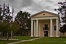
Dinwiddie County's historic courthouse
|
|||
|
|||

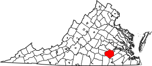
Location within the U.S. state of Virginia
|
|||
 Virginia's location within the U.S. |
|||
| Country | |||
| State | |||
| Founded | 1752 | ||
| Named for | Robert Dinwiddie | ||
| Seat | Dinwiddie | ||
| Largest town | McKenney | ||
| Area | |||
| • Total | 507 sq mi (1,310 km2) | ||
| • Land | 504 sq mi (1,310 km2) | ||
| • Water | 3.5 sq mi (9 km2) 0.7% | ||
| Population
(2020)
|
|||
| • Total | 27,947 | ||
| • Density | 55.12/sq mi (21.283/km2) | ||
| Time zone | UTC−5 (Eastern) | ||
| • Summer (DST) | UTC−4 (EDT) | ||
| Congressional district | 4th | ||
Dinwiddie County is a county located in the state of Virginia. In 2020, about 27,947 people lived there. The main town and county seat is Dinwiddie.
Dinwiddie County is part of the larger Richmond area.
Contents
History of Dinwiddie County

The first people to live in this area were Paleo-Indians. This was before 8000 BC. They were likely nomadic hunter-gatherers, meaning they moved around to hunt animals and gather food. Old stone tools have been found in fields across the county. When Europeans first arrived, Native American tribes lived here.
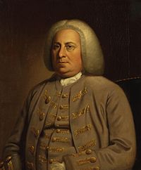
Dinwiddie County was officially formed on May 1, 1752. It was created from a part of Prince George County. The county got its name from Robert Dinwiddie. He was the Lieutenant Governor of Virginia from 1751 to 1758. People from the county formed groups of soldiers to fight in the American Revolution.
Dinwiddie County is also the birthplace of some important people. Elizabeth (Burwell) Hobbs Keckly was born here. She was a free Black dressmaker. She made clothes for the wives of two presidents: Mrs. Jefferson Davis and later Mary Todd Lincoln. Thomas Day was another famous person from Dinwiddie. He became a well-known free Black cabinetmaker in North Carolina. Dr. Thomas Stewart, who might have been America's first free Black country doctor in the 1700s, also came from here.
During the American Civil War, several battles took place in Dinwiddie County. One important battle was the Battle of Lewis's Farm. It happened on March 29, 1865. This was part of a plan by Union General Ulysses S. Grant. He wanted to cut off the last supply line for Confederate General Robert E. Lee's army. Union soldiers fought against Confederate soldiers. After some intense fighting, the Union troops dug in nearby. The Confederates then moved back to their lines. Four days later, the Union army cut the railway line. This happened after they won the Battle of Five Forks on April 1, 1865.
The Dinwiddie County Historical Society is now located in the old Dinwiddie County Court House.
Civil War Battles in Dinwiddie County
Many battles happened in Dinwiddie County during the Civil War, including:
- Battle of Peebles' Farm
- Battle of Lewis's Farm
- Battle of Dinwiddie Court House
- Battle of White Oak Road
- Battle of Five Forks
- Battle of Sutherland's Station
Geography of Dinwiddie County
Dinwiddie County is in southern Virginia. It is southwest of the city of Petersburg. Petersburg became a separate city in 1871. The county has a total area of about 507 square miles. Most of this is land (504 square miles), and a small part is water (3.5 square miles). It is located between two U.S. Army bases: Fort Gregg-Adams to the east and Fort Barfoot to the west.
Counties Next to Dinwiddie
Dinwiddie County shares borders with these counties:
- Chesterfield County – to the north
- Petersburg City – to the northeast
- Prince George County – to the east
- Sussex County – to the southeast
- Greensville County – to the south
- Brunswick County – to the southwest
- Nottoway County – to the west
- Amelia County – to the northwest
Protected Areas
A part of the Petersburg National Battlefield is located in Dinwiddie County.
Main Roads in Dinwiddie County
Important highways that go through Dinwiddie County include:
 I-85
I-85 US 1
US 1 US 460


 US 460 Bus.
 SR 40
SR 40 SR 142
 SR 226
Population Changes in Dinwiddie County
| Historical population | |||
|---|---|---|---|
| Census | Pop. | %± | |
| 1790 | 13,934 | — | |
| 1800 | 15,374 | 10.3% | |
| 1810 | 18,190 | 18.3% | |
| 1820 | 20,482 | 12.6% | |
| 1830 | 21,901 | 6.9% | |
| 1840 | 22,558 | 3.0% | |
| 1850 | 25,118 | 11.3% | |
| 1860 | 30,198 | 20.2% | |
| 1870 | 30,702 | 1.7% | |
| 1880 | 32,870 | 7.1% | |
| 1890 | 13,515 | −58.9% | |
| 1900 | 15,374 | 13.8% | |
| 1910 | 15,442 | 0.4% | |
| 1920 | 17,949 | 16.2% | |
| 1930 | 18,492 | 3.0% | |
| 1940 | 18,166 | −1.8% | |
| 1950 | 18,839 | 3.7% | |
| 1960 | 22,183 | 17.8% | |
| 1970 | 25,046 | 12.9% | |
| 1980 | 22,602 | −9.8% | |
| 1990 | 20,960 | −7.3% | |
| 2000 | 24,533 | 17.0% | |
| 2010 | 28,001 | 14.1% | |
| 2020 | 27,947 | −0.2% | |
| 2021 (est.) | 27,912 | −0.3% | |
| U.S. Decennial Census 1790–1960 1900–1990 1990–2000 2010 2020 |
|||
Towns and Communities
For counting purposes, the cities of Petersburg and Colonial Heights are often grouped with Dinwiddie County.
Town
Census-Designated Places
These are areas that are like towns but are not officially incorporated as towns:
- Dinwiddie (this is the county seat)
Other Communities
These are smaller communities that are not officially incorporated:
Education
The Appomattox Regional Library provides public library services for the people in Dinwiddie County.
See also
 In Spanish: Condado de Dinwiddie para niños
 | Anna J. Cooper |
 | Mary McLeod Bethune |
 | Lillie Mae Bradford |


