
Amelia County, Virginia facts for kids
Quick facts for kids
Amelia County
|
||
|---|---|---|

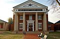
Amelia County Court House
|
||
|
||

Location within the U.S. state of Virginia
|
||
 Virginia's location within the U.S. |
||
| Country | ||
| State | ||
| Founded | 1735 | |
| Named for | Princess Amelia | |
| Seat | Amelia Court House | |
| Area | ||
| • Total | 359 sq mi (930 km2) | |
| • Land | 355 sq mi (920 km2) | |
| • Water | 3.3 sq mi (9 km2) 0.9% | |
| Population
(2020)
|
||
| • Total | 13,265 | |
| • Density | 36.95/sq mi (14.266/km2) | |
| Demonym(s) | Amelian, Amellianaire | |
| Time zone | UTC−5 (Eastern) | |
| • Summer (DST) | UTC−4 (EDT) | |
| ZIP Codes |
23002, 23083, 23105
|
|
| Congressional district | 5th | |

Amelia County is a county located in the state of Virginia, United States. It is found southwest of Richmond. The county is part of the larger Greater Richmond Region. Its main town and government center is Amelia Court House.
Amelia County was formed in 1735. It was created from parts of two other counties, Prince George and Brunswick. The county was named after Princess Amelia of Great Britain. Later, parts of Amelia County were used to create Prince Edward and Nottoway counties.
In 2020, about 13,265 people lived in Amelia County.
Contents
- History of Amelia County
- Geography of Amelia County
- Getting Around Amelia County
- Population of Amelia County
- Fun Events and Places in Amelia County
- News in Amelia County
- Schools in Amelia County
- Communities in Amelia County
- Historic Places in Amelia County
- Famous People from Amelia County
- Images for kids
- See also
History of Amelia County
_by_Jean-Baptiste_van_Loo.jpg)
Amelia County was officially created by law in 1734 and 1735. It was formed from land that used to be part of Prince George and Brunswick counties. The county got its name from Princess Amelia of Great Britain. She was the daughter of King George II.
Over time, as more people moved into the area, Amelia County's size was reduced. This happened when new counties were formed from its land. For example, Prince Edward County was created in 1754. Later, Nottoway County was formed in 1789. In the past, the area was known for large farms. These farms relied on the labor of enslaved people.
During the Civil War, Confederate General Robert E. Lee and his army stayed in Amelia Court House on April 4 and 5, 1865. This was just before his surrender on April 9. The last big battle for his army happened at Sayler's Creek. This battle took place on April 6, on the border of Amelia and Prince Edward counties.
Amelia County is famous for its special minerals. It has some of the best amazonite in the country. Amazonite is a green mineral found at the Morefield mine. In the 1800s, people built health resorts around the county's mineral springs. These places were popular spots for travelers to visit.
In 1986, the Amelia County Fair held a fun contest. They made the world's largest potato pancake! It was made to raise money for a scholarship fund. The giant pancake weighed more than two and a quarter tons. It took four truckloads of potatoes to make it.
Geography of Amelia County
Amelia County covers a total area of about 359 square miles. Most of this area, about 355 square miles, is land. The remaining 3.3 square miles, or 0.9%, is water.
The county is located in the Piedmont region of Virginia. This area has rolling hills and small ridges. These hills are found between the Blue Ridge Mountains and the Coastal Plain of Virginia. The Appomattox River forms the northern and western borders of the county. Namozine Creek is on the eastern side.
Rivers and streams that flow into the Appomattox River drain Amelia County. The lowest point in the county is 158 feet high. This is on Lake Chesdin, which is part of the Appomattox River. The highest point is 525 feet high. This spot is near the community of Gills.
Neighboring Counties
- Powhatan County – to the north
- Chesterfield County – to the east
- Dinwiddie County – to the southeast
- Nottoway County – to the south
- Prince Edward County – to the southwest
- Cumberland County – to the west
Getting Around Amelia County
Air Travel
- Richmond International Airport is about 51 miles northeast of Amelia County.
Main Highways
 US 360 (Patrick Henry Highway) goes east to Richmond. It goes west to Burkeville and Danville.
State Roads
 SR 38 (Virginia Street, Court Street, Washington Street, Church Street, Five Forks Road) runs through Amelia Court House.
 SR 153 (Military Road) connects to
  US 460 and Blackstone.
 SR 307 (Holly Farms Road) connects to US 460 and Farmville.
Local Roads
 SR 604 (Chula Rd and Genito Rd) goes to Powhatan and Chesterfield Counties.
 SR 609 (Grub Hill Church Rd and Royalton Rd) goes to
  US 60 and Powhatan Court House.
 SR 614 (Dennisville Rd) goes to Blackstone.
 SR 616 (Genito Rd) serves the northwest and southwest parts of Amelia County. It connects to SR 307 near Rice.
Train Service
- Norfolk Southern provides freight train services.
Population of Amelia County
| Historical population | |||
|---|---|---|---|
| Census | Pop. | %± | |
| 1790 | 18,097 | — | |
| 1800 | 9,432 | −47.9% | |
| 1810 | 10,594 | 12.3% | |
| 1820 | 11,104 | 4.8% | |
| 1830 | 11,036 | −0.6% | |
| 1840 | 10,320 | −6.5% | |
| 1850 | 9,770 | −5.3% | |
| 1860 | 10,741 | 9.9% | |
| 1870 | 9,878 | −8.0% | |
| 1880 | 10,377 | 5.1% | |
| 1890 | 9,068 | −12.6% | |
| 1900 | 9,037 | −0.3% | |
| 1910 | 8,720 | −3.5% | |
| 1920 | 9,800 | 12.4% | |
| 1930 | 8,799 | −10.2% | |
| 1940 | 8,495 | −3.5% | |
| 1950 | 7,908 | −6.9% | |
| 1960 | 7,815 | −1.2% | |
| 1970 | 7,592 | −2.9% | |
| 1980 | 8,405 | 10.7% | |
| 1990 | 8,787 | 4.5% | |
| 2000 | 11,400 | 29.7% | |
| 2010 | 12,690 | 11.3% | |
| 2020 | 13,265 | 4.5% | |
| 2021 (est.) | 13,268 | 4.6% | |
| U.S. Decennial Census 1790-1960 1900-1990 1990-2000 2010 2020 |
|||
As of the 2020 census, Amelia County had a population of 13,265 people.
Fun Events and Places in Amelia County
Yearly Events
- Amelia Day is a county-wide festival held every May. It takes place on the Saturday before Mother's Day in Amelia Court House. The festival started in the 1980s to celebrate the town's founding. People enjoy music, dancing, and meeting up with friends. At the first Amelia Day in 1985, residents signed a long paper. This paper and other items were put into a time capsule. The capsule was buried near the courthouse. It is planned to be opened in 2035.
- The Amelia County Fair happens every year in late summer or early fall. It is held at the Joe Paulette Memorial Park in Amelia Court House.
- Each October, the Amelia Frightfest opens at Tom Scott Park. It is a spooky trail for fun.
- From April to October, on the second Saturday of each month, the Time Bandits car club hosts a car show. It takes place at the Truist Bank parking lot.
Places to Visit
- Sayler's Creek Battlefield State Park is a historic site.
- Lake Chesdin is a large lake for recreation.
- Amelia Wildlife Management Area is a place for nature and wildlife.
- Amelia Country Club is a local club.
News in Amelia County
The Amelia Bulletin Monitor is a weekly newspaper. It has been covering news in the county since 1973.
Schools in Amelia County
Public Schools
Amelia County has its own public school system.
- Amelia County High School
- Amelia County Middle School
- Amelia County Elementary School
Private Schools
- Amelia Academy is a private school in the county.
Communities in Amelia County
Amelia County does not have any incorporated towns or cities.
Main Community
- Amelia Court House is a census-designated place. This means it is a community recognized by the census bureau.
Other Communities
- Ammon
- Chula
- Clementown Mills
- Coverly
- Deatonville
- Denaro
- Earls
- Fieldstown
- Giles Mill
- Gills
- Haw Branch
- Jetersville
- Little Patrick
- Lodore
- Mannboro
- Maplewood
- Masons Corner
- Mattoax
- Morven
- Namozine
- Otterburn
- Paineville
- Pontons/Ponton's/Pointons Store
- Rodophil
- Scotts Fork
- Truxillo
- Winterham
Historic Places in Amelia County
Many sites in Amelia County are listed on the National Register of Historic Places. This means they are important historical locations.
- Barrett–Chumney House
- Dykeland
- Egglestetton
- Farmer House
- Haw Branch
- Ingleside
- St. John's Church (Grub Hill Church)
- Sayler's Creek Battlefield
- Wigwam
- Winterham Plantation
Famous People from Amelia County
- William S. Archer (born in Amelia County), a United States Senator from Virginia.
- Van T. Barfoot (1919–2012), a U.S. Army Colonel and a Medal of Honor winner.
- William Wyatt Bibb (born in Amelia County), a United States Senator from Georgia and the first Governor of Alabama.
- Jesse Bragg, a baseball player in the Negro leagues.
- William Cocke (1747–1828) (born in Amelia County), the first United States Senator from Tennessee.
- Henry William Connor (1793–1866) (born near Amelia Court House), a United States Congressman from North Carolina.
- Rosa Dixon Bowser (1855-1931) (born in Amelia County), the first African American teacher hired in Richmond, Virginia. She helped start the Virginia State Teachers Association.
- David Fanning (1755–1825) (born in Amelia County), a Loyalist officer during the American Revolutionary War.
- William Branch Giles (1762–1830) (born in Amelia County), a planter, United States Congressman, United States Senator, and Governor of Virginia.
- David Greenhill, a member of the Colonial House of Burgesses.
- Edmund Harrison (1764–1826), Speaker of the Virginia House of Delegates.
- John Winston Jones (1791–1848) (born in Amelia County), Speaker of the United States House of Representatives.
- Nellie A. Ramsey Leslie (c.1840s–c.1920s) (born into slavery in Amelia County), a musician, teacher, and composer.
- Robert Russa Moton (1867–1940), a well-known African American educator. He was born in Amelia County.
- Mary Virginia Terhune (1830–1922) (born in Amelia County), a popular author. She was the first woman elected to the Virginia Historical Society.
Images for kids
-
Amelia County Court House
See also
 In Spanish: Condado de Amelia para niños
