Namozine, Virginia facts for kids
Quick facts for kids
Namozine, Virginia
|
|
|---|---|

Namozine Presbyterian Church
|
|
| Country | United States |
| State | Virginia |
| County | Amelia |
| Elevation | 280 ft (90 m) |
| Time zone | UTC−5 (Eastern (EST)) |
| • Summer (DST) | UTC−4 (EDT) |
| ZIP codes |
23850, 23833, 23002
|
| Area code(s) | 804 |
| GNIS feature ID | 1690039 |
Namozine is a small, quiet place in the countryside of Amelia County, Virginia. It's not a city or town with its own government. Instead, it's an unincorporated community, which means it's a group of homes and businesses that are part of the larger county. Namozine is located near the Appomattox River.
Contents
What is Namozine?
Namozine is in the eastern part of Amelia County. It's found where several roads meet, like Namozine Road and Chesdin Lake Road. A nearby stream, Namozine Creek, flows into the Appomattox River at Lake Chesdin. This creek also helps form the county line.
Mail and Services
The community of Namozine uses several different ZIP codes for mail. This is because the area is served by post offices in nearby places like Ford and Church Road. A small part of Namozine even gets its mail from Amelia Court House, which is the main town of the county.
The closest volunteer fire station is about 6 miles away in Mannboro. There is another fire station called "Namozine Volunteer Fire & EMS Co. 4," but it's actually much farther away, near Petersburg.
Namozine's History
The name "Namozine" is very old. It has been around since at least 1712. People think the name was first used for the creek before it was used for the community itself. The name has changed a bit over time, with older spellings like "Nummisseen" or "Nammisseen."
Early Days and Stores
The community might have been called Terrapin Creek until 1841. It became a post village (a place with a post office) called Namozine in 1841. Even during the Civil War, there was a business called Whites Store in the area. This store was so well known that some old maps showed the spot as "Whites Store" instead of Namozine.
In the 1900s, a business called Namozine Country Store was a popular spot. It was owned by the same family for many years before it closed in 2010. It was one of the last stores of its kind in the area.
Historic Churches
Namozine is home to several historic churches that have played an important role in the community.
Namozine Presbyterian Church
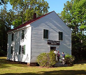
The historic Namozine Presbyterian Church was built in 1847. It stands at the intersection of Namozine Road and Mill Quarter Road. A famous person named Rev. Richard McIlwaine, who later became the eleventh president of Hampden–Sydney College, was a pastor here before the Civil War began.
The Battle of Namozine Church
During the final days of the Civil War, a battle known as the Battle of Namozine Church took place right here. The church building itself was used as a hospital by both sides during the fighting. It's amazing that the church survived the battle and looks almost the same today as it did when it was built. A historical marker at the church tells more about this event.
Namozine Presbyterian Church, built in 1847, fortunately survived the battle. It remains virtually unchanged since its date of construction.
Other Churches
Another important church in Namozine is Union Baptist. This is an African American church with a special red-brick building. It's located less than half a mile east of the Presbyterian church, also on Namozine Road.
Old Roads
In the early 1900s, a part of Virginia State Route 38 used to go through Namozine, passing by both the Presbyterian and Baptist churches. This section of the highway was later changed in 1951 to what is now Route 708.
 | Anna J. Cooper |
 | Mary McLeod Bethune |
 | Lillie Mae Bradford |


