Powhatan County, Virginia facts for kids
Quick facts for kids
Powhatan County
|
|||
|---|---|---|---|

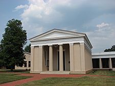
Powhatan County Courthouse
|
|||
|
|||

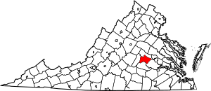
Location within the U.S. state of Virginia
|
|||
 Virginia's location within the U.S. |
|||
| Country | |||
| State | |||
| Founded | 1777 | ||
| Named for | Powhatan | ||
| Seat | Powhatan | ||
| Area | |||
| • Total | 262 sq mi (680 km2) | ||
| • Land | 260 sq mi (700 km2) | ||
| • Water | 2.1 sq mi (5 km2) 0.8% | ||
| Population
(2020)
|
|||
| • Total | 30,033 | ||
| • Density | 114.63/sq mi (44.26/km2) | ||
| Time zone | UTC−5 (Eastern) | ||
| • Summer (DST) | UTC−4 (EDT) | ||
| Congressional district | 5th | ||
Powhatan County (/ˈpaʊ.həˈtæn/) is a county located in Virginia. In 2020, about 30,033 people lived there. The main town, or county seat, is called Powhatan.
Powhatan County is part of the larger Greater Richmond Region. The James River forms the county's northern border. The Appomattox River is on the south side. The county is named after Chief Powhatan. He was a powerful leader of Native American tribes when the British settled at Jamestown in 1607. Before the British arrived, the Monacan people, who spoke Siouan languages, lived in this area. They moved west when more colonists arrived.
In 1700, French Huguenot refugees settled in an abandoned Monacan village. They called it Manakin Town. It was about 20 miles from the falls of the James River.
Contents
History of Powhatan County
Early Native American Villages
Long before Europeans came in the 1600s, different Native American tribes lived in Virginia. The Monacan tribe, who spoke Siouan languages, lived in the Piedmont area. They had several villages west of what became Manakin Town.
The Monacan people often fought with the Powhatan Confederacy. These tribes spoke Algonquian languages and lived closer to the coast. Tribes from the north, like the Iroquois, also raided the area. By the late 1600s, many Monacan people had died from wars and diseases brought by the colonists. The remaining Monacan joined other Siouan tribes.
Manakin Town Settlement
In 1700 and 1701, about 700-800 French Huguenot refugees came to Jamestown. They were escaping religious persecution in France. The British Crown had promised them land. Many of these refugees were merchants and skilled workers.
The governor, Francis Nicholson, and a wealthy planter, William Byrd II, offered the French 10,000 acres of land. This land was where the Monacan Indians had lived, about 20 miles up the James River. They wanted the French to settle there as a barrier between the English settlements and other Native American tribes. This area later became known as Manakin Town.
Life on the frontier was very hard for the French settlers. By 1705, only 150 of the original 390 French settlers were still there. The river's falls made it hard to travel downstream. There were no roads, so they were cut off from Jamestown. They ran out of supplies and struggled to farm the land.
The French settlers eventually became part of colonial Virginia. Services at their church slowly changed from French to English. Many Huguenot families married into English families. They also bought African slaves to work on their farms. Many descendants of these Huguenots later moved west into other parts of Virginia, Kentucky, and Tennessee.
Today, the 1895 Huguenot Memorial Chapel and Monument stands near the old town. It is a historic site. The nearby Manakin Episcopal Church still holds services for the community.
Forming Powhatan County
In May 1777, the Virginia General Assembly created Powhatan County. It was made from the eastern part of Cumberland County. The new county was named after Chief Powhatan. He was the father of Pocahontas, who was known for her interactions with the English colonists. She later married English settler John Rolfe.
For the first two years, Mosby Tavern was used as the county courthouse. A new courthouse was built in 1778. The area around it was named "Scottville" after General Charles Scott. He was a soldier in the American Revolutionary War. This courthouse area was later renamed Powhatan.
In the late 1700s and early 1800s, more large farms, called plantations, grew in the county. These farms used many Black American enslaved people to grow tobacco and other crops like wheat. After the Civil War, Powhatan County used workers to build roads.
The county mostly relied on farming until after World War II. Today, it still has rural areas and historic farms. However, new homes and shops are also being built.
Geography
Powhatan County covers about 262 square miles. Most of this is land, with about 2.1 square miles of water. The James River is to the north, and the Appomattox River is to the south.
Neighboring Counties
- Goochland County - north
- Chesterfield County - east
- Amelia County - south
- Cumberland County - west
- Henrico County - east (a small part of Powhatan touches Henrico)
Main Roads
 US 60
US 60 US 522
 SR 13
SR 13 SR 288
- SR 711
- SR 609
 SR 300
Population Data
| Historical population | |||
|---|---|---|---|
| Census | Pop. | %± | |
| 1790 | 6,822 | — | |
| 1800 | 7,769 | 13.9% | |
| 1810 | 8,073 | 3.9% | |
| 1820 | 8,292 | 2.7% | |
| 1830 | 8,517 | 2.7% | |
| 1840 | 7,924 | −7.0% | |
| 1850 | 8,178 | 3.2% | |
| 1860 | 8,392 | 2.6% | |
| 1870 | 7,667 | −8.6% | |
| 1880 | 7,817 | 2.0% | |
| 1890 | 6,791 | −13.1% | |
| 1900 | 6,824 | 0.5% | |
| 1910 | 6,099 | −10.6% | |
| 1920 | 6,552 | 7.4% | |
| 1930 | 6,143 | −6.2% | |
| 1940 | 5,671 | −7.7% | |
| 1950 | 5,556 | −2.0% | |
| 1960 | 6,747 | 21.4% | |
| 1970 | 7,696 | 14.1% | |
| 1980 | 13,062 | 69.7% | |
| 1990 | 15,328 | 17.3% | |
| 2000 | 22,377 | 46.0% | |
| 2010 | 28,046 | 25.3% | |
| 2020 | 30,033 | 7.1% | |
| 2021 (est.) | 31,136 | 11.0% | |
| U.S. Decennial Census 1790-1960 1900-1990 1990-2000 2010 2020 |
|||
How the Population Changed (2020 Census)
The table below shows the different groups of people living in Powhatan County in 2010 and 2020.
| Group | Number in 2010 | Number in 2020 | Percentage in 2010 | Percentage in 2020 |
|---|---|---|---|---|
| White (not Hispanic) | 23,231 | 25,497 | 82.83% | 84.06% |
| Black or African American (not Hispanic) | 3,798 | 2,477 | 13.54% | 8.17% |
| Native American or Alaska Native (not Hispanic) | 75 | 59 | 0.27% | 0.19% |
| Asian (not Hispanic) | 131 | 167 | 0.47% | 0.55% |
| Pacific Islander (not Hispanic) | 10 | 18 | 0.04% | 0.06% |
| Other Race (not Hispanic) | 16 | 99 | 0.06% | 0.33% |
| Mixed Race (not Hispanic) | 283 | 1,224 | 1.01% | 4.04% |
| Hispanic or Latino (any race) | 502 | 792 | 1.79% | 2.61% |
| Total Population | 28,046 | 30,033 | 100.00% | 100.00% |
Note: The US Census counts Hispanic/Latino as an ethnic group. People who are Hispanic/Latino can be of any race.
Education
Powhatan County Public Schools teaches over 4,300 students. There are three elementary schools: Pocahontas, Powhatan, and Flat Rock. These schools teach students from Kindergarten to 5th grade.
Powhatan Middle School was finished in 2018. It teaches 6th, 7th, and 8th grades. Powhatan High School is the only high school in the county. It teaches 9th through 12th grades. The current leader of the schools is Dr. Beth Teigen (as of 2022).
The School Board members are:
- District 1 and Vice Chairwoman: Vicki R. Hurt
- District 2: Susan Evans Smith
- District 3: Jeanne M. Wade
- District 4 and Chairman: James E. Taylor, III
- District 5: Michele Leite' Ward
The Roman Catholic Diocese of Richmond also oversees Catholic education in the county. The Blessed Sacrament Huguenot Catholic School in Powhatan teaches students from pre-kindergarten through 12th grade.
Famous People from Powhatan County
- William Henry Ashley: An American explorer and politician. He helped start the Rocky Mountain Fur Company.
- John Singleton Mosby: Born in Powhatan County, he was known as the "Gray Ghost." He was a cavalry commander for the Confederate army during the American Civil War. Later, he worked as a consul in Hong Kong and for the U.S. Department of Justice.
- Lynne Doughtie: A resident of Powhatan. She was the US Chairwoman and CEO of the accounting firm KPMG. Fortune Magazine named her one of the "Most Powerful Women."
See also
 In Spanish: Condado de Powhatan para niños
 | Misty Copeland |
 | Raven Wilkinson |
 | Debra Austin |
 | Aesha Ash |


