Cumberland County, Virginia facts for kids
Quick facts for kids
Cumberland County
|
|||
|---|---|---|---|

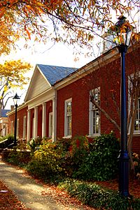
Cumberland County Courthouse
|
|||
|
|||

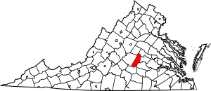
Location within the U.S. state of Virginia
|
|||
 Virginia's location within the U.S. |
|||
| Country | |||
| State | |||
| Founded | 1749 | ||
| Named for | William Augustus, Duke of Cumberland | ||
| Seat | Cumberland | ||
| Largest town | Farmville | ||
| Area | |||
| • Total | 300 sq mi (800 km2) | ||
| • Land | 297 sq mi (770 km2) | ||
| • Water | 2.3 sq mi (6 km2) 0.8% | ||
| Population
(2020)
|
|||
| • Total | 9,675 | ||
| • Density | 32/sq mi (12.5/km2) | ||
| Time zone | UTC−5 (Eastern) | ||
| • Summer (DST) | UTC−4 (EDT) | ||
| Congressional district | 5th | ||
Cumberland County is a county located in Virginia, United States. In 2020, about 9,675 people lived here. The main town and government center is Cumberland.
Contents
History of Cumberland County
Cumberland County was created in 1749. It was formed from a part of Goochland County. The county got its name from William Augustus. He was the third son of King George II of Great Britain.
For many years, from 1749 to 1777, Mosby Tavern served as the county courthouse. Later, a new county, Powhatan County, was formed from the eastern part of Cumberland. In 1778, a small area near the James River was added from Buckingham County.
Geography of Cumberland County
Cumberland County covers about 300 square miles. Most of this area is land, about 297 square miles. The rest, about 2.3 square miles, is water.
Neighboring Counties
Cumberland County shares borders with several other counties:
- Goochland County to the northeast
- Powhatan County to the east
- Amelia County to the southeast
- Prince Edward County to the south
- Buckingham County to the west
- Fluvanna County to the northwest
Main Roads
These are the major roads that go through Cumberland County:
 US 60
US 60 SR 13
SR 13 SR 45
SR 45
Population Changes in Cumberland County
For a long time, from 1880 to 1970, the number of people living in Cumberland County went down. This happened because new machines meant fewer workers were needed for farming. But since 1970, the population has started to grow again. In 2010, it was almost as high as it was in the 1800s.
| Historical population | |||
|---|---|---|---|
| Census | Pop. | %± | |
| 1790 | 8,153 | — | |
| 1800 | 9,839 | 20.7% | |
| 1810 | 9,992 | 1.6% | |
| 1820 | 11,023 | 10.3% | |
| 1830 | 11,690 | 6.1% | |
| 1840 | 10,399 | −11.0% | |
| 1850 | 9,751 | −6.2% | |
| 1860 | 9,961 | 2.2% | |
| 1870 | 8,142 | −18.3% | |
| 1880 | 10,540 | 29.5% | |
| 1890 | 9,482 | −10.0% | |
| 1900 | 8,996 | −5.1% | |
| 1910 | 9,195 | 2.2% | |
| 1920 | 9,111 | −0.9% | |
| 1930 | 7,535 | −17.3% | |
| 1940 | 7,505 | −0.4% | |
| 1950 | 7,252 | −3.4% | |
| 1960 | 6,360 | −12.3% | |
| 1970 | 6,179 | −2.8% | |
| 1980 | 7,881 | 27.5% | |
| 1990 | 7,825 | −0.7% | |
| 2000 | 9,017 | 15.2% | |
| 2010 | 10,052 | 11.5% | |
| 2020 | 9,675 | −3.8% | |
| U.S. Decennial Census 1790-1960 1900-1990 1990-2000 2010 2020 |
|||
Who Lives in Cumberland County?
The 2020 census looked at the different groups of people living in Cumberland County. Most residents are White, followed by Black or African American. There are also smaller numbers of Native American, Asian, and people of mixed races. Some residents are Hispanic or Latino, and they can be of any race.
| Race / Ethnicity (NH = Non-Hispanic) | Pop 2010 | Pop 2020 | % 2010 | % 2020 |
|---|---|---|---|---|
| White alone (NH) | 6,353 | 6,104 | 63.20% | 63.09% |
| Black or African American alone (NH) | 3,253 | 2,817 | 32.36% | 29.12% |
| Native American or Alaska Native alone (NH) | 36 | 39 | 0.36% | 0.40% |
| Asian alone (NH) | 35 | 36 | 0.35% | 0.37% |
| Pacific Islander alone (NH) | 0 | 8 | 0.00% | 0.08% |
| Some Other Race alone (NH) | 17 | 40 | 0.17% | 0.41% |
| Mixed Race or Multi-Racial (NH) | 177 | 390 | 1.76% | 4.03% |
| Hispanic or Latino (any race) | 181 | 241 | 1.80% | 2.49% |
| Total | 10,052 | 9,675 | 100.00% | 100.00% |
Schools in Cumberland County
Cumberland County Public Schools serves over 1,400 students. The school system has three main schools:
- Cumberland Elementary School (Pre-Kindergarten to 4th grade)
- Cumberland Middle School (5th to 8th grade)
- Cumberland High School (9th to 12th grade)
Dr. Chip Jones was the superintendent in 2022.
Towns and Communities
Town
- Farmville (most of this town is in Prince Edward County)
Unincorporated Communities
These are smaller communities without their own town government:
- Cartersville
- Cumberland (this is also a census-designated place, meaning it's a specific area defined by the census bureau)
- Tamworth
Fun Places to Visit
Cumberland County has some great outdoor places for fun and adventure!
Bear Creek Lake State Park
Bear Creek Lake State Park is about 4.5 miles northwest of the town of Cumberland. At the park, you can find cabins for overnight stays and picnic areas. You can also swim and go boating in the lake. Boat rentals are available if you don't have your own. The park also has trails perfect for hiking and running.
Cumberland State Forest
The Cumberland State Forest is a huge area, about 16,233 acres! It's north of U.S. Route 60 and west of State Route 45. The Willis River forms its western border. This forest is used for many things, like protecting water, producing timber, and for research. It's also a great place for outdoor activities.
You can find two self-guided trails here:
- The Cumberland Multi-Use Trail (14 miles long)
- The Willis River Hiking Trail (16 miles long)
These trails are open for walking, hiking, horseback riding, and mountain biking. You might even see animals like white-tailed deer, wild turkeys, and bobcats! The forest also has five lakes where you can fish if you have a Virginia State fishing license. These lakes include Oak Hill Lake, Bear Creek Lake, Winston Lake, Arrowhead Lake, and Bonbrook Lake.
Famous People from Cumberland County
- Justice Paul Carrington (1733–1818): He was an important judge in Virginia. He was born at a place called "Boston Hill" in Cumberland County.
- Lena Trent Gordon (1885-1935): She was a political organizer and poet. She was born in Cumberland County before moving to Philadelphia.
See also

 | Aaron Henry |
 | T. R. M. Howard |
 | Jesse Jackson |


