
Tamworth, Virginia facts for kids
Quick facts for kids
Tamworth, Virginia
|
|
|---|---|

Tamworth Post Office
|
|

Tamworth, Virginia
Location in Virginia

Tamworth, Virginia
Location in the United States
|
|
| Country | United States |
| State | Virginia |
| County | Cumberland |
| Time zone | UTC−5 (Eastern (EST)) |
| • Summer (DST) | UTC−4 (EDT) |
| ZIP codes |
23027
|
| Area code(s) | 804 |
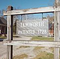
Tamworth is a small, historic village in Cumberland County, Virginia, United States. It was first officially recognized in 1728. The village is located along Tamworth Road. For a long time, farming was important here. People also used a gristmill and a special dam called a weir on Muddy Creek to grind grain.
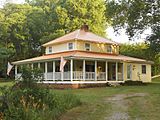
Besides the mill, Tamworth has several old buildings. These include the miller's house, a farmhouse, barns, other small buildings, a post office, and Tamworth Cottage. These buildings are privately owned. You can only see them by making an appointment.
History of Tamworth
The gristmill in Tamworth is also known as Muddy Creek Mills or Moon's Mill. Nicholas Davies built the mill in 1753. Richard James made it bigger in 1775. The mill stopped working in the mid-1950s. Because of its history, the mill was added to the National Register of Historic Places in 1974. This means it is a very important historical site.
The old post office building was built in 1792. It also served as a general store where people could buy things. The US Postal Service closed it in the late 1980s, and it has not been used since. The post office building has a special roof. It is covered with slate tiles that have a fancy pattern.
Tamworth Cottage was built between the 1750s and late 1700s. It was moved to its current spot later on. The cottage was made much larger and fixed up in 1981.
In 2019, parts of the movie Harriet were filmed in Tamworth. The old mill was a main part of the movie set. Some new buildings, like slave quarters and a corn crib, were built for the film.
Tamworth's Geography
Tamworth is in the Piedmont area of Virginia. This is in the northeast part of Cumberland County. Muddy Creek flows through Tamworth. This creek then flows into the James River.
Tamworth is about 57.9 meters (190 feet) above sea level. It is also about 1.6 kilometers (1 mile) from where Muddy Creek meets the James River. At Tamworth, Muddy Creek forms the border between Cumberland and Powhatan counties.
A concrete bridge carries traffic over Muddy Creek. This bridge was built in 1939. It has two lanes for cars. The bridge was repaired a lot in 2011.
Tamworth is in the Eastern Time Zone. Like the rest of Virginia, it uses daylight saving time. This means clocks are moved forward in spring and back in fall.
Tamworth's Weather
The weather in Tamworth changes with the seasons. In July, the average high temperature is about 30.9 degrees Celsius (87.6 degrees Fahrenheit). In January, the average low temperature is about -3.9 degrees Celsius (25 degrees Fahrenheit).
Tamworth gets about 116.8 centimeters (46 inches) of rain each year. It usually gets about 19.3 centimeters (7.6 inches) of snow per year. There are almost twice as many sunny days as rainy days. The UV index, which measures sun strength, is usually around 4.6. Tamworth is in USDA Plant Hardiness Zone 7a. This zone helps gardeners know which plants will grow well there.
Gallery
-
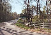
Tamworth highway sign
-
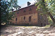
Muddy Creek Mill
-
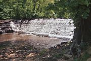
Muddy Creek Weir


-
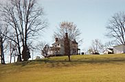
Farm House
-
Tamworth Cottage
-
Tamworth 1723


