Cumberland, Virginia facts for kids
Quick facts for kids
Cumberland, Virginia
|
|
|---|---|

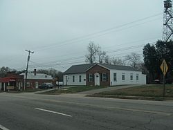
Central Cumberland in 2015
|
|
| Country | United States |
| State | Virginia |
| County | Cumberland |
| Area | |
| • Total | 4.19 sq mi (10.84 km2) |
| • Land | 4.17 sq mi (10.79 km2) |
| • Water | 0.02 sq mi (0.06 km2) |
| Elevation | 455 ft (139 m) |
| Population
(2020)
|
|
| • Total | 365 |
| • Density | 94/sq mi (36.4/km2) |
| Time zone | UTC−5 (Eastern (EST)) |
| • Summer (DST) | UTC−4 (EDT) |
| ZIP code |
23040
|
| Area code(s) | 804 |
| FIPS code | 51-20768 |
| GNIS feature ID | 1498472 |
Cumberland is a small community in Virginia, United States. It is known as a census-designated place (CDP). This means it's an area that the government counts for population, but it's not officially a city or town with its own local government.
Cumberland is also the county seat of Cumberland County. A county seat is like the main town or capital of a county. It's where the county government offices are located.
Contents
Where is Cumberland, Virginia?
Cumberland is located in the state of Virginia. It sits along two important roads: U.S. Route 60 and State Route 45. These roads help connect Cumberland to other places.
Distance to Nearby Cities
Cumberland is about 48 miles (77 kilometers) west of Richmond. Richmond is the capital city of Virginia. It is also about 51 miles (82 kilometers) east of Amherst.
How Many People Live in Cumberland?
The population of Cumberland is quite small. According to the 2020 census, there were 365 people living there. This makes it a quiet and close-knit community.
See also
 In Spanish: Cumberland (Virginia) para niños
 | Delilah Pierce |
 | Gordon Parks |
 | Augusta Savage |
 | Charles Ethan Porter |


