Goochland County, Virginia facts for kids
Quick facts for kids
Goochland County
|
||
|---|---|---|

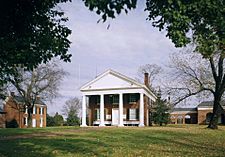
Goochland County Court Square
|
||
|
||

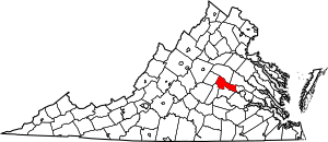
Location within the U.S. state of Virginia
|
||
 Virginia's location within the U.S. |
||
| Country | ||
| State | ||
| Founded | 1728 | |
| Named for | Sir William Gooch | |
| Seat | Goochland | |
| Area | ||
| • Total | 290 sq mi (800 km2) | |
| • Land | 281 sq mi (730 km2) | |
| • Water | 8 sq mi (20 km2) 2.9% | |
| Population
(2020)
|
||
| • Total | 24,727 | |
| • Density | 85.3/sq mi (32.9/km2) | |
| Time zone | UTC−5 (Eastern) | |
| • Summer (DST) | UTC−4 (EDT) | |
| Congressional district | 5th | |
Goochland County is a county located in the Piedmont region of Virginia. The James River forms its southern border. In 2020, about 24,727 people lived there. Its main town, or county seat, is called Goochland. Goochland County is part of the larger Greater Richmond Region.
Contents
History of Goochland County
Early Native American Life
Long before Europeans arrived in the 1600s, the land of Virginia was home to many Native American tribes. These tribes had lived there for thousands of years. In the Piedmont area, where Goochland County is now, lived the Monacan tribe. They spoke a language called Siouan. Records show they had villages west of a place the colonists later called Manakin Town on the James River.
The Monacan and other Siouan-speaking tribes often had conflicts with the Powhatan Confederacy. The Powhatan tribes spoke Algonquian languages and lived closer to the coast. Tribes from the north, like the Iroquois, also sometimes raided the area.
By the late 1600s, many Monacan people had died from wars and diseases brought by the English colonists. The remaining Monacan joined other Siouan tribes.
A very old Native American path, called the Three Chopt Trail, runs through a large part of Goochland County. This trail was marked by three hatchet chops on trees to guide travelers. Today, U.S. Route 250 generally follows this old path from Richmond to Charlottesville.
How Goochland County Was Formed
In 1634, the colonial government divided Virginia into eight shires, like counties in England. Henrico was one of these shires.
Some of the first European settlers in this area were French Huguenots. These were religious refugees who received land in 1700 and 1701. They settled about 20 miles up the James River from its falls. They created villages known as Manakin-Sabot. Later, they moved to farms and plantations.
Goochland was created in 1728. It was the first county formed from Henrico shire. Goochland County was much larger back then. It included all the land from Tuckahoe Creek west to the Blue Ridge Mountains. This huge area contained all of today's Goochland, Powhatan, Cumberland, Fluvanna, Buckingham, Nelson, and Amherst counties. It also included parts of Appomattox, Campbell, Bedford, and most of Albemarle County. Over time, new counties were formed from Goochland. By 1749, it was reduced to its current size.
The county was named after Sir William Gooch, 1st Baronet. He was the royal lieutenant governor of Virginia from 1727 to 1749. Governor Gooch encouraged people to settle in the western parts of Virginia. This helped protect the colony from Native American tribes and French settlements.
Early colonists in the Piedmont grew tobacco, just like those in the coastal areas. After the American Revolution, tobacco became less profitable. Many farmers in Goochland started growing wheat and other crops. This meant they needed less labor. In the early 1800s, some plantation owners sold enslaved people to the Deep South. There, cotton farms were growing, and the demand for enslaved labor was high.
Goochland Courthouse History
The first court in Goochland County was held in May 1728. The exact spot of this first court is not known. However, it is believed the first courthouse was built between 1730 and 1737. A new courthouse was built in 1763 in Beaverdam. In the early 1800s, the courthouse moved to its current location along Route 6 in central Goochland. The Goochland County Court Square was added to the National Register of Historic Places in 1970.
Goochland During the Revolutionary War
In 1781, during the American Revolution, the British army led by Lord Cornwallis marched through Goochland County. They occupied and destroyed Elkhill, a small estate owned by Thomas Jefferson. They took livestock for food, burned buildings, and captured 27 enslaved people. Many of these enslaved people later died from disease in the British camp.
A spot along the James River became known as Cornwallis Hill. It is said that Cornwallis stopped here on his way to Yorktown. He reportedly admired the view of the James River Valley and thought it would be a perfect place for a house. He was later defeated and surrendered at Yorktown.
General Lafayette, a French hero of the Revolution, visited the United States in 1824 and 1825. On November 2, 1824, General Lafayette left Richmond to visit Monticello, Thomas Jefferson's home. On his way, he stopped at Powell's Tavern in Goochland. He met with American officers and many county citizens there.
Goochland During the Civil War
Goochland County was involved in a battle late in the American Civil War. When the war began, James Pleasants from Goochland County joined the Goochland Light Dragoons, a cavalry unit.
In the winter of 1864, Union Colonel Ulric Dahlgren planned a raid. He wanted to free about 12,000 Union prisoners from Belle Isle in Richmond, the Confederate capital. He also planned to destroy the city. On March 1, 1864, Dahlgren's forces reached plantations in eastern Goochland, including Sabot Hill, Dover, and Eastwood.
On James Pleasants's first night home, Dahlgren's raiders stole his horses. Pleasants quickly went after them on foot. He managed to capture several Union soldiers and recover horses. In total, he captured 15 Union soldiers and recovered 16 horses.
Eastwood plantation was occupied by Plumer Hobson and his wife, who was the daughter of General Henry A. Wise. General Wise, the last governor of Virginia before the war, had arrived at Eastwood the night before. When Union soldiers came looking for him, his daughter told them he was in Charleston. In truth, he was already riding to Richmond to warn the Confederate troops about the raid. Dahlgren then went to Sabot Hill, the home of James Seddon. Seddon's wife invited Dahlgren in for wine, hoping to delay him. Thanks to the quick thinking of these families, General Wise was able to warn Richmond, and Dahlgren's raid was defeated.
After the Civil War
After the Civil War, Goochland County used a system called "convict leasing" in 1878 to build roads. This system allowed the state to lease out prisoners as laborers. It was often used to force African Americans into conditions similar to slavery. Laws were passed for minor offenses, and if people could not pay the fines, they were jailed and leased out. This system led to much abuse of the laborers.
In 1918, the Daughters of the Confederacy placed a monument to Confederate soldiers on the Goochland Courthouse green. Robert E. Lee's grandson, Robert E. Lee, attended the unveiling.
Churches in Goochland
In 1720, the area had two parishes, St. James and Henrico. When Goochland County was formed, St. James Parish covered both sides of the James River and westward. Later, as new counties were formed, St. James Parish was divided. St. James Northam Parish covered most of Goochland.
Early churches in St. James Northam Parish were Anglican (now Episcopal). These included Dover Episcopal, Beaverdam Episcopal, and Lickinghole Episcopal. Dover was built in 1724.
Byrd Presbyterian Church is a notable church. Its congregation started in 1748. They built their first church in 1759. In 1838, a new church was built, which is still used today. It has many original features, like its slate roof. The cemetery there has been preserved since 1838.
After the Civil War, one of the first independent Black churches was Second Union Baptist Church, founded in 1865. Many formerly enslaved people left white churches to form their own. Today, Goochland County has many churches, including Episcopal, Baptist, Methodist, Presbyterian, and non-denominational Christian churches.
Historic Homes in Goochland
- Tuckahoe Plantation: This is one of the oldest plantation homes in the county. It has a schoolhouse where Thomas Jefferson and his cousins were educated.
- Sabot Hill: Built in 1855, this home belonged to James A. Seddon. He was the Secretary of War for the Confederate States of America during the Civil War. The house was damaged during Dahlgren's Raid.
- Woodlawn: This home was built before 1760. In 1834, it was bought by Colonel Thomas Taylor, a hero of the Mexican–American War.
- Clover Forest Plantation: The land for this plantation was first claimed in 1714. The main part of the house was built between 1807 and 1811.
You can find more information about historic homes in Goochland through the Goochland County Historical Society.
School Bus Safety Improvements
In 1973, a company called Wayne Corporation created a safer school bus design called the Lifeguard. They held a contest to get ideas for improving school bus safety. The grand prize was a new Lifeguard school bus. Pearl P. Randolph, the first Black member of the Goochland County School Board, won the contest.
Her winning idea was to put special sound-absorbing materials in the ceilings of school buses. This would help reduce noise and distractions for the driver. Because of her idea, Goochland County Public Schools received a new school bus. Later, smaller versions of these materials were developed for buses, especially when noisier diesel engines became common in the 1980s.
Economy of Goochland County
West Creek Business Park
Goochland's growth in the early 2000s was helped by the building of the West Creek Business Park. Also, the completion of State Route 288 connected the county to major highways like I-64 and I-95. This business park attracted many companies. These include the main offices for Farm Bureau of Virginia and Performance Food Group (PFG), as well as Hallmark Youth Care and CarMax.
Top Employers
Here are some of the largest employers in Goochland County:
| # | Employer | # of employees | Community |
|---|---|---|---|
| 1 | Capital One | 5,600 | West Creek Business Park |
| 2 | CarMax | 987 | West Creek Business Park |
| 3 | Luck Stone | 331 | Manakin-Sabot |
| 4 | Virginia Farm Bureau | 300 | West Creek Business Park |
| 5 | Federal Reserve Bank of Richmond | 200 | West Creek Business Park |
| 6 | Performance Food Group | 180 | West Creek Business Park |
| 7 | Hermitage Country Club | 150 | Manakin-Sabot |
| 8 | Food Lion | 110 | Manakin-Sabot and Goochland |
| 9 | Elk Hill | 100 | Goochland |
Geography of Goochland County
Goochland County covers about 290 square miles. Most of this is land, with about 8 square miles being water. The county is drained by the James River.
Neighboring Counties
- Louisa County – to the north
- Hanover County – to the northeast
- Henrico County – to the east
- Powhatan County – to the south
- Cumberland County – to the southwest
- Fluvanna County – to the west
Main Roads
 I-64 - Runs along the northern border with Louisa County.
 US 250 - Runs next to I-64, also near the Louisa County line.
 US 522 - Goes through the county, crossing SR 6, US-250, and I-64 in Louisa County.
 SR 6 - Runs along the James River in the southern part of the county.
 SR 288 - Runs along the eastern county line from I-64 to Powhatan County.
People of Goochland County
Population Changes Over Time
The population of Goochland County has grown over the years. In 1790, about 9,053 people lived there. By 1970, the population reached over 10,000. In 2020, the population was 24,727.
Who Lives in Goochland County?
In 2020, most people living in Goochland County were White (about 77%). About 13% were Black or African American. Other groups included Asian (about 2%), Native American, Pacific Islander, and people of two or more races. About 3.5% of the population was Hispanic or Latino, who can be of any race.
Notable People from Goochland County
- Thomas Jefferson – He lived at Shadwell, which was once part of the county.
- Thomas Mann Randolph Jr. – The 21st Governor of Virginia.
- James Pleasants – The 22nd Governor of Virginia.
- Edward Bates – Served as the 26th United States Attorney General under President Abraham Lincoln.
- James Seddon – Served as the Confederate Secretary of War.
- John Berry Meachum – A businessman, educator, and founder of the oldest Black church in Missouri.
- Josephine Turpin Washington – An educator and writer (1861–1949).
- Justin Verlander – A famous baseball pitcher for the Houston Astros, who grew up in the county.
- John Hicks – A baseball catcher and first baseman for the Detroit Tigers.
- Giles Beecher Jackson – An African-American lawyer, newspaper publisher, and civil rights activist (1853–1924).
Communities in Goochland County
Goochland County does not have any incorporated towns or cities. Instead, it has several unincorporated communities:
Main Community
- Goochland (this is also the county seat)
Other Communities
- Centerville
- Crozier
- Fife
- Hadensville
- Maidens
- Manakin-Sabot
- Oilville
- Pickels
- Sandy Hook
- Shannon Hill
Images for kids
See also
 In Spanish: Condado de Goochland para niños
 | Charles R. Drew |
 | Benjamin Banneker |
 | Jane C. Wright |
 | Roger Arliner Young |


