Appomattox County, Virginia facts for kids
Quick facts for kids
Appomattox County
|
||
|---|---|---|

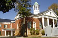
The Appomattox County Courthouse in October 2007
|
||
|
||

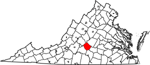
Location within the U.S. state of Virginia
|
||
 Virginia's location within the U.S. |
||
| Country | ||
| State | ||
| Founded | 1845 | |
| Named for | Appomattox River | |
| Seat | Appomattox | |
| Largest town | Appomattox | |
| Area | ||
| • Total | 335 sq mi (870 km2) | |
| • Land | 333 sq mi (860 km2) | |
| • Water | 1.2 sq mi (3 km2) 0.4% | |
| Population
(2020)
|
||
| • Total | 16,119 | |
| • Density | 48.12/sq mi (18.578/km2) | |
| Time zone | UTC−5 (Eastern) | |
| • Summer (DST) | UTC−4 (EDT) | |
| Congressional district | 5th | |
Appomattox County is a county in the United States. It is located in the Piedmont region of Virginia. This area is near the center of the state.
The county is part of the Lynchburg area. Its main town, or county seat, is called Appomattox. The county was started in 1845. It was named after the Appomattox River. The river itself was named after the Appamatuck Native American people. As of 2020, about 16,119 people live in Appomattox County.
Contents
History of Appomattox County
Appomattox County was formed in 1845. It was made from parts of four other Virginia counties. These were Buckingham, Prince Edward, Campbell, and Charlotte counties. A few years later, in 1848, another piece of Campbell County was added.
The county's name comes from the Appomattox River. The river was named after the Appamatuck Indians. They were a historic Native American tribes in Virginia group. They spoke the Algonquian language.
Appomattox became famous on April 9, 1865. This was a very important day in the American Civil War. Confederate General Robert E. Lee met with Union General Ulysses S. Grant. They met at the village of Appomattox Court House. General Lee officially surrendered to General Grant. This event effectively ended the American Civil War. The surrender happened at the McLean House. This was the home of a man named Wilmer McLean.
Geography and Location
Appomattox County covers a total area of about 335 square miles. Most of this area, about 333 square miles, is land. Only a small part, about 1.2 square miles, is water.
Neighboring Counties
Appomattox County shares its borders with several other counties:
- Nelson County, Virginia - to the north
- Buckingham County, Virginia - to the northeast
- Prince Edward County, Virginia - to the southeast
- Charlotte County, Virginia - to the south
- Campbell County, Virginia - to the southwest
- Amherst County, Virginia - to the northwest
Special Protected Areas
- Appomattox Court House National Historical Park is a national park in the county. It protects the historic site of the Civil War surrender.
Main Roads in Appomattox
Several important highways pass through Appomattox County:
 US 60
US 60 US 460
 SR 24
SR 24 SR 26
SR 26 SR 47
SR 47 SR 131
Population Information
The population of Appomattox County has changed over the years. Here's a look at how many people have lived there during different census counts:
| Historical population | |||
|---|---|---|---|
| Census | Pop. | %± | |
| 1850 | 9,193 | — | |
| 1860 | 8,889 | −3.3% | |
| 1870 | 8,950 | 0.7% | |
| 1880 | 10,080 | 12.6% | |
| 1890 | 9,589 | −4.9% | |
| 1900 | 9,662 | 0.8% | |
| 1910 | 8,904 | −7.8% | |
| 1920 | 9,255 | 3.9% | |
| 1930 | 8,402 | −9.2% | |
| 1940 | 9,020 | 7.4% | |
| 1950 | 8,764 | −2.8% | |
| 1960 | 9,148 | 4.4% | |
| 1970 | 9,784 | 7.0% | |
| 1980 | 11,971 | 22.4% | |
| 1990 | 12,298 | 2.7% | |
| 2000 | 13,705 | 11.4% | |
| 2010 | 14,973 | 9.3% | |
| 2020 | 16,119 | 7.7% | |
| U.S. Decennial Census 1790-1960 1900-1990 1990-2000 2010 2020 |
|||
Towns and Communities
Appomattox County has a few towns and many smaller communities.
Towns
Census-Designated Place
- Concord (mostly in Campbell County)
Other Communities
See also
 In Spanish: Condado de Appomattox para niños
 | Audre Lorde |
 | John Berry Meachum |
 | Ferdinand Lee Barnett |


