
Campbell County, Virginia facts for kids
Quick facts for kids
Campbell County
|
|||||
|---|---|---|---|---|---|

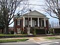
Campbell County Courthouse in Rustburg
|
|||||
|
|||||

Location within the U.S. state of Virginia
|
|||||
 Virginia's location within the U.S. |
|||||
| Country | |||||
| State | |||||
| Founded | 1782 | ||||
| Named for | General William Campbell | ||||
| Seat | Rustburg | ||||
| Largest town | Altavista | ||||
| Area | |||||
| • Total | 507 sq mi (1,310 km2) | ||||
| • Land | 504 sq mi (1,310 km2) | ||||
| • Water | 3.5 sq mi (9 km2) 0.7% | ||||
| Population
(2020)
|
|||||
| • Total | 55,696 |
||||
| • Density | 110/sq mi (40/km2) | ||||
| Time zone | UTC−5 (Eastern) | ||||
| • Summer (DST) | UTC−4 (EDT) | ||||
| Congressional district | 5th | ||||


Campbell County is a place in the south-central part of Virginia. It is a county, which is like a large area with its own local government.
Campbell County is in the Piedmont region of Virginia, which is an area of rolling hills. It is also close to the Blue Ridge Mountains. The main town and government center of the county is Rustburg.
The county was started in 1782. It was named after General William Campbell. He was a hero in the American Revolutionary War. At first, the county's economy was based on growing tobacco.
Campbell County is part of the Lynchburg metropolitan area. In 2020, about 55,696 people lived there. The number of people living in Campbell County has grown a lot since 1930.
The city of Lynchburg was also started in Campbell County in 1786. It became its own separate city in 1852.
Template:TOC limit=3
Contents
The History of Campbell County

Long ago, Native American tribes lived in the Campbell County area. These included the Monacan, Iroquois, and Cherokee tribes. Later, European settlers moved in, and the Native Americans moved west.
In 1727, Sir William Gooch wanted more people to settle here. He offered two special deals. First, if you settled by the Staunton River, you would not have to pay taxes for ten years. Second, you could claim 400 acres of land just by building a cabin and planting some grain.
Early Settlers and Their Journey
Many Scotch-Irish families started settling in the area in the 1700s. Some of their names were Irvin, Mitchell, McCue, and Campbell. Many of these families came on a ship called the George and Ann. The ship's captain tried to trick them, but another captain helped them land safely.
These families then traveled south to find the land Sir William Gooch had offered. It was hard to get new settlers. So, the Governor allowed Scotch-Irish immigrants who were Presbyterian to have religious freedom. This helped bring more people to the new county.
The first European settlers arrived in the late 1730s. They were mainly Scotch-Irish Presbyterians. Campbell County was officially formed in 1782. It was the first county created after the American Revolution. The county was named after General William Campbell. He was famous for his role in the 1780 Battle of Kings Mountain.
Growth of Towns


A man named Jeremiah Rust gave the land for the county's main town, Rustburg. Other towns like Altavista and Brookneal grew because they were good for business. They were also located where important trails met. Altavista was planned in 1907 because it was a good spot for a railroad.
For a long time, tobacco was the main crop and the basis of the economy. There were also early factories. Brookneal was important for tobacco and textiles because it was on the Staunton River. Today, Campbell County has changed. It is now a mix of suburban and rural areas.
Campbell County also had iron factories. They started before the American Revolution and closed in 1875. One of the old factory buildings is still standing today.
Education and Community
The first public school in Campbell County opened in 1871. This was after the Civil War. In 1878, Lynchburg became a separate city from Campbell County.
The first school fair in Virginia was held in Rustburg in 1908. It was a place to show off students' best work and learning.
People from Campbell County have helped in many wars. They have had soldiers in the American Revolution, the Civil War, World War I, World War II, the Korean War, the Vietnam War, the Gulf War, and the War in Afghanistan.
Religious History
Most of the early settlers in Campbell County were Protestant Christians. Many were Quakers and Presbyterians. They came seeking religious freedom. Many moved from places like Colonial Williamsburg where other religions were not as accepted.

The Quakers became important in Campbell County. Sarah Clark Lynch, whose son founded Lynchburg, helped them. Their request for a meeting house was approved. The South River Friends Meeting House was built.
Later, many Quakers left the area. They disagreed with others about slavery and the American Revolution. Quakers believed in peace and did not want to fight in wars. This made some neighbors angry. Quakers also strongly believed that slavery was wrong. In 1817, they freed all their slaves. These beliefs caused tension, and many Quakers moved West.
The Presbyterians were mainly Scotch-Irish people. They came to America for religious freedom and a better life. They first settled in Pennsylvania. Then, they moved to Virginia because of Governor Gooch's offers. They stayed in Campbell County and helped it grow.
Geography of Campbell County
Campbell County covers about 507 square miles (1,313 square kilometers). Most of this is land, with a small amount of water.
Neighboring Areas
Campbell County shares borders with these places:
- Lynchburg, Virginia – to the northwest (this is an independent city)
- Amherst County, Virginia – to the north
- Appomattox County, Virginia – to the northeast
- Charlotte County, Virginia – to the east
- Halifax County, Virginia – to the southeast
- Pittsylvania County, Virginia – to the southwest
- Bedford County, Virginia – to the west
Main Roads
Several important roads run through Campbell County:
 US 29
US 29 US 460
 US 501
 SR 24
SR 24 SR 40
SR 40 SR 43
SR 43
Population Information
The number of people living in Campbell County has changed over time. Here's a look at the population counts from different years:
| Historical population | |||
|---|---|---|---|
| Census | Pop. | %± | |
| 1790 | 7,685 | — | |
| 1800 | 9,866 | 28.4% | |
| 1810 | 11,001 | 11.5% | |
| 1820 | 16,569 | 50.6% | |
| 1830 | 20,350 | 22.8% | |
| 1840 | 21,030 | 3.3% | |
| 1850 | 23,245 | 10.5% | |
| 1860 | 26,197 | 12.7% | |
| 1870 | 28,384 | 8.3% | |
| 1880 | 36,250 | 27.7% | |
| 1890 | 41,087 | 13.3% | |
| 1900 | 23,256 | −43.4% | |
| 1910 | 23,043 | −0.9% | |
| 1920 | 26,716 | 15.9% | |
| 1930 | 22,885 | −14.3% | |
| 1940 | 26,048 | 13.8% | |
| 1950 | 28,877 | 10.9% | |
| 1960 | 32,958 | 14.1% | |
| 1970 | 43,319 | 31.4% | |
| 1980 | 45,424 | 4.9% | |
| 1990 | 47,572 | 4.7% | |
| 2000 | 51,078 | 7.4% | |
| 2010 | 54,842 | 7.4% | |
| 2020 | 55,696 | 1.6% | |
| U.S. Decennial Census 1790–1960 1900–1990 1990–2000 2010 2020 |
|||
Population in 2020
In 2020, the U.S. Census counted 55,696 people in Campbell County. Most people were White, but there were also many Black or African American residents. The county is becoming more diverse, with more people of mixed races and Hispanic or Latino backgrounds.
Towns and Communities
Campbell County has several towns and communities:
Towns
Census-Designated Places
These are areas that are like towns but are not officially incorporated:
Other Communities
These are smaller, unincorporated communities:
- Castle Craig
- Evington
- Gladys
- Kingston
- Long Island
- Lynch Station
- New London
Some of these areas use Lynchburg addresses for mail.
Sports and Fun Activities
Campbell County offers many sports and recreation options:
- High School Sports: You can find sports teams at Altavista High School, Brookville High School, Rustburg High School, and William Campbell High School.
- Youth Sports:
- Brookville Bees Youth Athletic Association: This group offers football and basketball for young people.
- Brookville Soccer Club: This group provides soccer for kids.
- Timberlake Dixie Youth: This organization offers youth baseball.
- Parks and Recreation:
- Campbell County Parks & Recreation: This department manages many local parks and activities.
- Timbrook Park: A great place for hiking.
- Other Activities:
- Altavista YMCA: Offers various fitness and community programs.
- Timber Lake: A spot where you can go fishing, paddle boating, and swimming.
Images for kids
-
Campbell County Courthouse in Rustburg
See also
 In Spanish: Condado de Campbell (Virginia) para niños
