Rustburg, Virginia facts for kids
Quick facts for kids
Rustburg, Virginia
|
|
|---|---|

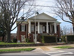
Former county courthouse, now a museum
|
|

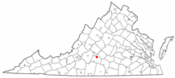
Location of Rustburg, Virginia
|
|
| Country | United States |
| State | Virginia |
| County | Campbell |
| Area | |
| • Total | 12.6 sq mi (32.7 km2) |
| • Land | 12.5 sq mi (32.4 km2) |
| • Water | 0.1 sq mi (0.3 km2) |
| Elevation | 886 ft (270 m) |
| Population
(2010)
|
|
| • Total | 1,431 |
| • Density | 114/sq mi (44.2/km2) |
| Time zone | UTC−5 (Eastern (EST)) |
| • Summer (DST) | UTC−4 (EDT) |
| ZIP code |
24588
|
| Area code(s) | 434 |
| FIPS code | 51-69536 |
| GNIS feature ID | 1500006 |
Rustburg is a small community in Campbell County, Virginia, United States. It is known as a census-designated place (CDP), which means it's a special area defined for collecting population data. Rustburg is also the county seat of Campbell County. This means it's where the main government offices for the county are located.
In 2020, about 1,585 people lived in Rustburg. It is part of the larger Lynchburg area.
Rustburg has several public schools. Students attend Rustburg High School. Younger students go to Rustburg Middle School, Rustburg Elementary School, and Yellow Branch Elementary School. There are also special centers like the Fray Educational Center and the Campbell County Technical Center.
History of Rustburg
Rustburg got its name from a person named Jeremiah Rust. In 1784, he gave 50 acres (about 200,000 square meters) of his land to create the village. This is how the community began.
A very important building in Rustburg is the Campbell County Courthouse. This historic building was added to the National Register of Historic Places in 1981. This list helps protect important places in the United States.
Where is Rustburg?
Rustburg is located in the northern part of Campbell County. You can find it at coordinates 37.273731 degrees North and 79.098914 degrees West.
U.S. Route 501 goes right through the middle of Rustburg. If you travel north on this road, you'll reach Lynchburg in about 11 miles (18 km). If you go south, you'll get to Brookneal in about 20 miles (32 km).
Another important road is Virginia Route 24. It also passes through the center of town. Traveling northeast on Route 24 will take you to Concord in about 9 miles (14 km). Going west for about 5 miles (8 km) will lead you to U.S. Route 29 near Yellow Branch.
Northeast of Rustburg, there's a tall hill called Long Mountain. It reaches a height of about 1,440 feet (439 meters) and has communication towers on top.
The total area of Rustburg is about 32.7 square kilometers (12.6 square miles). Most of this area, about 32.4 square kilometers (12.5 square miles), is land. The remaining 0.3 square kilometers (0.1 square miles) is water.
People of Rustburg
The census helps us learn about the people living in Rustburg. In 2000, there were 1,271 people living here. These people lived in 474 households, and 321 of these were families.
The population density was about 117.3 people per square mile (45.3 people per square kilometer). Most people in Rustburg were White (about 74.82%), and about 23.60% were African American. A small number of people were Native American, Asian, or from other backgrounds. About 0.16% of the population was Hispanic or Latino.
About 29.7% of households had children under 18 living with them. Many households (51.9%) were married couples living together. About 11.6% of households had a female head with no husband present.
The average household had about 2.41 people, and the average family had about 3.00 people.
The population was spread out by age. About 21.8% of the people were under 18 years old. About 13.9% were 65 years or older. The average age of people in Rustburg was 37 years.
The median income for a household in Rustburg was about $31,797. This means half of the households earned more than this amount, and half earned less. For families, the median income was about $31,758.
See also
 In Spanish: Rustburg (Virginia) para niños
 | Bayard Rustin |
 | Jeannette Carter |
 | Jeremiah A. Brown |

