Halifax County, Virginia facts for kids
Quick facts for kids
Halifax County
|
||
|---|---|---|
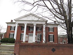
Halifax County Courthouse
|
||
|
||
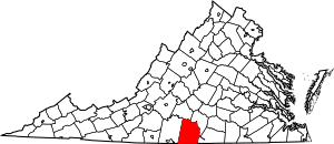
Location within the U.S. state of Virginia
|
||
 Virginia's location within the U.S. |
||
| Country | ||
| State | ||
| Founded | 1752 | |
| Named for | George Montagu-Dunk, 2nd Earl of Halifax | |
| Seat | Halifax | |
| Largest town | South Boston | |
| Area | ||
| • Total | 830 sq mi (2,100 km2) | |
| • Land | 818 sq mi (2,120 km2) | |
| • Water | 12 sq mi (30 km2) 1.4% | |
| Population
(2020)
|
||
| • Total | 34,022 | |
| • Density | 40.99/sq mi (15.83/km2) | |
| Time zone | UTC−5 (Eastern) | |
| • Summer (DST) | UTC−4 (EDT) | |
| Congressional district | 5th | |
Halifax County is a county found in the state of Virginia. In 2020, about 34,022 people lived there. The main town, or county seat, is Halifax.
Contents
History
For thousands of years, different groups of Native Americans lived in this area. When English settlers arrived, they met Native Americans who spoke a language called Siouan.
Halifax County was created in 1752 by English colonists. They came from a nearby area called Lunenburg County. The county was named after George Montague-Dunk, 2nd Earl of Halifax. He was an important English leader at the time.
For many years, the town of South Boston in Halifax County was a separate area. But on July 1, 1995, South Boston became a town again and rejoined Halifax County.
Geography
Halifax County covers a total area of about 830 square miles. Most of this area, about 818 square miles, is land. The rest, about 12 square miles, is water.
Neighboring Areas
Halifax County shares its borders with several other counties:
- Campbell County (to the northwest)
- Charlotte County (to the northeast)
- Mecklenburg County (to the east)
- Granville County (to the southeast)
- Person County (to the south)
- Caswell County (to the southwest)
- Pittsylvania County (to the west)
Main Roads
Several important roads pass through Halifax County:
 US 15
US 15 US 58
US 58 US 360
 US 501
 SR 34
SR 34 SR 40
SR 40 SR 49
SR 49 SR 92
SR 92 SR 96
SR 96 SR 129
 SR 304
People of Halifax County
The population of Halifax County has changed over many years. Here's how the number of people living there has grown and changed:
| Historical population | |||
|---|---|---|---|
| Census | Pop. | %± | |
| 1790 | 14,722 | — | |
| 1800 | 19,377 | 31.6% | |
| 1810 | 22,133 | 14.2% | |
| 1820 | 19,060 | −13.9% | |
| 1830 | 28,034 | 47.1% | |
| 1840 | 25,936 | −7.5% | |
| 1850 | 25,962 | 0.1% | |
| 1860 | 26,520 | 2.1% | |
| 1870 | 27,828 | 4.9% | |
| 1880 | 33,588 | 20.7% | |
| 1890 | 34,424 | 2.5% | |
| 1900 | 37,197 | 8.1% | |
| 1910 | 40,044 | 7.7% | |
| 1920 | 41,374 | 3.3% | |
| 1930 | 41,283 | −0.2% | |
| 1940 | 41,271 | 0.0% | |
| 1950 | 41,442 | 0.4% | |
| 1960 | 33,637 | −18.8% | |
| 1970 | 30,076 | −10.6% | |
| 1980 | 30,599 | 1.7% | |
| 1990 | 29,033 | −5.1% | |
| 2000 | 37,355 | 28.7% | |
| 2010 | 36,241 | −3.0% | |
| 2020 | 34,022 | −6.1% | |
| U.S. Decennial Census 1790-1960 1900-1990 1990-2000 2010 2020 |
|||
In 2020, the total population was 34,022 people. Most people in Halifax County are White (about 59.5%). The next largest group is Black or African American (about 34.5%). There are also smaller groups of Asian, Native American, and people of mixed races. About 2.2% of the population is Hispanic or Latino.
Towns and Communities
Halifax County has several towns and other communities where people live.
Towns
Census-designated places
These are areas that are like towns but are not officially incorporated.
- Clover
- Cluster Springs
- Mountain Road
- Nathalie
- Riverdale
Other unincorporated communities
These are smaller communities that are not officially towns or census-designated places.
- Alton
- Cody
- Turbeville
- Vernon Hill
See also
 In Spanish: Condado de Halifax (Virginia) para niños
 | Kyle Baker |
 | Joseph Yoakum |
 | Laura Wheeler Waring |
 | Henry Ossawa Tanner |


