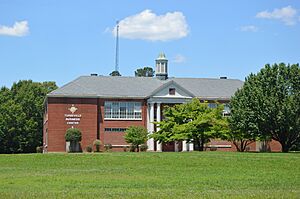
Turbeville, Virginia facts for kids
Turbeville is a small place located in Halifax County, Virginia, in the United States. It is known as an unincorporated community, which means it doesn't have its own local government like a city or town. Instead, it's managed by the larger county government. Turbeville sits at an elevation of 535 feet (about 163 meters) above sea level.
Contents
What is an Unincorporated Community?
An unincorporated community is a group of homes and businesses that are not part of an official city or town. They are usually governed by the county they are in. This means that services like police, fire, and schools are provided by the county government. People living in unincorporated areas still have addresses and often feel like they are part of a distinct place, even without their own mayor or town council.
Why are Some Places Unincorporated?
Many communities start small and grow over time. If a community doesn't grow large enough, or if its residents prefer to remain under county rule, it might stay unincorporated. This can sometimes mean lower taxes or fewer local rules compared to a city. It also means that decisions for the area are made at the county level, which covers a much larger region.
Where is Turbeville Located?
Turbeville is found in the southern part of Virginia, within a large area called Halifax County. Virginia is one of the original thirteen colonies of the United States and is known for its rich history. Halifax County is one of the biggest counties in Virginia by land area. It is located in the south-central part of the state, near the border with North Carolina.
Exploring Halifax County
Halifax County is a mostly rural area with a lot of natural beauty. It has many farms and forests. The county seat, which is like its main town, is Halifax. Other communities in the county include South Boston and Clover. The county offers outdoor activities like fishing and boating on the Staunton River.
How High is Turbeville?
Turbeville's elevation is 535 feet (163 meters) above sea level. This measurement tells us how high the land is compared to the ocean's surface. Knowing a place's elevation can be important for understanding its climate, geography, and even how water flows in the area. For example, places at higher elevations often have cooler temperatures.
 | Shirley Ann Jackson |
 | Garett Morgan |
 | J. Ernest Wilkins Jr. |
 | Elijah McCoy |


