Mecklenburg County, Virginia facts for kids
Quick facts for kids
Mecklenburg County
|
||
|---|---|---|

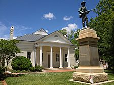
Mecklenburg County Courthouse
|
||
|
||

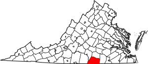
Location within the U.S. state of Virginia
|
||
 Virginia's location within the U.S. |
||
| Country | ||
| State | ||
| Founded | 1765 | |
| Named for | Charlotte of Mecklenburg-Strelitz | |
| Seat | Boydton | |
| Largest town | South Hill | |
| Area | ||
| • Total | 679 sq mi (1,760 km2) | |
| • Land | 625 sq mi (1,620 km2) | |
| • Water | 54 sq mi (140 km2) 7.9% | |
| Population
(2020)
|
||
| • Total | 30,319 | |
| • Density | 44.65/sq mi (17.240/km2) | |
| Time zone | UTC−5 (Eastern) | |
| • Summer (DST) | UTC−4 (EDT) | |
| Congressional district | 5th | |

Mecklenburg County is a special area called a county in the state of Virginia. In 2020, about 30,319 people lived here. The main town where the county government is located is Boydton.
Contents
History
Mecklenburg County was officially started on March 1, 1765. Before that, it was part of Lunenburg County. In 1764, the government of Virginia decided to split Lunenburg County into three new counties. This was because more and more people were moving into the area. The new counties were Lunenburg, Charlotte, and Mecklenburg.
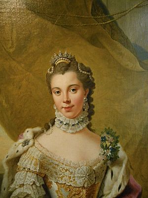
The county was named after Charlotte of Mecklenburg-Strelitz. She was a queen from Germany who married the King of Great Britain.
The first county government had 13 members. They helped run the county. Benjamin Baird was the first mayor.
Education
The schools in Mecklenburg County are managed by the Mecklenburg County Public Schools. This is the county's education department. The Board of Education helps make decisions about the schools. Paul Nichols is the person in charge, called the County Schools Superintendent.
Geography
Mecklenburg County covers about 679 square miles. Most of this area, about 625 square miles, is land. The rest, about 54 square miles, is water. This means about 7.9% of the county is covered by water.
Neighboring Counties
Mecklenburg County shares its borders with several other counties:
- Lunenburg County to the north
- Brunswick County to the east
- Warren County, North Carolina to the southeast
- Vance County, North Carolina to the south
- Granville County, North Carolina to the southwest
- Halifax County to the west
- Charlotte County to the northwest
Main Roads
Several important roads pass through Mecklenburg County:
 I-85
I-85 US 1
US 1 US 15
US 15 US 58
US 58 SR 4 (U.S. Bicycle Route 1)
 SR 47
SR 47 SR 49
SR 49 SR 92
SR 92 SR 138
People and Population
| Historical population | |||
|---|---|---|---|
| Census | Pop. | %± | |
| 1790 | 14,733 | — | |
| 1800 | 17,008 | 15.4% | |
| 1810 | 18,453 | 8.5% | |
| 1820 | 19,786 | 7.2% | |
| 1830 | 20,477 | 3.5% | |
| 1840 | 20,724 | 1.2% | |
| 1850 | 20,630 | −0.5% | |
| 1860 | 20,096 | −2.6% | |
| 1870 | 21,318 | 6.1% | |
| 1880 | 24,610 | 15.4% | |
| 1890 | 25,359 | 3.0% | |
| 1900 | 26,551 | 4.7% | |
| 1910 | 28,956 | 9.1% | |
| 1920 | 31,208 | 7.8% | |
| 1930 | 32,622 | 4.5% | |
| 1940 | 31,933 | −2.1% | |
| 1950 | 33,497 | 4.9% | |
| 1960 | 31,428 | −6.2% | |
| 1970 | 29,426 | −6.4% | |
| 1980 | 29,444 | 0.1% | |
| 1990 | 29,241 | −0.7% | |
| 2000 | 32,280 | 10.4% | |
| 2010 | 32,727 | 1.4% | |
| 2020 | 30,319 | −7.4% | |
| U.S. Decennial Census 1790-1960 1900-1990 1990-2000 2010 2020 |
|||
In 2020, the total population of Mecklenburg County was 30,319 people. Most people identified as White (about 58.92%). The next largest group was Black or African American (about 34.18%). Other groups included Native American, Asian, and people of mixed races. About 2.71% of the population was Hispanic or Latino.
In 2010, there were 32,727 people living in the county. About 26.5% of homes had children under 18 living there. The average age of people in the county was 41 years old.
Communities
Mecklenburg County has several towns and smaller communities.
Towns
- Boydton (This is the county seat, where the main government offices are)
- Brodnax (part of this town is in another county)
- Chase City
- Clarksville
- La Crosse
- South Hill
Census-designated places
These are areas that are like towns but are not officially incorporated as towns.
Other Unincorporated Communities
These are smaller communities that are not part of any town or census-designated place.
- Buffalo Junction
- Nelson
- Palmer Springs
- Shiny Rock
- Skipwith
See also
 In Spanish: Condado de Mecklenburg (Virginia) para niños
 | William Lucy |
 | Charles Hayes |
 | Cleveland Robinson |


