La Crosse, Virginia facts for kids
Quick facts for kids
La Crosse, Virginia
|
|
|---|---|
 |
|

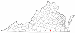
Location of La Crosse, Virginia
|
|
| Country | United States |
| State | Virginia |
| County | Mecklenburg |
| Area | |
| • Total | 1.22 sq mi (3.17 km2) |
| • Land | 1.22 sq mi (3.17 km2) |
| • Water | 0.00 sq mi (0.00 km2) |
| Elevation | 476 ft (145 m) |
| Population
(2020)
|
|
| • Total | 614 |
| • Density | 503.3/sq mi (193.7/km2) |
| Time zone | UTC-5 (Eastern (EST)) |
| • Summer (DST) | UTC-4 (EDT) |
| ZIP code |
23950
|
| Area code(s) | 434 |
| FIPS code | 51-43176 |
| GNIS feature ID | 1495802 |
| Website | Official Website: http://www.townoflacrosse.org |
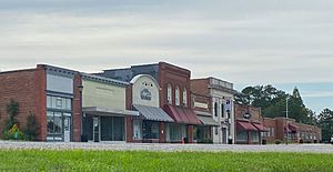
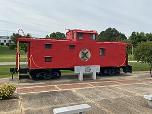
La Crosse is a small town located in Mecklenburg County, Virginia, in the United States. Its name comes from a time when railroad tracks crossed here. You can even see an old caboose right in the middle of town! It's right next to the town of South Hill.
In 2020, about 614 people lived there.
Contents
A Look at La Crosse History
Before 1890, La Crosse was known by a different name: Piney Pond. The town has some important old buildings. The La Crosse Hotel and the O.H.P. Tanner House are so special that they are listed on the National Register of Historic Places. This means they are protected because of their history.
La Crosse was once a busy stop on the Atlantic and Danville Railway. This was a railroad line that helped people and goods travel. In 1902, a company called the People's Warehouse Company was started here. Its main job was to sell tobacco.
Today, you can still see parts of the old railroad. The Tobacco Heritage Trail now runs through the town. This trail follows the path of the old Atlantic and Danville Railway, offering a way to explore the area's history.
Where is La Crosse Located?
La Crosse is found at specific coordinates: 36°41′50″N 78°5′32″W / 36.69722°N 78.09222°W. This helps pinpoint its exact spot on a map.
The United States Census Bureau says that the town covers about 1.2 square miles (which is about 3.0 square kilometers). All of this area is land, meaning there are no large lakes or rivers within the town limits.
Population Changes Over Time
| Historical population | |||
|---|---|---|---|
| Census | Pop. | %± | |
| 1910 | 281 | — | |
| 1920 | 320 | 13.9% | |
| 1930 | 427 | 33.4% | |
| 1940 | 524 | 22.7% | |
| 1950 | 675 | 28.8% | |
| 1960 | 726 | 7.6% | |
| 1970 | 674 | −7.2% | |
| 1980 | 734 | 8.9% | |
| 1990 | 549 | −25.2% | |
| 2000 | 618 | 12.6% | |
| 2010 | 604 | −2.3% | |
| 2020 | 614 | 1.7% | |
| U.S. Decennial Census | |||
The number of people living in La Crosse has changed over the years. In the year 2000, there were 618 people living in the town. These people lived in 263 households, and 160 of those were families.
The town had about 532 people per square mile. There were also 314 housing units available.
About 27% of the households had children under 18 living with them. Many households were single people, especially those aged 65 or older. The average household had about 2.29 people.
The median age of people in La Crosse was 40 years old. This means half the people were younger than 40 and half were older.
See also
 In Spanish: La Crosse (Virginia) para niños
 | Valerie Thomas |
 | Frederick McKinley Jones |
 | George Edward Alcorn Jr. |
 | Thomas Mensah |


